Swell windows becoming quiet. Surf while you can

Sydney, Hunter and Illawarra Surf Forecast by Guy Dixon (issued Friday 29th January)
Best Days: Saturday morning and Sunday morning.
Recap:
The period pulse we were expecting on Thursday came in right on forecast with reports of mundane 2-3ft options kicking noticeably to the 3-5ft mark. North/northwesterly breezes swung northerly throughout the morning allowing options to remain clean/workable, before tending seabreezey later.
Today, the size has eased back to the 3-4ft range under light northerly breezes, tending northeasterly.
This weekend (Saturday 30th - Sunday 31st):
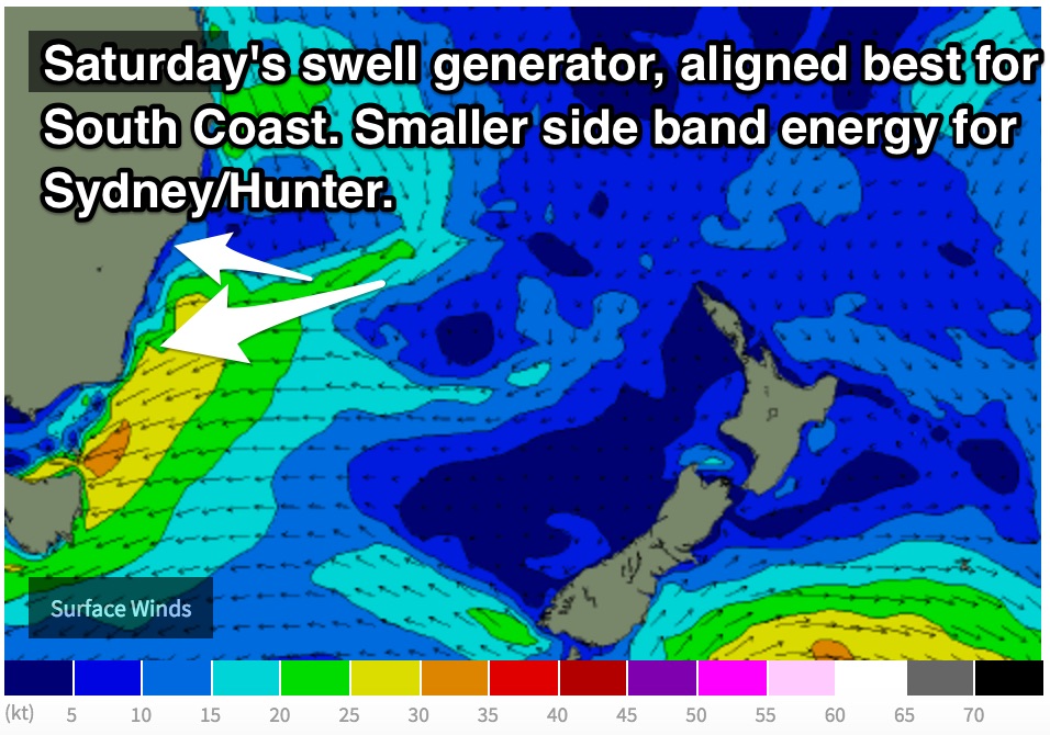 A deep low pressure trough has been residing over eastern Australia during the past few days, gradually edging closer to the coast. As this system has moved east and interacted with a Tasman ridge, a northeasterly fetch has been lingering just offshore.
In addition to the tail end of an underlying easterly groundswell of Ex-Tropical Cyclone Victor, this fetch alone has been providing shorter range energy in the 2ft range across open beaches today.
Models suggest a small low pressure system to develop off the coast of NSW today, creating a very slight intensification, with an easterly fetch increasing along it's southern quadrants.
This fetch is more favourably aligned to the South Coast and should provide options in the 2-3ft range acorss the open beaches of this coastline by Saturday morning, however the coasts further north should still see some energy fill in around the 2ft range on from the east/southeast.
The early session is looking at a light northwesterly breeze, possibly westerly along the Illawarra coast tending light variable by mid-morning. A northeasterly seabreze is then due to come in, so make the most of the early.
Following this intensification, a poorly aligned and weaker fetch is due to linger throughout Saturday over the Tasman sea south of the Sydney coast, however small amounts of east/southeasterly energy should continue to filter in off this system throughout Sunday, albeit small and weak.
Most beaches should fade from the 1-2ft+ range throughout the day, although nice and clean under a northwesterly breeze which has the potential to persist until late morning (some models suggest later).
Next week (Monday 1st onward):
The outlook remains fairly benign for the start of next week, with most swell windows remaining pretty quiet.
Hints of background energy should keep the surf from falling completely flat, although most beaches should only see slight ebbs and pulses not much more than 1ft or so.
This can largely be put down to a long wave ridge becoming established over the Tasman region, excluding frontal activity from our swell windows. At a time like this, we would expect frontal swell generators to be more active to the east and west.
Much of Monday looks to remain clean with light/variable-offshore breezes holding for a good part of the morning, preceding a workable light seabreeze, similarly on Tuesday and Wednesday.
The next best chance of significant surf looks to come on Thursday following a gusty southerly change. The change itself is looking to move up the coast overnight on Wednesday into Thursday morning, causing a strong increase in short range, low quality southerly windswell.
South facing beaches should build to a stormy 5-6ft+ by the afternoon, although without much quality to speak of.
Protected southern corners of the open beaches are will provide a much cleaner wave, but much smaller as the swell fails to refract inwards due to the short periods.
It’s not a great outlook, but we’ve had a good run of swell, so maybe use this time to fix your dings and give your paddling arms a break until the next run.
Comments
Do you think the surf on Sunday will reach the 3ft range? Its offshore most of the day so it could be a good session.
Looks like the Eastern Beaches are picking up some good waves from this short range E'ly swell.
That combo of E thru' SE swell is hanging in nicely across the Sydney region.