Building E/NE groundswell, but frustratingly inconsistent

Sydney, Hunter and Illawarra Surf Forecast by Guy Dixon (issued Friday 22nd January)
Best Days: Open beaches each morning over the coming period
Recap:
A northeasterly windswell was the most reliable source of swell on Thursday, providing weak options in the 1-2ft range. Throughout the afternoon, we saw the first hints of east/northeasterly groundswell with more powerful lines rolling through in the 2ft range, although very inconsistent.
This afteroon, the groundswell has increased, but still remaining very inconsistent. Open beaches have been offering occasional sets in the 2-3ft range, remaining relatively clean under light variable winds.
This weekend (Saturday 23rd - Sunday 24th):
East/northeasterly groundswell looks to be the most dominant swell in the water over the weekend, accompanied by a building southerly windswell breaking across the exposed beaches.
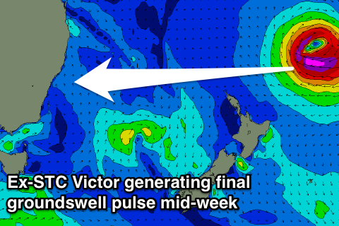
Tropical Cyclone Victor has been the talk of the town over the past week and is still on course to provide inconsistent, but good groundswell to the open beaches and points along the east coast of Australia.
We have been seeing very inconsistent sets in the 2-3ft range today, which are expected to build from 3ft+ to the 3-5ft range by later Saturday, building maintaining Sunday.
Meanwhile, a southerly groundswell which has been breaking in the 2ft+ range across the magnets today will fade, being backed up only by second very weak frontal progression. A building southerly windswell in the wake of a gusty change will easily overshadow the remnants of this groundswell by the afternoon, increasing to a choppy, low quality 2-3ft across south facing beaches on Saturday afternoon.
This southerly windswell looks to reach its peak on Sunday morning, with junky options in the 3ft to maybe 4ft range at south facing beaches.
For those rising early on Saturday, breezes look to be prevailing from the south/southwest along the Illawarra coast, lighter and more westerly further north along the Sydney and Hunter coasts. This will easily be the best time for a wave, as breezes are forecast to straighten up from the south and increase slightly throughout the day.
Open beaches will be able to snag a wave early, but options will then become confined to protected southern corners throughout the day picking off Victor sets.
Breezes still look fairly gusty on Sunday morning prevailing from the south/southwest, easing steadily throughout the day and tending southeasterly. Again, hit it early for the best results.
Next week (Monday 25th onward):
Victor is continuing along its southern track today and will continue to do so during the coming days. As it moves south over cooler waters today and throughout early Saturday, models suggest it may weaken slightly. However, during Sunday, it looks as though the system will broaden and re-intensify at a latitude of around 30 degrees, just northeast of NZ and well aligned to the Hunter coast (discussed further below).
As a result, Monday should see the swell hold 3-5ft. Most other swell sources should fade, with south facing beaches easing from the 2ft range.
Energy may ease slightly on Tuesday, with most sets in the 3ft+ range, with the odd 4 footer rolling through every so often. Tiny hints of southerly energy should also be filling in across the south swell magnets, throughtout Tuesday and Wednesday to around 1-2ft, but lacking energy.
Tiny hints of southerly energy should also be filling in across the south swell magnets, throughtout Tuesday and Wednesday to around 1-2ft, but lacking energy.
A third and final swell source also looks to develop around this period, in the form of a northeasterly windswell steered by a Tasman Ridge. This ridge looks to steer an increasing east/northeasterly airflow towards the coast, gradually increasing and tending northeasterly throuhgout Wednesday and Thursday.
As a result, we can expect a short range northeasterly windswell to build across the open beaches, reaching the 2ft range by Tuesday afternoon and increasing to 2-3ft by Wednesday afternoon.
A light/moderate southeasterly breeze is likely to persist throughout Monday swinging easterly late. Although light, this airflow may make it tricky to find a clean wave, with most breaks likely to be slightly bumpy/crumbly.
 Tuesday is also likely to see this onshore airflow continue (all associated with the Tasman Ridge) prevailing from the east/southeast along the Hunter Coast, more east/northeasterly along the Illawarra coast. Again, a clean wave will be pretty hard to come by, workable, but crumbly.
Further into the week, energy off (by this stage Ex-) TC Victor will be kick once again from the re-intensification mentioned earlier, with sets in the 3-5ft range on Wednesday afternoon, easing on Thursday.
Further ahead, we are looking at small and modest fetches sitting off Cook Strait and the far southern tip of the South Island which should provide a small mix of southeastelry and easterly swell for the days ahead.
Comments
Looks like Manly is seeing set waves somewhere in the 4ft range this morning.
Manly's looking a treat!
Pumping...no one missed the heads up absolutely packed. (yeah I know it's the w'end) You could pick up outside sets if your timing was right it seems no one likes to sit out the back anymore.
How good was this morning! Life saving contest about to take over most of Manly today... 4+ foot of east swell + clubbie equipment hopefully equals carnage.
Was pumping down the coast at daybreak but all over on the open beaches by 8am when the south wind ripped through. Into the corners now but fortunately the E swell direction is being kind to them.
stu that southerly only lasted an hour then swung back light sw... and every bastard got out... back on the pump!!!! its only really just gone southerly again. hopefully the rest of the swell is graced with such magnificent windows of good wind.
Middle-Sth Narra was pumping this morning till the southerly hit it around 9ish. One particularly large set cleaned everyone up
Central coast was clean as till about 10.30 when the southerly arrived here, but the tide and banks weren't making the best of it. Went for an arvo check around and found a spot that was open to the wind, but sideshore and bumpy rather than completely blown out, and the fast left handers on the bottom of the tide. Who woulda thunk it.
Some good clean-ups in there.
Went S/W for part of the morning but bumpy as hell from overnight wobble wind.
Banks seemed to handle the swell better yesterday. Hopefully less bods in the water tomorrow.
Local reef on coal coast was holding up well till around mid tide, but also a bit of bump
Way more consistence today
Where you based? Wasn't on the NB
Just got out from super straight closey North Steyne, fairly consistent considering on the bombs as well. 3-4ft with 5ft bombs and heaps of power/punch.
A bit further south down the beach was also dead straight however the occasional ones with a touch more north in the angle ran pretty well. (Emphasis on very occasional).
Nice! Got better with the tide this evening.
Did you travel alexsmith1? pumping no wait today upper NB Palmy Av way 5ft bombs for sure Craig dodged a couple caught a few runners and surprisingly no people out compared to NN yesterday
How's this slab at Shark Island.
I am finding this swell way over rated,its not like there will be westerly winds all day.It's onshore so who cares about the swell direction,size and period.Anyone else feel like this?
Nup. Bring it on!
It was never gonna be a banner swell - too inconsistent, funky winds - and I reckon we made that clear in the notes. I kept my expectations in check and they were matched during a few sessions at Coal Coast reefs over the weekend.
Late yesterday, however, the wind backed off opening up one of my fave waves on the coast. A wave that needs long period swell from a particular direction to show itself.
I reckon it was this, the uncommon pairing of long period and easterly direction, that animated people.
Yes Stu,a few places were ok for a short period of time.Maybe I'm becoming more fussy with conditions the older I get.
Yeah, we've not been talking it up at all Red Sands.
This morning, Manly solid 4-5ft still but too straight and winds went onshore by 8am, so not that special at all. Late yesterday was the session for me!
Meanwhile somewhere on the Mid North Coast my mate's getting ridiculously shacked..
Nice view Craig.