Victor's E/NE groundswell looking good from Friday onwards

Sydney, Hunter and Illawarra Surf Forecast by Guy Dixon (issued Wednesday 20th January)
Best Days: Friday, Saturday/Sunday at protected southern ends of open beaches and Monday.
Recap:
A southeasterly swell generated by modest fetches associated with a weak Tasman Low has been providing fun and workable options in the 2-3ft range across the Sydney, Hunter and Illawarra coasts over the past couple of days. Early offshores followed by a weak seabreeze has allowed conditions to remain fairly workable each afternoon.
This week (Thursday 21st - Friday 22nd):
Throughout Tuesday and overnight last night, a modestly sized northerly fetch of 20-30kts hugged the coast and has provided us with a small amount of northeasterly windswell today. In terms of size, it’s not much, just a weak 1-2ft across the open beaches.
A weak southerly change is due to disrupt this northerly airflow later this evening, putting a limit on the potential for any substantial windswell generation in the short term.
This northerly fetch is likely to become re-established by Thursday morning, gaining a touch more size and intensity, with duration also working to our advantage. The impacts are still only expected to be modest, with open beaches picking up peaky short range windswell in the 2ft range, perhaps building to the 2ft+, maybe 3ft range with slight intensifications and improving alignment throughout the day.
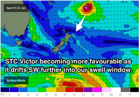 Thursday should also start to see the first signs of a very long range east/northeasterly swell generated by Severe Tropical Cyclone Victor. Victor has been lingering over the tropical South Pacific over the past few days and is forecast to move in a southwesterly direction, becoming more favourable for the NSW coast.
As this system drifts southward into the swell window, we expect to see more size as a direct impact from Victor as opposed to just sideband energy. Furthermore, we should also see consistency improve as this system edges closer to the mainland.
East/northeasterly groundswell is not expected to be anything substantial of Thursday, building to an inconsistent 1-2ft by the afternoon.
The best chance of a clean wave will be early, under a light northwesterly breeze. By mid-morning, all coasts look to be under an increasing northeasterly seabreeze.
Friday should see more substantial groundswell from Victor, building to the 2-3ft range across the open beaches.
Meanwhile, we should also see the peak in northeasterly windswell on Friday morning thanks to northerly breezes which persist throughout the night. The southern half of this northerly fetch should gradually move offshore on Friday whilst persisting throughout the day north of Sydney.
Open beaches are expected to peak in the 2-3ft range, with winds looking favourable.
The third and final swell in the water looks to favour south swell magnets, generated by a poorly aligned, but fairly strong frontal progression which is due to move over the Southern Ocean on Thursday. South facing beaches can expect inconsistent sets in the 1-2ft range.
Preceding a southerly change due on Saturday, breezes look to be light for the majority of Friday. Initially, we are looking at a light northwesterly airflow, remaining light with weak seabreezes developing throughout the late morning and afternoon.
Waves should be clean, if not easily workable for the majority of the day, with some models even picking afternoon offshores.
This weekend (Saturday 23rd - Sunday 24th):
East/northeasterly groundswell is only set to build throughout the weekend as discussed earlier, providing sets in the 3-5ft range on Saturday and Sunday.
Subtle ebbs and pulses of southerly energy generated by very small but very intense fetches off the ice shelf of Antarctica during Thursday are expected to fill in across the weekend, maintaining very inconsistent sets in the 1-2ft range across the south swell magnets.
Finally, a very small amount of southerly windswell is due across exposed beaches following Saturday morning’s change, but really only to around the 2ft+ mark. South facing beaches will merely be choppy on Saturday, with the only option for a clean wave falling in the early morning where winds look to tend south/southwesterly. Protected southenr corners of the open beaches will be the way to go.
Similarly, Sunday should see an early southwesterly breeze, tending light southeasterly as the day wears on. It’s still worth keeping it to the southern corners of the open beaches throughout the day to pick up workable sets of our mate Victor.
Next week (Monday 25th onward):
Local swell sources the following week look to become virtually non-existent, with only easterly groundswell continuing from Victor. Open beaches are expected to continue seeing solid sets in the 3-5ft range on Monday and Tuesday.
A light southeasterly breeze looks to continue on Monday, so protected southern corners and points will be the way to go. Options at these locations have the potential to be really fun once the weekend crowd drops.
Tuesday is also looking at a light onshore flow, with a small amount of discrepancy between models, some saying light southeasterly, some saying light northeasterly.
More detail to come on Friday.
Comments
hey guy, whats with the 8ft+ E swell forecast for the 30th?
That means it will be 8ft pumping East swell on the 30th Oiley.
Latest model run is picking the southern extension of a deep trough to push offshore on Friday 29th/Saturday 30th sending a stiff E'ly into the coast.
At this stage, take it with a grain of salt. It's one of the runs to pick anything, so still very early days. May firm up if another model jumps on the band wagon. Just too early to call with any certainty.
cheers
Gotta love the SN pro bro;)
Keep an eye on it Oiley........
:) thanks mate
Is it still on course to get here?
Are you referring to the 8ft E swell on the 30th?
Models adjusting timing, position (and liklihood for that matter) of the trough/low developing. A lot of model variation so don't get your hopes up just yet.
Yea we haven't had anything that big from that direction for quite some time.
how come the Sydney-Illwarra forecast notes never froth out as hard as the SEQLD/NENSW notes?
Is everyone too apathetic too care down there?
notes=comments.
Frothin inside freeride. Still haven't worked out where I will be, subject to negotiations when I get home tonight.
May have an unexpected longer stay up the coast than just one day.
As commented on the other site, it's not the sort of swell that will handle a crowd, so being judicious in where to go is worth the effort.
Would be interested to know where Craig is headed, and I suspect Stu will be out the front, but maybe earlier than he was planning.
Inconsistent 3'-5' waves with suspect winds?
I'd rather go rollerblading.
Safer ay Stu ;)
Have you ever been in the water freeride with pack of 12 yo bodyboarders, on a sucky 2ft day. They hoot and holler and yell at each other to charge, they even get all doey eyed when they see you head dip a nice one, and tell you as you paddle back out how epic it is. Well, that's what it's like surfing the Swellnet with NNSW / SE QLDers. Hehehe
Well the thing is that everyone in Sydney are too cool for school to get
excited about the surf. Just like nobody will ever say the waves are over
8ft because they think everyone will call them on it and make them the fool.
Funny thing is the so called hardest place in the world to surf Hawaii everybody
hoots and praises if someone gets a good bomb. Go figure
I agree with your sentiment evo, but I disagree with crowd behaviour from those areas. I see a bunch of enthusiastic punters and stone faced heros in all sessions all over the place. Probably worse in SE QLD than Sydney if anything.
I was just having a joke with ya, more of a state rivalry thing than anything else. I was hoping to stir up a comment from free, him being of far sharper wit than myself, purely for the fun of a debate. Truth be told, I tend to read the comments first then the article second these days, particularly the qld forecast. Froth on, it gives me something I care about to read on the commute home from Sydney
hahahah, your comeback was of such a high quality it deserved to sit there unmolested.......I was just trying to get a rise out of Stu or Craig.
Tues was bang on south swell magnet no one in water top to bottom solid 3-4 (long wait)off shore & summer in Sydney was wondering what had happened....keep up the good forecast work Guy.
Looking forward to this swell I love east swell just might have to go north to a place that loves south suspect winds Stu! Better than 1ft n/e windslop.
Hard to tell if it was in the water down here.
Swell wasn't peaky short-spaced NE windswell and more longer-lined 2ft sets but fairly inconsistent.
Breaking on the high tide all the way from out back to inshore, complete contrast to yesterday's weak 2ft junky NE windswell.
So I'm to believe some of it is in the water here.
Yeah just had my son in at south narra trying to get inside runners and BOOM front runners...old mate from WA speaking to on the beach has been here for a week and going home tomoz ah well at least she wasn't a mill pond.
BTW Steve, it's hard to park within a mile of a beach in Sydney at the moment.
I'm just waiting for the storm to come over to head down to the beach for a dip. Hopefully it will clear the beach.
Schools back next week, at least that will cut the crowds during the day.
Looks like both the small E'ly swell and S'ly swells are producing fun waves across the Sydney coast this morning, albeit very inconsistent at times.
See Manly (E'ly swell) and Bondi (S'ly swell):
Almost turned around at dawn due to a lull, got some nice ones but with a very full tide having a big impact.
yeah same in the illawarra, the full tide took the edge off - and southerly winds? go figure
What happened to that 8ft E Swell on the 30th?
Models adjusting timing, position (and liklihood for that matter) of the trough/low developing. A lot of model variation so don't get your hopes up just yet.
Haha, lets deal with the coming swell first :p
Couple of nice lines at Maroubra.
Definitely in the water here (central coast). 2 - 3', irregular, with a couple of 4' breaking top to bottom, on my head of course.
Oily smooth surface, but in spite of that it didn't amount to a great surf. Favourable banks would be a handy thing.
Glad I left Maroubra in the rear view mirror. :-) Average crowd, and omg, a SUP, at the 'bra.
Breakfast and a scout around now.