Small clean waves Thurs/Fri, ahead of an excellent weekend

Sydney, Hunter and Illawarra Surf Forecast by Ben Matson (issued Wednesday 30th December)
Best Days: Thurs/Fri: fun clean waves across the beachies. Sat/Sun: building E/NE tending E'ly swells with favourable winds on Sat and Sun AM. Tues/Wed: mix of strong E/NE swells, and possibly an ECL.
This week (December 29th - January 1st)
Thursday should deliver some great waves. The incoming sideband SE swell due late today is expected to hold through Thursday with sets in and around the 3ft mark at south facing beaches, perhaps a little bigger across the Hunter coast but smaller at those locations not completely open to the south. A slight easing trend may occur into the afternoon.
Local winds should remain light and variable under the influence of a weak pressure gradient, so although there’ll be sea breezes we shouldn’t see too much strength.
On Friday, the SE swell will ease back a touch though should still produce fun waves at most open beaches. In fact, the swell direction should shift more E/SE during the day, owing to the strong ridge occupying the Southern Coral Sea and Northern NSW/SE Qld coasts. It’s generating a strong local swell for that region but we should see a small degree of spread back our way, which mixed in with the residual SE swell should continue to produce fun 2ft+ waves across most open beaches, with a few bigger sets in the Hunter again.
Local conditions should remain clean with light offshore winds and light to moderate afternoon sea breezes.
This weekend (January 2nd - 3rd)
Looks like a very active weekend ahead of all East Coast surfers. In fact the next week and half should produce an extended period of excellent waves for many locations.
As mentioned comprehensively in Monday’s notes, a large low pressure gyre across the Tropical South-western Pacific Ocean is generating several new easterly swell sources for the Australian East Coast. The first is expected to spin up south-east of New Caledonia today, with easterly gales feeding into the trough line across the Tasman Sea. This is expected to consolidate with a northward-moving mid-latitude low in the Central Tasman Sea - the same one responsible for the new SE swell due later today and tomorrow.
This consolidation is expected to result in a broad low pressure system across the Northern Tasman Sea throughout Thursday, by which time its easterly fetch should be well established, and generating strong swells that are due to arrive sometime early Saturday, before peaking later in the day or early Sunday.
At the moment, I think the models are undercooking the size of this event - they’re estimating a building trend to 3ft late Saturday, then 4ft throughout Sunday. However, the consolidation of the tropical low (warm cored) and the mid latitude low (cold cored) is often underestimated by computer models, and I think we’ll end up seeing stronger surface winds than the current guidance is suggesting (35-40kts).
Additionally, the broader system is moving slowly south-west, and the developing lows within are expected to push slightly faster to the west (almost slingshotting around the parent), which should set up a captured fetch scenario - which essentially generates bigger, stronger swells than the theoretical maximum. They'll also be working on quite an active sea state generated by this week's strong S/SE swells.
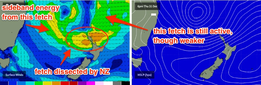
Lastly, a second swell source is expected to develop from this same pattern but in an unusual manner. As the broad low tracks south, the easterly fetch along its southern flank will end up being dissected by the North Island of New Zealand. Therefore, the easterly winds extending west of the North Island later Thursday and Friday don’t seem to be adequately captured by the wave models (probably due to the short length).
And at the same time, a broader SE fetch aimed up into the Coral Sea should still be generating some small but useful sideband energy for us around the same time too.
So in short, I think we’ll see more size than the model is estimating. Early Saturday morning will probably start off with residual energy from Friday, but should build in size all day from the E/NE, reaching somewhere between 3ft and 5ft at NE facing beaches by the late afternoon (smaller at south facing beaches). Sunday should continue in a similar size range - maybe a little more consistency in the upper end of this size range - and with the swell direction swinging more to the east.
As for local conditions - light winds and sea breezes are expected on Saturday, whilst a ridge moving south of the state on Sunday will probably freshen easterly winds into Sunday afternoon - though the morning should remain light and variable again. So all in all, it’s shaping up very nicely.
Next week (January 4th onwards)
Current model guidance maintains a mix of east swells through Monday in and around the same size as we’re expecting on Sunday. There’ll be a new source in the mix through - a firm ridge across the Central Tasman Sea, generating peaky short to mid range energy, along with a freshening E’ly wind. So at this stage Monday doesn’t look great mainly due to the onshore winds. A small change in the local synoptic pattern could swing this poor outlook about-face though.
I’m still keeping an eye on additional tropical developments within the large low pressure gyre across the Tropical South-western Pacific Ocean. TD05F is current west of the Cook Islands and is expected pass south of Samoa tomorrow, and will probably develop into a Tropical Cyclone.
This system is then expected to continue meandering westwards towards Fiji (which may cause some problems locally around Jan 2/3/4), all the while with a strong trailing fetch extending south to New Zealand latitudes.
This should set up a strong secondary E/NE groundswell arriving around Tuesday, building up towards a strong, albeit very inconsistent peak in size somewhere in the 4-5ft range at exposed beaches (maybe Wednesday), before easing slowly through the rest of the week.
Additionally the long range models are suggesting we’ll see a deepening coastal trough across NSW early next week that could very well eventuate as an East Coast Low - and a subsequently large local swell by Tuesday afternoon or Wednesday. But that’s still a long way off yet - more to be discussed on Friday.
Comments
It's mentally packed with surfers, swimmers and punters at Bondi - I don't know how anyone can surf there.
But sets are still around the 3ft mark.
had a similar (although to a lesser extent) scenario around wollongong today, but it was great because nobody could get a park, surfers included. after i finally got one i got a usually packed spot to myself. thanks sydneysiders, your welcome down here anytime. just leave your board at home haha.
yeah the crowds thin out a little just south of the gong, but still hard to find a bank to yourself
haha classic bondi.
today for the arve sesh I shared 3-4" offshore Waitpinga with a school of salmon (keeping the locals well fed) and a bunch of fishos on the beach. no one else.
it's been the same since Christmas.
hopefully that east swell turns up for late next week for my return to Sydney.