Fun mix of peaky swells this week; better E/NE swell prospects this weekend onwards

Sydney, Hunter and Illawarra Surf Forecast by Ben Matson (issued Monday 28th December)
Best Days: Wed PM: a'noon pulse of new S/SE swell, easing Thurs with mainly light winds. Sat/Sun: fun, quality E/NE swell. Mon/Tues/Wed: rebuilding E/NE groundswell, possibly of a decent size.
Recap: Peaky NE swell on Saturday, with building S’ly swells on Sunday in the lee of a gusty change. Surf size is easing today though conditions are still very ordinary with poor winds (a brief period of SW winds occurred around dawn this morning, cleaning things up for the mid-morning session, but they’re back around to the S/SE again this afternoon).
This week (December 29th - January 1st)
The current short range S/SE swell originating from a broad ridge stretching from the Coral Sea down to the south-eastern Tasman Sea will ease through Tuesday as the fetch weakens today. Local winds should also abate somewhat, which should allow for longer periods of light SW winds in the early morning (though, this is less likely across the Hunter).
As such, we can expect peaky surf easing from 2-3ft to 2ft at south facing beaches on Tuesday, with maybe a few bigger waves in the Hunter. Reasonable standard summer peaky surf, nothing to get too excited about but certainly providing options at open beaches.
A new Tasman low is currently forming along the trough line in the Southern Tasman Sea today. It’s expected to meander throughout the region for some time, before tracking northwards throughout Tuesday. This system won’t be perfectly aligned for our region, but as its fetch will be working on an already active sea state, it will take less effort to kick up a decent groundswell - of which we’ll see some sideband energy glancing the coast throughout Wednesday, probably from lunchtime onwards.
Our swell model isn’t picking up this system very well at the moment, and I think we’re going to see some really fun waves across the coast, assisted by a light/variable airstream under a weak pressure gradient. South facing beaches should pick up occasional 3ft+ sets from this swell throughout Wednesday afternoon (smaller in the morning), with a few bigger waves across the northern Hunter coast. However, beaches not open to the south will be much smaller so keep this in mind when choosing a location.
Wednesday’s swell should peak overnight before easing through Thursday; initially some 2-3ft sets across south facing beaches in the morning, with the swell direction tending more SE, and smaller surf into the afternoon. Light variable winds and sea breezes should keep conditions clean before lunch.
On Friday we’re mainly looking at small residual SE swell across most open beaches, and light NW winds ahead of a moderate NE sea breeze.
This weekend (January 2nd - 3rd)
This week, we’re expecting some substantial developments to take place within our far E/NE swell window.
As I’ve been discussing for the last couple of weeks in the SE Qld forecast notes, we have an active monsoon pattern across the top end (though it hasn’t spawned a Tropical Cyclone in the Gulf of Carperntaria, as has been expected). Additionally, a second region of vigorous north-west monsoons are moving eastward across tropical waters north of Fiji (broadly between PNG and about the Cook Islands).
The latest model guidance suggests a developing blocking pattern upstream from this, which is in turn expected to instigate an enormous low pressure gyre across the Tropical South-western Pacific Ocean. That is, a clockwise conveyer belt of storm activity tracking east through the equatorial regions, then south down towards New Zealand, then back west towards the Australian mainland before turning north into the Coral Sea.
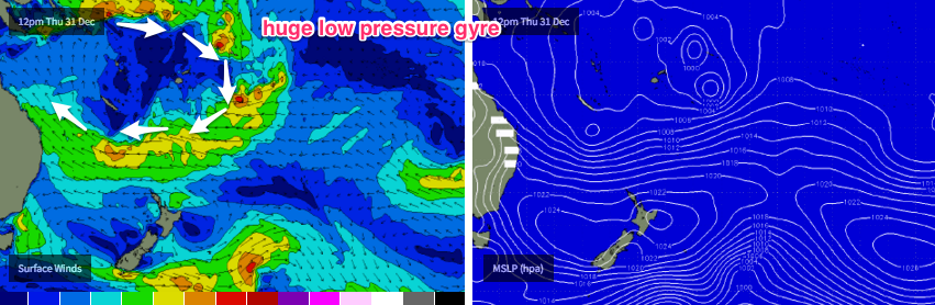
And the implications of this is a good chance for a fantastic, sizeable and long lived easterly groundswell for the longer term period right across the East Coast. In Southern NSW the swell direction will be more E/NE due to the more northern position of the fetch.
What I like most about the developing E’ly fetch is its impressive length - almost the same as the width of continental Australia - and its slow westward track, which is unusual for a swell generating system of this size, in this ocean basin.
Whilst wind speeds within the broader system aren't modelled to be radically strong, a couple of embedded low pressure troughs nestled inside the primary fetch will display higher strength than those surrounding (likely south of New Caledonia late Thursday) and these should be the main contributor to the peak wave heights of the swell cycle.
Right now, it’s a little hard to pin down the specifics (size, timing) for the weekend’s event but it looks like we’ll see an upwards trend throughout Saturday and probably an easing trend on Sunday. Set waves should reach 3-4ft at most open beaches at the height of the swell, some exposed swell magnets may see occasional 5ft sets. And at this stage we’re not expecting much of a gradient wind, just light variable patterns and sea breezes.
Let’s fine tune the details on Wednesday - but for now the weekend’s looking quite promising for much of Southern NSW.
Next week (January 4th onwards)
Over the weekend, a second impressive E’ly fetch is modelled to be taking shape even further east, well to the SE of Fiji, and contained within the same broad tropical low pressure gyre mentioned above.
This secondary fetch looks like it could end up being equally strong, broad and slow moving as the fetch responsible for our expectant Sat/Sun swell, however it will be located much further away from the mainland so wave heights will be a little smaller at the coast than the previous event (though, if winds end up being stronger, this could tip the balance in favour of a similarly sized swell event, or higher).
Early indications are for a gradual rebuilding trend throughout Monday with Tuesday and Wednesday seeing another round of strong E/NE swell in the 3-5ft range at exposed beaches.
After this, it’s likely that easterly energy will abate only slowly across the region, so extrapolating this forward and I’d be surprised if there wasn’t at least some small useful E/NE swell across the region all the way up until the following weekend. For reference, our current model run has this holding 3-5ft between Mon and Fri (and even bigger at times!) though I think this is overly optimistic right now. Regardless, it’s a great synoptic pattern for the long term that should deliver some nice waves for those of you enjoying the Christmas holidays.
See you Wednesday!
Comments
Fun looking lines at Bondi this morning.
Manly looking the goods this afternoon.