Southerly swell holding for most of the week

Sydney, Hunter and Illawarra Surf Forecast by Guy Dixon (issued Monday 23rd November)
Best Days: Tuesday morning, Wednesday early and Thursday preceding a southerly change.
Recap:
It wasn’t a great weekend. Saturday offered surf in the 2-3ft range, impacted by a fresh southerly breeze, slightly larger across the Hunter. Sunday was a slight improvement with a touch more size and a lighter east/southeasterly breeze.
This morning has easily been the highlight of the past few days.
There have been some great options along the coast today with a solid southerly groundswell moving up the coast. Most coasts have been offering sets in the 4ft range throughout the morning, building further this afternoon with bomb sets in the 6ft range at exposed south swell magnets. Unfortunately, breezes have swung southerly so protection is now needed. Still, there is some good long period energy getting into the protected spots.
This week (Tuesday 24th - Friday 27th):
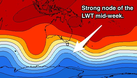
An intensification embedded within a broad and elongated frontal progression which moved south of Tasmania on Sunday will maintain good southerly energy for Tuesday, although not quite as strong as today. Nevertheless, south facing beaches can expect the periods to hold in the 14-15 second range with sets in the 3-4ft range in the morning, fading gradually throughout the afternoon.
The southerly airflow which is impacting the coast this afternoon will also add a small amount of short range energy into the mix, peaking overnight. In the early hours of Tuesday, there should be around 1ft of insignificant southerly windswell in the water, fading rapidly and likely overshadowed by the more dominant groundswell.
Light south-west breezes are on the cards for Tuesday morning, becoming variable and swinging northeasterly throughout mid-morning. These northeasterly breezes are likely to increase in the afternoon, earliest and strongest over the Illawarra generating a small northeasterly swell of low quality for the open beaches.
Another strong front is looking to move across the Southern Ocean this evening. This long range system is likely to produce yet another pulse of southerly groundswell which is expected to fill in on Wednesday morning, building to the 3ft+ range at south facing beaches by the afternoon.
The morning session looks good with winds forecast to be light northwesterly along the Sydney and Hunter coasts, more north/northwesterly along the Illawarra. Northeasterly breezes will soon increase limiting options to protected northern corners where the southerly swell will be most obvious.
Open beaches won’t miss out with a northeasterly local fetch increasing along the majority of the NSW coast throughout the day. By the afternoon, open beaches should be offering peaks in the 2-3ft range, although likely choppy and lacking order.
This northeasterly swell is likely to peak in the early hours of Thursday, particularly along the South Coast where open beaches could see peaks in the 4ft range. Further north, the impacts of this northeasterly swell will be less.
A southerly change is due during the day on Thursday (still some model disagreement) but either way we are looking at a morning of northwesterly winds preceding the change.
Open beaches have the potential to pick up fun a-frames in the morning, while south facing beaches can make the most of Wednesday’s southerly groundswell fading from the 2-3ft range.
As the southerly change moves through, protected southern corners of open beaches will then be the pick.
Friday’s conditions look generally pretty ordinary with a sizey, but low quality southerly swell generated by the change on Thursday. South facing beaches should peak in the 3-4ft range, while open beaches can expect a fading northeasterly swell from the 1-2ft range. Local winds look to prevail from the south/southeast while easing so conditions won’t be all that great.
By this stage, you should be well and truly surfed out.
This weekend (Saturday 28th - Sunday 29th):
A lot of the significant swell generators dry up leading into the weekend as the long wave trough becomes less pronounced over eastern Australia. Frontal activity is likely to decrease with only small 2ft+ waves Saturday, fading Sunday.

There will however be a very small amount of east/northeasterly energy in the water from a depression over the Tropical South Pacific which is looking to deepen mid week. The effects from this system are only expected to be subtle over the weekend, in the 1-2ft range for Saturday, slightly larger on Sunday.
Next week (Monday 30th onward):
There is a fair amount of variability regrading the aforementioned depression, however there is the potential for a touch more size early next week from the east/northeast to around 2-3ft. More on this Wednesday.
Comments
Today not april fools day I just left wanda which sucks in south swell and its lucky
to be 2ft. I don't get it.
You are not alone It was quite bizarre on the Central Coast, I checked one beach that was solid 6', then headed to a another and it was 1' maybe 2' at best, then headed to another well known spot and again it was 6', so we headed to one of our regular uncrowded semi secret spots and again it was a disappointing 1' to 2' even though the bombie out to sea was firing off at around 8', the only thing we managed to achieve after all that was spending around $20 each on petrol!
Weird one mate - sounds like a case of magic numbers (something I'm fascinated in and am doing some research on the side about).
Swells of different directions and periods are steered into specific parts of the coast, according to the local bathymetrical profile. For example, there are a bunch of locations that are usually 'reliable' swell magnets under certain directions (i.e. Cronulla under a south swell). But sometimes, under specific conditions (ie particular period/direction combos), these south swells can be steered away from the usual swell magnets and into another coastline.
We see it happen across all coasts at some point in time, and this may be the underlying reason for Cronulla's under-performance today (as we've seen occasional 4ft+ sets on the Bondi surfcam this afternoon, a nearby south swell magnet).
Cronulla sucks why do surfers go there.
Spot on Ben. I've noticed roughly 4ft + 15sec + 170deg to be the magicical disappearing swell combo for cronulla.
Add size or more south and it's back into the magnet zone.
Very interesting, especially with numbers to back it up!
Yeah Guy. I've sat out vooee too many times wondering why the swell wasn't getting in and then later, comparing notes with my mate Longy up at Foresters which had double the size. Today I'd guess it was pulling in 5-6 foot today albeit onshore.
Nice lines at Bondi this morning.
Surfed Queensy and while inconsistent sets were solid 3ft, with a couple of 4ft bombs. Cronulla missing out again, and only reported at 2-3ft.
surfed and observed spots ranging between solid 4 and 8 foot today. macking swell, consistent and punching well above the forecast. comparing last weeks (monday i think?) when i surfed and observed the same spots and they were barely 2 foot and horribly inconsistent. today according to swellnets forecast figures it was 0.7m 189degrees at around 15 seconds, last monday was 0.4m 189 degrees around 15 seconds. obviously it was the quality of the storm and origin which affected it so much but they were interesting observations. i would love to study up on surf meteorology (is that the right word) rather than reading figures from the charts because they only paint about 1/4 of the picture in my opinion. cheers guys u do a great job.
Wow, great info mate. What coast are you on?
are we still on track for 3ft+ at SF beaches this arvo?
I was just about to ask that. Thanks for another great forecast Guy.
I'm inclined to downgrade this afternoon's swell pulse just a touch. South facing beaches should be offering 2-3ft options, potentially 3ft at the exposed magnets. This swell has a bit more west in it due to the way the storm track deceloped, so it's a tough one. Unforuntately the buoys south of Sydney aren't giving us much helpful info either.
Having said that, there are 3ft sets breaking across Bondi atm.
thanks guy - nice afternoon for a paddle anyway, the low tide should help too
Cheers Guy!