Mix of swells mid week, potentially building into the weekend
Sydney, Hunter and Illawarra Surf Forecast by Guy Dixon (issued Monday 16th November)
Best Days: Tuesday morning, Wednesday and Thursday morning.
Recap:
A mix of swells provided a small amount of surf across the weekend, although winds were on the dicey side. A northeasterly windswell did well to provide peaks in the 2ft range at open beaches throughout the weekend. Without it, the scenario would have been a lot worse. The second swell in the water was a southerly groundswell which provided surf in the 2ft range on Saturday along south facing beaches of the Sydney/Illawarra stretch and the in the 2-3ft range on Sunday. The Hunter gained a touch more size, as usual, however these exposed locations were pretty ordinary as a southeasterly breeze persisted virtually all day each day. More protected southern corners had smaller workable options.
Today the surf has been holding in the 2ft range for Sydney and the Illawarra predominately off the remnants of the southerly groundswell, while the Hunter is offering surf in the 3ft range. A southeasterly breeze is continuing to take the shine off conditions however.
This week (Tuesday 17th - Friday 20th):
A deep low pressure trough which generated all that rain over the east coast on the weekend has moved offshore and is interacting with a building high pressure ridge over the Tasman Sea. As a result, a relatively weak, but elongated southeasterly fetch has been working over central and northern parts of the Tasman since Sunday, whipping up an easterly swell for Tuesday.
Open beaches will fair the best off this trickle of easterly energy, with surf in the 2ft range in the morning, fading slowly throughout the day. Residual southerly energy which we have also been taking advantage of across the weekend will also gradually fade from the 1-2ft range.
If Tuesday is your only opportunity to get in the water, it’s certainly worth making the effort to get out of bed for the early session as winds will be at their most favourable at that time. A light northwesterly breeze will dominate in the morning, before soon turning northerly and eventually northeasterly while increasing. Not only will the surface bumps increase throughout the day, but the swell will be on the downward trend, so hit it early to gain the most energy.
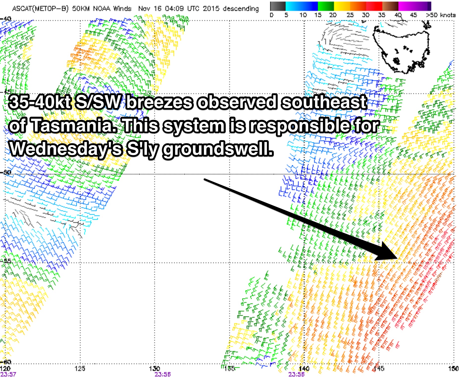
 Wednesday will see a fresh southerly groundswell fill in across south facing beaches generated by a front which is currently moving over the southern Tasman/Southern Ocean. Southeasterly fetches trailing this front, although not perfectly aligned look much better than what we’ve been seeing in recent times. This system is set to whip up a southerly groundswell with periods in the 14 second range. Size wise, south facing beaches should hold in the 2-3ft range throughout the day. Also in the mix will be the easterly swell from the day before, although easing from the 2ft range throughout the day at open beaches. A tiny northeast windswell will also be breaking generated by Tuesday afternoon's gusty northeasterlies, but likely undersized.
The morning session is looking good under a light northwesterly flow, with winds looking to remain light over the coast throughout the late morning. At this stage, an afternoon seabreeze is only looking like a low chance, more likely just tending light northerly. In either situation, we can expect light winds and generally clean conditions until early-mid afternoon preceding a southerly change due in the evening.
The southerly breeze is looking to be fairly weak and brief, with winds likely to be light/variable offshore by Thursday morning. Southerly energy will continue to break across south facing beaches however smaller in comparison to the day before. Exposed locations are likely to ease from the 2ft range. A northerly breeze will increase in the afternoon, so the beaches with all the size will also be the cleanest.
A trough is set to sweep over southeastern parts of Australia late on Thursday, along with an associated low moving south of Tasmania. Southeasterly fetches moving east of Tasmania, in addition to southerly trailing fetches are expected to generate a southerly swell increasing throughout Friday to the 3ft range at south facing beaches in the afternoon. Models are struggling to agree on the wind pattern for Friday however. Some models indicate offshore breezes all day, which would also lead to a particularly hot day along the coast (more likely scenario) while others are picking a northeasterly flow leading to ordinary surf conditions.
This weekend (Saturday 21st - Sunday 22nd):
One of the more interesting parts of this forecast is that Thursday afternoon’s scenario looks to virtually repeat itself soon after.
A second trough and embedded low should deepen over the nation’s southeast on Friday evening, moving off the far South Coast of NSW in the early hours of Saturday. Southeasterly core fetches of around 35-40kts are looking more defined and moving more locally.
As a result, we expect to see a strong increase in short range southerly energy to the 4-6ft range on Saturday afternoon, with the potential for more size on Sunday.
It’s worth mentioning that there is a fair amount of model uncertainty between two front running models, particularly in terms of the airflow pattern. At this stage it’s virtually impossible to back a scenario with any confidence, so I’ll leave the details for later forecasts.


Comments
G'day guy, would it be a safe assumption that the southerly change for tomorrow will hit ulladulla area around lunch time? Cheers mate
Yes, I'd say lunchtime or just after.
thanks alot mate
hi Guy, whats the confidence level on this new S groundswell being in the water early am tomorrow?
Good confidence, but the peak looks to around the middle of the day. Looking at 0.5m at around 14 seconds during the day.
hi Guy, whats the confidence level on this new S groundswell being in the water early am tomorrow?
Hi Mate,
0.5 still translate to 2-3 ft?
Magic Seaweed and Coastalwatch aren't picking up anything in this realm (mind you, they usually aren't as accurate as you blokes).
Yeah I'm still thinking 2-3ft due to the long periods. There may be a bit of a wait between the bigger sets however.