Dynamic week ahead, probably best Friday morning

Sydney Surf Forecast by Craig Brokensha (issued Monday 2nd November)
Best Days: South facing beaches Wednesday, Friday morning, Saturday morning protected southern corners
Recap
A good mix of S'ly groundswell and building NE windswell Saturday with 3ft sets across south facing beaches and building 3ft peaks later in the afternoon across north-east facing beaches. Conditions were best in protected northern corners though with a fresh to strong NE wind.
Come Sunday the NE windswell was the most dominant of the two, with good 3ft peaks across north-east facing beaches but again with less than favourable winds.
Overnight thunderstorms and rain signalled the movement of a surface trough offshore, bringing cleaner conditions and light NW winds this morning but smaller and easing 2-3ft levels of NE windswell. A shallow SE change is due mid-late afternoon as the windswell continues to ease.
This week (Nov 3 - 6)
While the bulk of the NE fetch responsible for the last couple of days of NE windswell has moved out of our swell window, a lingering N/NE flow off the Mid North Coast will keep small 1-2ft sets hitting north-east swell magnets tomorrow morning.
A weak S/SE swell is also due to build through the day, generated by a stronger fetch of S/SE winds at the base of this afternoon's change, although this isn't expected to top 2ft later in the day, easing back from a similar size Wednesday morning.
Also in the mix Wednesday should be an inconsistent long-period S'ly groundswell from a short-lived fetch of storm-force S/SW winds south of Tassie yesterday and last night. This should fill in through the morning and reach a good inconsistent 3ft to possibly 4ft across south facing beaches, peaking into the afternoon, with larger sets in the Hunter.
Winds tomorrow are a little funky, and will likely be lingering from the S/SE offshore, but tend S/SW on the coast through the morning favouring southern corners before an afternoon E/NE'ly. Wednesday will then see variable breezes, strengthening from the E/NE through the day.
From Wednesday we've got quite a dynamic and exciting forecast, with a deepening inland surface trough across the south-east of the country set to producing a strengthening infeed of E/NE tending NE winds off the southern NSW coast.
 As this trough starts to deepen Wednesday, a strong fetch of E/NE winds to our east should kick up a building E'ly swell which is likely to reach 3ft+ later in the day across open beaches (larger on the South Coast) but with those strong E/NE winds.
Overnight gale-force E'ly winds strengthening over an already active sea state should produce larger levels of E'ly swell into Thursday coming in at 3-5ft across Sydney beaches (a touch bigger across the South Coast), tending more E/NE during the day as the fetch starts to take a more NE alignment.
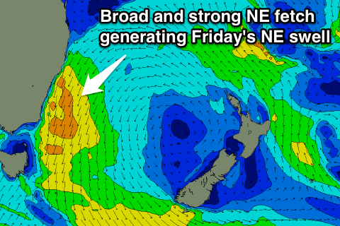
With the fetch swinging NE and strengthening through Thursday afternoon and evening, we'll see a solid NE windswell generated for Friday coming in at 3-5ft across north-east facing beaches in Sydney and 6ft+ on the South Coast.
Strong onshore NE winds on Thursday are due to swing N/NW to NW on Friday as the trough/low starts to move offshore, resulting in improving conditions and a slow drop in size through the day.
A stronger S/SW tending S/SE change is due on Saturday, with the NE windswell easing back from 2-3ft across north-east facing beaches, overpowered by a building S'ly windswell into the afternoon. Now the size of this swell is still a little undecided as the models diverge on the strength and structure of the change, but we're probably looking at 4-5ft of swell, tending more S/SE and then SE through Sunday and Monday while slowly tailing away.
With this model divergence, even regarding the size of Thursday's E'ly swell, you'll have to check back here Wednesday for a clearer idea on what's in-store for the rest of the week.
Comments
Does anyone know if the buoys are playing up with readings? They read predominantly south/se swell all weekend but from our local headland it was clearly more north east in direction as you forecast.
Mibs, yes, since the spectra graph has been updated it hasn't been working well at all.
NE swells hardly appear and the energy is always from the SSE. The line graph is a better representation for direction, we've contacted MHL about the issue.
I did notice the line graph dropped under 90 degrees (checked early today at previous records)
I thought my weetbix weren't soggy or something