Fading S'ly swell with bits of NE wind swell thrown in

Sydney, Hunter and Illawarra Surf Forecast by Guy Dixon (issued Friday 30th October)
Best Days: Saturday morning, Sunday morning and Wednesday morning.
Recap:
Thursday morning offered good conditions along the Sydney and Illawarra coast with clean options in the 3-4ft range under light/variable-offshore breezes.
The early risers for Friday morning awoke to a touch of morning sickness, but conditions soon cleaned up under westerly breezes (models performed poorly, picking N/NE breezes the night before) with pumping surf in the 3-4ft range, with the occasional bigger set at south facing beaches.
This weekend (Saturday 31st - Sunday 1st):
The early stages of the weekend are looking fun with inconsistent southerly energy filling in from poorly aligned and weak frontal progressions.
We are likely to be left with inconsistent peaks in the 2-3ft range on Saturday, slightly larger across the Hunter.
The Hunter is likely to see the best conditions as northerly breezes dominate in the morning. Breezes also have the potential to tend north/northwesterly along the Wollongong stretch, otherwise, northern corners of south facing beaches be the best options under this wind and swell combo.
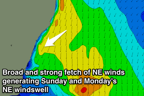
Earlier in the week, models were suggesting that a northerly flow was going to increase along the coast on Saturday afternoon and persist throughout the night providing a northeasterly wind swell by Sunday morning. When Wednesday’s notes were published, the models had steadily dialled down this swell generator, however, now they have ramped it back up again.
It doesn’t look as strong as it did originally, however I would expect open beaches to offer peaky 3ft surf on Sunday, while south facing beaches continue to pick up small southerly background energy in the inconsistent 2ft range.
The morning session will be the pick of the weekend under a light northerly flow which has the potential to tend northwesterly at times. Conditions should soon deteriorate however under an increasing northeasterly flow.
 Next week (Monday 2nd onward):
The northerly airflow responsible for Sunday’s peaks surf will shift offshore while it’s alignment deteriorates. As a result, the surf should fade from the 2-3ft range throughout Monday across north-east facing beaches. On the plus side however, conditions are expected to be clean right along the coast until late morning/early afternoon under a west/northwesterly breeze preceding southerly change.
The best part of Tuesday is also likely to lack size and energy, with a small short range southeasterly swell in the water generated by the aforementioned weak change. We’ll be lucky to crack the 2ft mark in the morning, however the first hints of a southerly groundswell may offer a touch more action in the afternoon.
As for breezes, conditions won’t be anything special under a light/moderate south/southeasterly breeze tending easterly, however it could be worse. If you’re happy to work with a few bumps and soft lips, then you should be able to find a few options.
Core fetches associated with a deep low and frontal progression over the Southern Ocean are set to move into the NSW swell window throughout Sunday, while strengthening. The core fetches of 45—50kts have eased a touch and aren’t particularly broad, however the alignment is looking quite good, and there is plenty of potential off southern quadrants of this system also.
The bulk of this swell will move up the coast on Wednesday morning providing surf in the 3-4ft range at south facing beaches, larger across the Hunter. A small amount of wind swell will also be in the mix as local breezes swing through to the northeast.
Hit it early for the best conditions as light winds prevail from the northwest. As the day progresses however, a gusty northeasterly breeze will increase limiting options to the most protected north ends of a south facing beahes. This will also increase your chances of picking up energy off the southerly groudswell.
Thursday may see this fetch tend north/northeasterly and strengthen, particularly over southern parts of the NSW coast whipping up a short range northeasterly swell. The South Coast has the potential to build into the 6ft range, while coasts further north should see surf in the 4ft range.
Due to the local nature of this airflow however, the quality for Thursday is likely to be pretty ordinary, with only the most protected northern corners offering a chance of a semi-decent wave.
At this stage, model consensus is not very strong regarding this scenario, but we will keep an eye on it in coming days.
The surf along all coasts is expected to fade throughout Friday with significant swell generating systems looking absent until the weekend. A southerly change should push through adding an element of short range energy into the mix, however the timing is variable this far out.
Enjoy your weekend.