Small weekend; solid south swell Tues; even more to finish next week

Sydney, Hunter and Illawarra Surf Forecast by Ben Matson (issued Friday 14th August)
Best Days: Sat/Sun: small clean south swell(s) with light winds (except Sat PM). Late Mon/Tues: chance for a small funky SE swell. Tues/Wed: solid S'ly swell, best early Wed. Fri/Sat: solid long period south swell with generally good winds.
Recap: The anticipated south swell came in much as expected, starting off very small early Thursday but reaching 3ft at south facing beaches through the afternoon, with the same size persisting into today. A few bigger waves were reported across the Hunter.
This weekend (Aug 15 - 16)
No changes to the weekend forecast.
The current south swell will ease a little during Saturday, but we’ll see a minor reinforcement into Sunday afternoon from a small new south swell trailing a front that’ll push into the Tasman Sea tomorrow.
This front will deliver a southerly wind change to most regions during the day - no major strength is expected however we’ll see early W/SW winds swing S’ly sometime around lunch (a little earlier on the South Coast) and this will deteriorate wave quality at exposed beaches into the afternoon.
As for size, we’re looking at inconsistent 2ft+ waves at south facing beaches with smaller surf elsewhere. The Hunter should see a few bigger sets.
On Sunday, wave heights may dip temporarily in the morning before perking up again in the afternoon to 2ft+ as the associated small south swell fills into the coast. Conditions should be pretty good for most of the day, thanks to a light variable tiny under a dominant ridge of high pressure (if anything, winds will probably trend northerly late afternoon). Away from south facing beaches, expect slightly smaller surf though as per usual the Hunter should see a few bigger waves.
Next week (Aug 17 onwards)
The weekend’s frontal passage into the lower Tasman Sea is still expected to form a small low off the West Coast of New Zealand’s South Island, on Saturday. Models have slightly downgraded the potential from this system - a slightly worse alignment, for a slightly shorter period of time with a little less wind strength - but that being said, I think we’ll see a fun small SE swell build very late Monday from this source and hold through Tuesday.
However, it’ll probably be very hard to discern this swell from a bigger south swell that’s expected to build on Tuesday, from an intense low that’s expected to cross the Tasmanian region overnight Sunday before entering our south swell window on Monday. This system will deliver a large southerly swell for Tuesday and early Wednesday (4-6ft sets at south facing beaches, smaller elsewhere but bigger in the Hunter). Winds are likely to remain from the S/SW for most of Tuesday though; Wednesday will see light variable winds as a high moves in from the west but an initial early peak in size will fall slowly throughout the day. As such Wednesday morning is the pick of the cycle.
Just to rewind back to Monday - most of the day will see very small leftover south swell: 1-2ft south facing beaches early morning, becoming smaller during the middle of the day, with freshening W’ly winds. The leading edge of the new SE swell mentioned above (from the NZ low) is expected to arrive mid-late afternoon; I’m only expecting 2-3ft sets at exposed beaches from this source (through into Tuesday), so keep an eye on the surfcams as we’re probably not going to see any sign of it before about 3pm. However, there is a reasonable chance that we’ll see some fun waves in the few hours before dusk as it builds in size (this swell direction should favour most beaches reasonably evenly). I'll update in the comments below as evidence of this late pulse comes to hand.
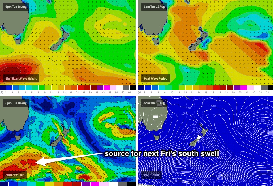
Looking beyond the Tues/Wed south swell, and we have some excellent long period southerly groundswell lining up for the longer term period. An intense polar low tracking along the ice shelf well below the continent on Sunday and Monday (see chart below) is expected to generate new energy that’ll probably reach the South Coast late Thursday, before filling into the Sydney region on Friday and holding through the first half of next weekend. At this stage we should be looking at excellent quality 3-5ft south swell at locations open to the south, with smaller surf elsewhere, and favourable conditions under a developing NW airstream. More on this in Monday’s update.
Comments
If it hit 3ft on Thursday afternoon it must have been late. I came out of the water at an absolute south swell magnet at 4.30 and it was a weak 2ft.
Was watching the Bondi surfcam late arvo and saw a few 3ft sets BB.
Probably just the lull between it hitting Bondi and it getting to the NB Ben though sometimes it seems to hit one area but not another. I have been surprised a few times by how much difference a few kilometres of the Sydney coast can make to the swell size. The same thing happens between the southern end of the northern beaches, say south of Long Reef and the northern end.
Yeah small down here too bb. Greet conditions tho just lacking the size.
My closest Buoy is still reading 2.3m at 6pm tonight. Might have have a chance tomorrow early
what the confidence on that 2-3ft SE swell late Monday? cheers
punching well above its weight this arvo!!!!
Yeah second that, a solid 3ft clean conditions this arvo at Illawarra SF beaches that like northly winds..
sounds like we surfed the same beach...
a beach that pumps in NE wind :)
Yeah solid weekend down South, 3-4ft+ beachies Saturday, more 2-3ft+ this morning before kicking back to a strong 3-4ft this afternoon with a new S'ly groundswell.
A little surprising to see Sunday's surf perform above expectations, especially considering the generally low buoy data (~1m Hsig for most of Sunday, which was down almost half a metre from Saturday, with comparable swell periods).
Certainly a few fun waves at Bondi this morning though.