Plenty more S/SE swell on the way

Sydney, Hunter and Illawarra Surf Forecast by Ben Matson (issued Wednesday 3rd June)
Best Days: Thurs: excellent, strong S/SE swell with great winds. Fri/Sat/Sun: really fun, pulsing S/SE swell with generally good winds. Wed: strong S'ly swell.
Recap: A large S’ly tending S/SE swell has produced great waves across many regions over the last two days, with early offshore winds creating clean conditions. Most open beaches have seen sets in excess of 6ft+ both days.
This week (June 4 - 5)
The Tasman Low responsible for our current swell event will deliver one final push of excellent surf, and it’s due to arrive over the coming hours.
On Monday evening a secondary low pressure centre developed just off New Zealand’s West Coast, merged with the broad parent low (responsible for the current swell), and strengthened S’ly winds to storm force strength across a considerable area. As this fetch was working on an already active sea state, and because the fetch tracked northwest then north as it ‘slingshot’ itself around the primary low, we’re going to see another strong pulse of secondary swell fill into the entire East Coast.
This event will building overnight tonight and trend downwards through Thursday but early morning should see easy 6ft+ sets at exposed south facing beaches, and possibly some bigger bombs at offshore bombies that focus long wavelength energy particularly well. Expect smaller waves at beaches not completely open to the south. Winds are expected to be light all day, probably some form of offshore but may trend variable at times.
For Friday, we’re looking at slowly easing size although early morning may still see occasional sets between 3ft and 5ft st south facing beaches (mainly in the Hunter). Light offshore winds all day will keep conditions nice and clean. Again, surf size will be much smaller at beaches with less southerly exposure, and we'll see a gradual drop in size and consistency during the day, but there should still be some good options throughout the day.
This weekend (June 6 - 7)
The weekend forecast has pulled back a bit since Monday’s notes. We’re still looking at renewal of swell from the S/SE courtesy of an active polar frontal passage from the ice shelf into southern New Zealand (from today thru’ Friday morning) however its alignment has shifted a little in the latest model runs and it’s now slightly more off-axis than previous data suggested.
As such, I’ve pulled back wave height estimations to around 3ft+ at south facing beaches on Saturday, becoming a little smaller Sunday (2-3ft). Wave heights will again be smaller at beaches not completely open to the south, however we may see a few bigger waves across the Hunter region both days.
Light variable winds are expected for most of Saturday, although we may see a possible light to moderate SE flow across the Hunter in response to a developing trough off the Far North Coast during the day. I’m doubtful that there’l be much strength in it, and we probably won’t see any influence south of about the Northern Beaches, but it’s a feature to watch in Friday’s forecast notes update.
As for Sunday, we should see great conditions just about everywhere as a series of strong fronts approaching the SE corner of the country steer winds back to the NW.
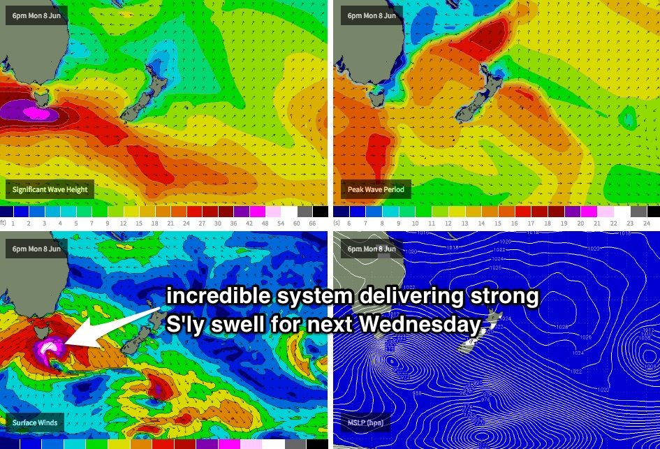
Next week (June 8 onwards)
A powerful series of fronts crossing the Tasmania region from Sunday onwards will deliver varying degrees of south swell to Southern NSW next week. Initially, the storm track will be too zonal (west-east) to allow for any notable size, so Monday and Tuesday will see mainly small residual energy out of the southern quadrant (the trough off the North Coast won't be favourable in position for us).
A small pulse is then due into the South Coast overnight Tuesday that should produce 2-3ft waves at south facing beaches on Wednesday, however a much stronger system (see below) trailing behind later Monday is then expected to provide a bigger secondary swell for Wednesday afternoon and maybe early Thursday that could reach 4-5ft at south facing beaches (and 6-8ft in the Hunter due to the acute southerly swell direction). More on this in Friday’s update.
Comments
Hi Ben,
Any chance of an eta for swell arrival. I'm planning on heading down tonight after work for a full moon surf. Reckon we might see it before 11PM tonight? I'll be watching the bouys until I leave work at around 8pm
Cheers
This could be the leading edge - Eden scored a similar increase a few hours earlier which fits in close to arrival expectations.
Hehe, just noticed myself. Gonna hit DY point again, it was awesome last night in the full moon. Not many times you get it to yourself when its barrelling all the way across!
Cheers Ben :-)
Looking solid again this morning.
Manly on the pump!
Shark Island looking tasty too.
Cloud cover came over as I was driving down last night & spoiled the fun :-(
The swell definitely picked up once the tide turned. There were a couple of really solid head high freight trains that started to push through after 9.30PM.
very solid morning Ben - I reckon it came in above expectation.. point breaks were about the only option in the Illawarra
More than 6-8ft oiley? Ben had 6ft+ and I think it's a pretty good call across the whole coast. Some bigger bombs at selected spots but mostly around that 6ft range.
it wasnt that big in illa at the surfable spots. 4-5. morning high tide skunked us
So Oiley reckons I was under and Geoffrey reckons I was over! Ha! Always hard to get the spread spot on, but I'm pretty stoked with the call.
Na mate u were spot on. The surfable spots I refered to are never the south swell magnets you refer to in these swell events mate. Top work once again mate. If anything it was a reflection of the dismal choices we have down here in largish South swells
Yeah no complaints here, agree with Geoffrey that east works best down here, but was more than enough juice for the points to be worth while
Bloody oath! I surfed about half a k up from your profile pic, was some widow makers coming through but some surprisingly makable ones. Fun as!
that impressive mate! there would have been some heavy sets coming in.. great stretch of beach
Reckon there's anything left in this swell for tonight, or it's all downhill. Bouys inc period have already dropped :-(
They have but the surf was still strong on dark, still 6ft sets in the mix.
Will check it out, but unless the northerly wind swings west, it will probably be wiped out.