Poor weekend; large and windy next week

Sydney, Hunter and Illawarra Surf Forecast by Ben Matson (issued Friday 17th April)
Best Days: Mon/Tues/Wed/Thurs: large to very large SE swells but windy as an ECL intensifies off the coast.
Recap: Plenty of good quality leftover surf on Thursday with generally clean conditions for most of the day, but there was very little on offer today with winds tending light to moderate onshore.
This weekend (Apr 18 - 20)
The weekend’s looking pretty average on the whole.
With no new swells in the water for Saturday, the only chance for a rideable wave will be sourced off a freshening northerly breeze during the day. If anything develops it’ll be small and low quality - exposed NE facing beaches may see poor quality 1-1.5ft waves through the afternoon but it’s not worth working around.
The dynamics of Sunday’s expected southerly change have been pushed around a little in the latest model runs. We’ll see an initial moderate SW change during the morning (NW winds across Sydney/Hunter beaches at dawn, but the sou'wester should be into the Illawarra fairly early).
However the core fetch expected to generate the first round of short range southerly swell isn't really expected to develop off the southern NSW coast until the middle of the day. As such the chances for a sizeable increase before dusk have diminished, but we should still see a late upwards trend, following a gusty southerly wind developing from about early-mid afternoon onwards.
What this means is that I’m less confident that protected southern corners will have anything worthwhile by the end of the day - it may not be quite big enough. There should be sizeable, bumpy waves at exposed south facing beaches (maybe some 4-5ft+ sets on dark), so hopefully you can find a compromise between size and quality at remaining open beaches, in the 2-3ft range.
If the model guidance changes notably before Sunday morning I’ll update the expected timing of the upwards trend in the comments below.
Next week (Apr 21 onwards)
As discussed all of last week, we’ve got a proper East Coast Low developing early next week, in the wake of Sunday’s southerly change.
Prior to its development (or during the early stages of cyclogenesis), gale force SE winds will envelop the southern NSW coast, probably from Monday onwards, and we’ll see a very large short range swell build across the region - likely into the 6-8ft range at exposed south facing beaches by the afternoon. Only protected southern corners will have anything worthwhile though.
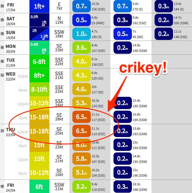
As the low deepens and moves closer to the Sydney/Illawarra coast (from a position further north-east), it’ll strengthen SE winds about its core, aimed across the broader southern NSW region. Right now it’s hard to be totally confident on the timing of this development but the most likely scenario is for a steady increase from 6-8ft early Tuesday up towards 10-12ft+ at exposed spots through Wednesday and possibly early Thursday (it’s worth nothing that the 18Z run of our surf model is calling 15-18ft surf Wednesday evening! I haven’t seen this before). Obviously, protected spots will be a lot smaller too.
However, this very large swell swell event will be accompanied with persistent SE gales, so conditions are not likely to be friendly for most surf spots. In fact this swell event will be well worth considering some of the more sheltered nooks and crannies, for a novelty wave.
Additionally - and without wanting to sit on the fence - whilst the models are in broad agreement that we’ll see an ECL develop off the coast, they differ in their outlook on the structure of the low. There is a suggestion that we could see a more straight S'ly or even SW flow at times across parts of the region, but as this scenario is still four or five days away we need more time to assess the model data. ECLs are notoriously complex and it’s common for local winds to defy model guidance.
In short, expect a lot of large surf, a lot of wind and a lot of rain right through next week. Conditions should then settle right across the board from Thursday onwards.
I’ll update my thoughts on any model deviations in the comments below over the weekend. Otherwise, see you Monday!
Comments
No comment
I could provide a list if possibilities but really, do you want to bother? The worst aspect of this event is that, if it plays out as predicted, the banks, which are just starting to recover, will probably be totally trashed. Lots of sand transported offshore, big inshore channels, fat slow outside peaks and close out shories for the entire winter!
Not so sure blindboy. I don't think the effect on the sand banks can be predicted on these big events, other than that it will take sand offshore. Everything else is chaotic and impossible to predict.
I'm happy to see so much sand off the beaches and back under the waves somewhere. The problem has largely been so much sand on the beaches, and having them carved up can't be bad.
Although I do agree with your comment about the banks just starting to recover, but my take on it is that they are recovering from a lack of big swells knocking them around. Too much sameness, we need some chaos to break things up.
Will be interesting to see what it does.
Sweet!! I'm heading out next week Wednesday (22/4) and Thursday (23/4) to carry out some filming (just for fun). Anyone else interested in joining give us a yell! Cash prizes available for 1 hour of your time. Cheers
definitely too much sand on the beach. the local beach is as wide as Ive ever seen it. The best surfs Ive had here are when the sand is all out to sea. Needs a big onshore mess to really move things around.
In the meantime, novelty spots mid week
Southerly change is in now: wonder how much size we'll see before the end of the day? Models seem pretty consistent with Friday's output so 4-5ft south facing beaches by dark still seems plausible. Just hope there's enough for a protected corner!
I think the pattern is fairly predictable as far as big swells go though some types of beaches are more resistant to erosion than others. Around Sydney most beaches progressively lose sand through autumn and early winter as there are more frequent large swells. The most common effect of this is to drag sand out where it forms deeper banks which often do not even link up to the remaining inshore banks. The beaches themselves retreat and become progessively steeper. The impact on the surf is almost always bad.
True sometimes an individual swell can create a new bank where there wasn't one before but for wild stormy conditions the overall impact is usually negative and if you have a number of very powerful storms close together the sand can take many years or even never, to return to normal. In my judgement several of the northern beaches have never fully recovered from Cyclone Colin and the other major storms of the late seventies. The banks no longer extend as far from the beaches and they are deeper.
Crowdy Head buoy looks nice this morning. I imagine that could make for some good double ups if you hunted around...? small otherwise.