Potential for a late pulse Sunday; big S'ly swell due Wednesday

Sydney, Hunter and Illawarra Surf Forecast by Ben Matson (issued Friday 2nd April)
Best Days: Sun: improving conditions with a fun short range swell (and a poss late E/NE pulse - keep an eye on the comments below for updates). Mon: small leftovers but clean with offshore winds. Wed/Thurs: large S'ly swell with gusty SW tending S'ly winds.
Recap: Thursday didn’t offer much more than a slow, weak 1-2ft of NE and E/NE swell. A late S’ly change pushed into the coast, building short range S/SE windswell across the region this morning (2-3ft south facing beaches, smaller elsewhere) however a new S’ly groundswell has just shown up across the South Coast as expected - if anything a few hours ahead of expectations - with good 3-5ft sets. This swell was generated by a low that developed east of Tasmania yesterday, and the swell should reach Sydney mid-late afternoon today (although, we need the onshores to ease back a little more for surface conditions to be worthwhile). Fortunately, this is looking quite possible with wind speeds already down 7kts at Little Bay since dawn, and 5kts at North Head.
This weekend (Apr 4 - 5)
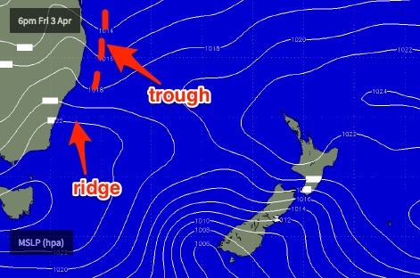 Let’s take a look at the synoptic chart first up.
We’ve got a ridge across the southern NSW coast, and a developing trough off the Far North Coast. This ridge will re-strengthen into Saturday as the trough takes shape - ahead of a southward track into Sunday - driving fresh and gusty SE winds across most regions during the day (a little lighter on the Far South Coast).
There won’t be any shortage of swell on Saturday. We’ll see today’s late new S’ly groundswell peak early and ease throughout the day (early sets between 3ft and maybe 5ft at south facing beaches), and the ridge should supply 3ft of peaky short range energy to most open beaches as well (smaller on the South Coast). But quality will be very ordinary.
On Sunday, a low is expected to form within the trough up north as it advances southwards. However even at just 36-48 hours out, there are some crucial differences in the atmospheric model forecasts that could be make-or-break for a great surf session, or an average one. This is mainly related to how the trough develops overnight Saturday.
Most models - including GFS, which powers our swell model and that of every other surf forecast website - push the trough too quickly down the coast to generate any meaningful swell. We’ll probably see a small pulse of E/NE swell into the afternoon (2ft) but it’s likely that lingering SE and S’ly swell from Saturday will end up being a more reliable source (say, 2-3ft at open south facing beaches in the morning).
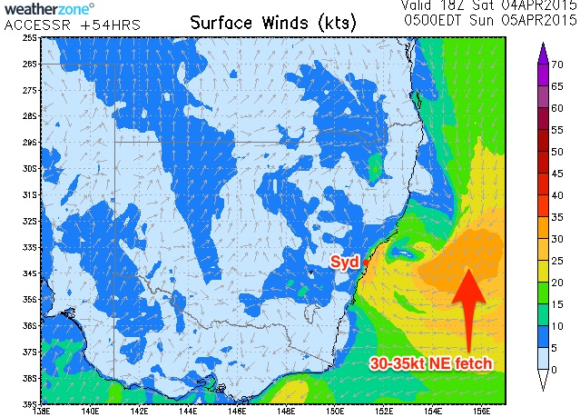 However, the BOM’s ACCESS-R model - a high resolution model that’s been performing reasonably well at times - has a much stronger and broader indeed of NE winds into the trough overnight on Saturday (see chart to the right) - which could theoretically generate 3ft to possibly 5ft of E/NE swell across the Sydney and Illawarra coasts from Sunday lunchtime onwards (smaller in the Hunter), with possibly some bigger waves on the South Coast.
Ordinarily, the most effective forecasting technique is to remove model outliers and take the line of best fit between all of the guidance. However ACCESS-R’s projections are just two days out - very close to genesis - and with complex troughs such as these often being one of the better sources of swell for southern NSW, I really don’t want to write it off completely. Not now, anyway.
Furthermore, local winds are expected to swing fresh S’ly then SW on Sunday (and possibly even W/SW in some areas), which is via broad agreement across all models - which means conditions should rapidly improve.
So, what’s the upshot of this?
I’ll fine tune these thoughts in the comments below on Saturday afternoon (and again early Sunday) but for now Sunday morning is likely to kick off with easing SE and S’ly swells, somewhere between 2ft and maybe 3ft at open south facing beaches (smaller elsewhere), but becoming smaller during the day. Winds will be swinging to the SW by this time but periods of S’ly winds can’t be ruled out early morning.
Any E/NE swell we see probably won’t kick in until lunchtime at the earliest, however if the model average pans out - i.e. a smaller event - then it’ll probably arrive mid-late afternoon. The South Coast will see a later arrival time than Sydney, probably some 3-5 hours.
Gut feel is that we’re probably looking at some late Sydney sets in the 3ft range from the E/NE (and maybe some bigger bombs on the South Coast on dark), however we’ll really just have to wait and see how things develop. Keep an eye on the comments below.
Next week (Apr 6 - 10)
Whatever E/NE swell we see on Sunday afternoon, it’ll be quickly the way out on Monday. Light W/NW winds will create clean conditions but you’ll have to aim for a dawn patrol to extract the maximum size (perhaps some stray 2-3ft sets at NE swell magnets in Sydney, smaller in the Hunter but a little bigger on the South Coast). Expect an easing trend all day. And, if Sunday doesn't end up coming in as expected, then wave heights will probably be smaller.
Strengthening NW winds on Tuesday will accompany the bottom of the swell cycle, however a deep low is expected to form off the Far South Coast overnight Tuesday and this should lead to a significant increase in southerly swell for Wednesday - albeit with strong SW tending S’ly winds (gale force on the South Coast).
South facing beaches should push upwards of 6ft to maybe 8ft at times, although conditions probably won’t be conducive for surfing at these spots due to the strong winds. And, becasue of the acute southerly swell direction, wave heights will be small at protected spots. Let's wait and see how things evolve over the coming days but there should be some reasonable options if you're prepared to compromise between size and quality.
Wednesday's swell will continue through Thursday albeit in a slowly weakening phase (both wave heights and wind speeds) with smaller surf and light winds expected by Friday.
Long term (Apr 11 onwards)
Nothing significant on the cards beyond that. A couple of deep Southern Ocean lows tracking through our distant swell window mid-late next week should supply small long range S’ly swell through next week and into the first half of next week, but at this stage nothing spectacular is on the cards. More on this in Monday’s update.
Comments
Ben with the updated models for tommorow what chance do you see of the ne swell that you discussed materialising for tommorow
Still 50/50 at this stage.. We really need to see a satellite pass to confirm ocean winds, which won't be available for another 6 hours. I'll take a closer look in the morning.
Loking good this morning with a peaky combo of swells in the 3ft range and light offshore winds. Still looking possible for a further pulse in size from the E/NE during the day - overnight ASCAT reading showed some promise with a good fetch in our swell window - but I am concerned that it'll track too quickly to the south. Nevertheless all beaches across Sydney should be pumping this morning.
Rather tasty options a short time ago when I filed the Northern Beaches surf report. Easy 3-4ft sets on offer with super clean conditions under a light offshore breeze.
MHL buoy has dropped since this morning but the surf seems to have pulsed up north, so I wouldn't rule out a late surge in size across southern NSW (that should persist into Monday AM too). South Coast should see some unreal waves tomorrow morning as this E/NE swell spikes.
Smaller this morning but super clean on top with the odd 2ft+ set about the traps. But it's definitely easing.
Nice random screenshot from our Manly surfcam.
pus.
Come on Huey! YOU CAN DO IT!
Hows next tues weds or watever looking ?
Assuming Ben hasn't changed his schedule the new forecaster notes shouldn't be long in appearing.
Sydney notes went up a short time ago. Here ya go (no rest on public holidays, eh?).