Average weekend ahead, bigger east swell next week

Sydney, Hunter and Illawarra Surf Forecast by Ben Matson (issued Friday 13th March)
Best Days: Sat AM: maybe some peaky leftover short range SE swell, as local winds ease. Nothing special though. Mon/Tues/Wed: building E'ly swell
Recap: Small waves Thursday with early light SW winds ahead of a freshening southerly change. Building S’ly windswell today with gusty S/SE moderating later this afternoon. Biggest at south facing beaches (3ft+) but very small elsewhere due to the swell direction.
This weekend (Mar 14 - 15)
Saturday should have some workable waves.
Today’s short range S’ly swell will swing more to the SE thanks to the responsible ridge in the southern Tasman anchoring in place today, but it’ll weaken overnight so surf size will drop through the afternoon.
Early morning should see 2-3ft+ sets at south facing beaches (smaller elsewhere but a few possible bigger bombs in the Hunter) however locations north of Wollongong - i.e. Sydney thru’ the Hunter - are at risk of a lingering onshore wind early morning. There’s a chance for an early light outflow in a few select metropolitan areas (i.e. Northern Beaches) but I’m a little cautious on whether this will eventuate.
Nevertheless, a weakening pressure gradient during the morning will create light variable winds through the middle of the day with light sea breezes into the afternoon. Winds south of Wollongong should be light and variable all day with NE sea breezes. Expect a slow easing trend in the size department through mid-late afternoon.
On Sunday we’ve seen a small change in the model data since Wednesday regarding local winds - it’s now likely that a southerly change will push through during the morning. With only small swells on offer (residual, fading short range SE energy and a small trade swell, both at 1-2ft) it’s hard to get excited about anything worthwhile.
We should see a small southerly windswell build through the afternoon but quality will be low at those beaches picking up the size. Eventual size will depend on wind strength (of which the models are in disagreement) but bumpy 2-3ft+ sets are possible at swell magnets by the end of the day.
Next week (Mar 17 onwards)
Sunday’s southerly change will linger into Monday morning but weaken throughout the day. As such surface conditions will be a little ragged to begin with but should improve into the afternoon.
There doesn’t seem to be much of a fetch trailing the change so we’ll probably see just a minor south swell at the same time, perhaps some 2-3ft sets at south facing beaches (bigger in the Hunter, smaller elsewhere).
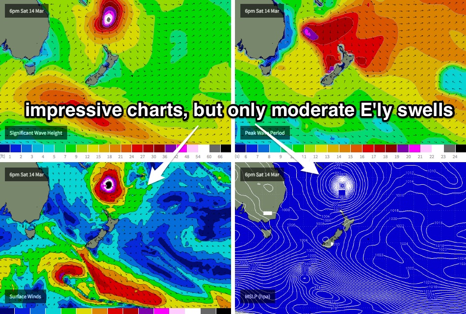
On the broader synoptic discussion, I haven’t changed my thoughts from Wednesday notes: that is, despite the models predicting half a metre of NE groundswell at 19 seconds (from TC Pam) for Monday, I don’t think it’ll eventuate and/or translate to much surf at the coast. The associated fetch supposedly generating this swell is still inside the swell shadow of New Caledonia, and once it clears to the south (on Saturday) it’ll track too quickly to the south-east in order to generate anything meaningful.
Nevertheless, in the name of good science, I’ll be keeping a close eye on the buoy data (and the beach).
As discussed at length for much of the last week, I still am not expecting fireworks from the latter stages of TC Pam either, as it tracks from the Tropical South Pacific over to waters east of New Zealand.
The supporting ridge to the south of TC Pam (through Saturday and Sunday) will generate a decent swell out of the east however pinpointing each phase (arrival, upwards trend, peak, downwards trend) is a little difficult due to the sheer complexity of the region’s synoptics.
Right now I think we’ll see a small undercurrent of trade swell on Monday (occ 2ft+ set at open beaches), building during Tuesday with 3-4ft sets by the afternoon (smaller earlier), holding into Wednesday morning of a similar size before easing into the afternoon. Had TC Pam been forecast to track more slowly SE, we could have potentially doubled if not tripled these estimates but the SE track across the Great Circle paths diminishes our surf potential quite a bit.
Local conditions look a little dicey on Tuesday and Wednesday as winds freshen from the north-east, in fact we may see a small local mid-week windswell as a result. Early mornings should have periods of light variable winds though (mainly Tuesday morning, less likely Wednesday). I’ll hone in on the specifics on this in Monday’s notes.
Otherwise, following this easterly swell event, the next major pattern is expected to kick in late Friday through Saturday as the Long Wave Trough moves across the region. This should bring a solid south swell sometime around next weekend, but I’ll update this in more detail over the coming week.
Have a great weekend, see you Monday!