Strong southerly swell to continue

Sydney, Hunter and Illawarra Surf Forecast by Ben Matson (issued Friday 19th September)
Best Days: Sat/Sun: plenty of south swell but tricky winds (likely to be brief windows of opportunity early mornings). Mon: good S/SE swell with early offshores.
Recap: Been a sluggish couple of days but there has certainly been plenty of south swell in the water. Inconsistent 3ft sets at south facing beaches on Thursday morning built a little into the afternoon, albeit with a southerly wind, holding into this morning with much cleaner conditions (Newcastle reported 4-6ft surf this AM). We’ve seen a stronger pulse of energy this afternoon - against forecast expectations of a slight easing trend - with some of Sydney’s south facing beaches pulling in 4-5ft sets, however the early offshore is now light onshore so conditions have deteriorated slightly.
This weekend (Sep 20-21)
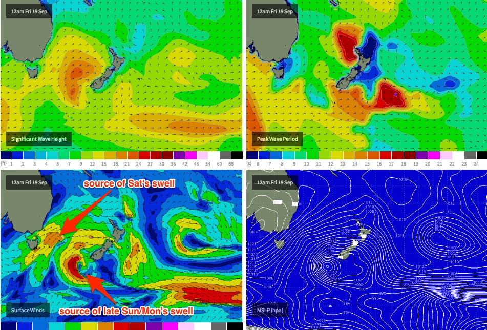
We’ve got plenty of south swell expected this weekend. Two cold fronts associated with the same parent system that generated the current swell are racing through the lower Tasman Sea as we speak, and they’ll generate a strong burst of energy for most of Saturday and Sunday morning.
The main factor to work around this weekend are the local winds. A fresh S/SW tending S’ly change is expected into Sydney early/mid morning on Saturday, and this will create very bumpy conditions at those exposed beaches picking up the most size. Winds will however be W/SW prior to its arrival.
At this stage the change is expected to reach the South Coast before dawn, arriving into the Cronulla region within an hour or two of first light, before impacting the Northern Beaches by mid-morning and then the Hunter mid-late morning.
So, the early bird will get the worm - but if you had to hedge your bets, I’d aim for the most northern stretch of coast at your disposal. I fear that Cronulla surfers may not get much of a window of opportunity at all (conversely, these patterns sometimes stall across the central Sydney region, allowing favourable winds to linger a little longer on the Northern Beaches).
South facing beaches should hover between 3-5ft for much of Saturday and most of Sunday (mainly in the morning). Conditions on Sunday looks like they’ll be a more moderate version of Saturday with easing S’ly winds, however some locations - again, possibly only the Northern Beaches - should see a few hours of early W/SW winds before the synoptic breeze takes over.
Also, we’re looking at a strong S/SE swell arriving overnight on Sunday (from a secondary fetch closer to the SW tip of New Zealand's South Island, see chart below), however current model guidance suggests the leading edge may not arrive into Sydney until the early evening.
Gut feeling is that this swell will slightly out-run the model data (i.e. arrive ahead of what’s forecast), so I’m hoping for the last hour or two of the day to see a strong pulse back up into the 3-5ft range across the Cronulla stretch, the Eastern Beaches and the Northern Beaches (possibly the Hunter if we’re lucky, but it’s less likely here). The South Coast will also see this swell a few hours earlier so keep an eye out for it - with some luck the southerly will have eased further, allowing for conditions to improve a notch or two.
Next week (Sep 22-26)
Sunday night’s S/SE swell looks really good on paper at the moment. It’s a shame its expected to arrive in the early evening, as the bulk energy will probably peak under the cover of darkness.
However we should still see some very nice waves on offer early morning. Set waves should be somewhere between 3ft and occasionally 5ft at south facing beaches, and the extra SE in the swell direction should allow for a slightly broader spread of swell across various beaches compared to our current (and expected weekend) southerly energy. Even better, winds should be light offshore on Monday morning, which will create smooth conditions.
This swell will slowly ease throughout Monday and continue a downwards trend from Tuesday onwards.
There are no significant swells on the card for the rest of the week at this stage - model guidance has a large blocking high in the Tasman all week, steering a series of intense polar lows well south of our far southern swell window. We’ll probably see small long period lines from this source all week (exclusive to south facing beaches) but no major size is expected.
Long term (Sep 27 onwards)
Nothing significant on the charts beyond the end of next week either. There’s a suggestion for a frontal passage through the lower Tasman Sea next weekend (which would lead to a renewal of mid range south swell) but it’s too early to call. I’ll have an update for you on Monday.
Comments
Still pulsing nicely this arvo.
ben what size do you think the merewether region will be next week? ta
Photo 3 Newcastle report... step off??? Looks like he's going pretty fast for a barely crumbling wave