Large E/SE swell due on Thursday

Sydney, Hunter and Illawarra Surf Forecast by Ben Matson (issued Monday 7th June)
Best Days: Tues/Wed: small but fun SE swells with good winds. Thurs: solid E/SE groundswell with gusty offshore winds. Fri: combo of easing E/SE swell and building S'ly swell, with fresh offshore winds.
Recap: Fun small S/SE swell over the weekend, around 2ft+ in Sydney and closer to 3ft in the Hunter with offshore winds. A little smaller Sunday (mainly 2ft Sydney, bigger in the Hunter) and similarly clean. A new S/SE groundswell has filled in this morning, building south-facing beaches from 2ft early up to 4ft this afternoon (with bigger surf in the 4-6ft range reported in the Far South). Winds are still offshore so conditions are nice and clean.
This week (July 8-11)
We’ve got a cracking swell forecast ahead however we’ll kick off the next few days with a small supply of intermittent, background SE swells. These pulses will originate from two modest fetches related to the primary system that generated today’s swell, however they’re both a little weaker and consequently will deliver small size across most beaches.
Expect clean but slightly inconsistent 2-3ft waves across south facing beaches of the Sydney, Hunter and Illawarra coasts on Tuesday, trending a little smaller during the day and into Wednesday, however conditions will be smooth with freshening westerly tending north-westerly winds. Expect smaller surf elsewhere.
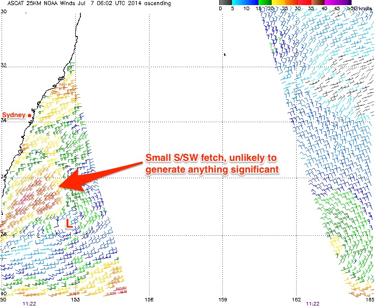
It’s also worth pointing out that the broad low pressure occupying the lower Tasman Sea right now also has a small centre positioned just off the South Coast. ASCAT data picked up a small S/SW fetch offshore from about Ulladulla overnight and again this morning however it’s very short and narrow, and will probably be steered more SW in direction over the coming 12 hours (see image below). As such I think the chances for a notable local - ie short range - south swell early tomorrow isn’t very high.
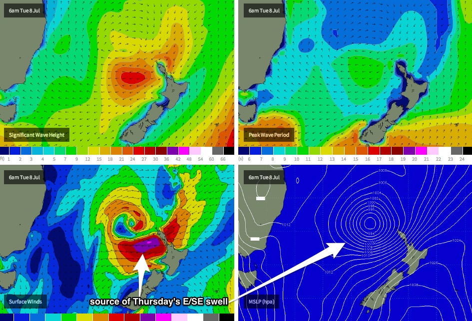
Where we need to focus our attention over the coming 24-48 hours is the waters north-west of New Zealand. As I’ve been discussing since last Wednesday, the broad trough occupying the central Tasman Sea stretches all the way up to New Caledonian longitudes, and a new low pressure system is expected to form mid-way between New Caledonia and New Zealand tonight, before tracking south to a position off the west coast of the North Island during Tuesday.
As this happens, the low will push up against a strong, stationary high pressure system to the south-east of New Zealand, resulting in a strengthening E/NE thru’ E’ly airstream inside our swell window that’ll reach gale to storm force through Tuesday and early Wednesday, generating a heavy swell for the southern NSW coast on Thursday.
If there were a negative about this system, it’s that the resulting fetch will be aimed more towards the South Coast than anywhere else - so wave heights will be smaller in the Sydney, Hunter and Illawarra regions than the South Coast.
However, as suggested on Friday, the models have been a little cautious with this system to date and it’s really only been the last 24 hours where we’re now seeing strong consolidation across them all - so confidence is much higher for Thursday’s swell event. This also means we can more confidently increase projected wave heights.
The leading edge of the E/SE swell is due overnight Wednesday and by Thursday morning there should be solid waves in the water, somewhere around 5-6ft across most open beaches ahead of a slow easing trend into the afternoon. Locations on the South Coast will see even more size, upwards of 6-8ft at those reefs that enjoy this swell swell direction (more E’ly here) however the swell may not be at full capacity at dawn.
You will however have to factor in fresh to strong offshore winds from the W/NW as another strong frontal progression tracks across Victorian longitudes. Keep this in mind if you’re planning on surfing a deepwater reef as there will be a lot of wind up the face.
This swell will slowly decrease from late Thursday (in Sydney) and early Friday (in the south) onwards, however there should still be plenty of size around to finish off the working week, along with a gusty but moderating westerly airstream.
In fact we’ll probably see a building southerly swell during the day from our favourite flukey south swell window - W/SW gales exiting the waters of eastern Bass Strait. This won’t deliver a great deal of size to locations south of about Jervis Bay or Wollongong (due to the axis of refraction, which I've discussed previously), however south facing beaches in Sydney and the Hunter should pick up some 3ft+ sets into the afternoon. Couple this in with an easing E’ly swell and a moderate to fresh offshore breeze, and Friday afternoon is on target for some very fun peaky beachbreaks right across the coast.
This weekend (July 12-13)
Thursday’s east swell will be quite a bit smaller by Saturday with just a couple of feet of leftover energy in the water. Same too with Friday’s afternoon south swell - it’ll be on the way out by Saturday, so expect small peaky waves at exposed beaches with moderate offshore winds from the NW.
A strong southerly change is modelled to track through the lower Tasman Sea Saturday evening and this is projected to bring a solid increase in new southerly swell for Sunday, however winds look like they’ll be fresh and gusty from the S/SW at times, (following a period of early W/SW winds) and this will reduce the potential at exposed south facing beaches. However size could reach 4-5ft+ at these locations, and that should mean there'll be enough size for some fun small clean waves inside sheltered locations. If nothing else, it’s great to have an active forecast with lots of potential on the cards. I'll refine the details on Wednesday.
Next week (July 14 onwards)
No real changes to the storm track pattern that’s dominated our swell window for much of the last month or so. We’re looking at plenty of south swell early next week, and long range modelling suggests this theme will continue through the middle to latter part of next week, albeit from more distant sources in the South Ocean. I’ll have more idea on the specifics in Wednesday’s update.
Comments
FROTHING!
Still not big enough for red bull comp ? wrong direction, Tim whats prime cond for ours ? fuck they gotta be running out of time.
Current BOM forecast for Sydney Coastal Waters Thursday: "East to southeasterly 1.5 metres, decreasing to around 1 metre during the evening."
Hmmm. Watch this space.
50kts already confirmed that the back of the (still developing) fetch. Kinda wanted to put a '+' on yesterday's figures but piked out. Models have subsequently upgraded a little overnight.. and now fetch confirmation via scatterometer.. it's game on! Just gotta hope those offshores aren't too strong.
Surprise surprise - the BOM have upgraded the swell forecast for Thursday with their 4pm update:
"Easterly 2 to 2.5 metres, decreasing to 1.5 metres later in the evening. Caution:
Large and powerful surf conditions are expected to be hazardous for coastal activities such as crossing bars by boat and rock fishing."
Ben, why isn't the swellnet model data picking up the swell? The model is still calling it 4ft as at noon today
Actually, our wave model failed on the 18Z run (this is a rare occurence) and is currently displaying 12Z data. However, the forecast had 4-6ft yesterday - I'm not sure for the reasons of the minor downgrade but it still has a peak tomorrow lunchtime at 3-5ft (no changes from my end though, I think it'll be 5-6ft from early/mid-morning thru' lunch).
We have arranged our verbose surf forecast descriptions (ie 3-4ft, 4ft, 3-5ft, 4-5ft, 4-6ft, 5-6ft, 6ft etc) in numerical order, so in this case the actual change between Monday's and Tuesday's model runs might have been only small (say, half a metre or less).
However I wouldn't be surprised if it nudges it up again on this afternoon's 00Z run (due in around 4:30pm).
The verbosity is well appreciated