Lots of small southerly swells inbound

Sydney, Hunter and Illawarra Surf Forecast by Ben Matson (issued Wednesday 18th June)
Best Days: Thurs: easing S'ly swell early, building later with a small new S'ly pulse. Light winds all 'round Fri/Sat: fun S'ly swell with good winds. Sun/Mon: couple of pulses of small, inconsistent S/SE swell, generally good conditions.
Recap: No shortage of south swell over the last few days. Wave heights eased throughout Tuesday but lifted again overnight and into this morning, however the mornings had the best waves under a westerly regime with afternoon southerlies developing both days.
This week (June 17-20)
Wave heights are currently easing across the Sydney region and will continue to drop into Thursday morning. However, a series of strong fronts have been powering through the lower Tasman Sea over the last day or two and although not very well aligned for the East Coast, are generating a series of southerly groundswells that’ll impact the region for the short term.
The first new pulse is expected into the South Coast on Thursday morning and should reach the Sydney, Hunter and Illawarra region into the afternoon, with a slight lift offering inconsistent 2-3ft sets at south facing beaches by close of business (and marginally bigger waves in the Hunter). Light variable winds are expected all day but they’ll swing northerly in the afternoon. Just keep in mind that this swell is expected to be rather inconsistent.
A second, slightly stronger pulse is expected to push through on Friday and although only a little more size is expected (whack a plus on Thursday’s size in Sydney, and maybe another foot or two in the Hunter), conditions should be excellent with freshening NW winds. A great day for exposed south facing beaches, and with some luck the consistency will increase from Thursday.
This weekend (June 21-22)
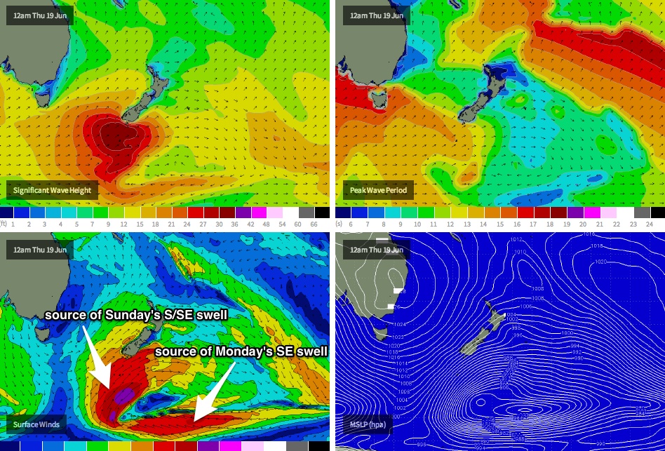
The weekend’s looking pretty good all round. We’re expecting to see fun, residual south swell across the region on Saturday (2ft+ most south facing beaches, a foot or two bigger in the Hunter), along with a new pulse of S/SE groundswell on Sunday, originating from a polar low expected to form well south of New Zealand tonight and merge with the tail end of the fronts generating the S’ly swells expected through Thursday and Friday.
In fact, this polar low is expected to undergo several areas of intensification over the coming days - one immediately south of New Zealand and a second to the south-east (see chart below), which will maintain small levels of SE groundswell into the start of next week. No major size is likely from this source (say, very inconsistent 2-3ft sets at south facing beaches, bigger in the Hunter) but in the absence of any other swells there should be fun waves at most exposed spots.
Wind wise, we’re looking at a weak trough developing across the western Tasman Sea over the weekend. This is likely to swing moderate W’ly winds on Saturday around to the SW on Sunday, but without any major strength. So overall pretty good on the surface, apart from the Hunter which may fall foul of these SW winds on Sunday if they freshen above 10-15kts. I’ll fine tune these estimates on Friday.
Next week (June 23 onwards)
As discussed above, we’ve got a second small inconsistent SE groundswell on target for Monday that should keep exposed beaches flush with small rideable waves (somewhere in the 2-3ft range, with long breaks between sets).
Looking beyond this, and a very vigorous frontal passage is expected to cross the SE corner of the country through Tuesday that will strengthen westerly winds about the region. At this stage, the models are favouring a northern storm track - mainly over the continent - but it’s likely that the swell window will finally become active through Tuesday afternoon, resulting in an upwards trend in south swell that’s likely to peak Wednesday afternoon or perhaps even Thursday. It’s too early to pin down specifics but at this stage it’s highly likely that our attention will be focussed on southerly swell for much of next week. And I wouldn't rule out the models shifting the storm track further south, which could significantly increase the current model projects of about 4ft at south facing beaches early Thursday morning (and could also bring forward the timing of the peak too).
Just one other region to put on the radar for next week - the tropical South Pacific, south of Fiji. A stationary high east of New Zealand and a broadening area of low pressure across Fijian longitudes are expected to moderately strengthen the trades in this vicinity, and while not currently on target for any major developments, is certainly worth keeping an eye on in the event that the models upgrade things. I’ll have a closer look on Friday.