Average couple of days, better later week

Southern Tasmanian Forecast by Craig Brokensha (issued Monday July 28th)
Best Days: Friday, Saturday, Sunday
Features of the Forecast (tl;dr)
- Weak S swell for tomorrow AM, easing into Wed
- Secondary S swell for Wed PM
- Strong but easing SW winds tomorrow, possibly tending W/SW for a period
- W/NW-NW tending S/SE winds Wed
- Late increase in moderate sized SW groundswell Thu with SW winds
- Larger mix of swells Fri with NW tending N/NE winds
- Easing surf Sat with N/NW tending N/NE winds
Recap
Saturday was poor with strong winds out of the north-eastern quadrant, better yesterday but only small to tiny and to 1-1.5ft. Today we’ve got a lift in swell to 1-2ft with nice, clean conditions.
This week and weekend (Jul 29 - Aug 3)
A broad, slow moving mid-latitude low is moving in from the west and this is expected to pass across us this afternoon/evening, bringing with it a weak fetch of S/SW winds in our southern swell window this evening.
A low period, weak S/SW swell is then expected tomorrow with sets to 2-3ft across Clifton with strong but easing SW winds, possibly tending W/SW for a period before reverting back to the SW.
Wednesday morning looks cleaner with a W/NW-NW offshore but it’ll then revert to the S/SE into the afternoon as a trough pushes across us.

Swell wise, the windswell will be back to 1ft to possibly 2ft, while the trough itself looks to bring some new S’ly swell to 2ft with the onshore wind, easing Thursday but with persistent SW winds.
Friday and Saturday look much better for a surf as a couple of good though inconsistent SW groundswells fill in.
As touched on last week, a stream of east-southeast tracking frontal activity taking place to the south-west of Western Australia from yesterday through the coming days should generate some good pulses of swell.
The first and least consistent increase through later Thursday and Friday morning has already been generated by a polar low at the head of the frontal activity, with a fetch storm-force to hurricane-force W-W/NW winds producing some inconsistent but strong 3ft sets.
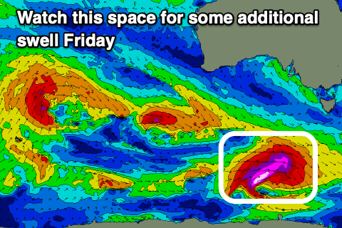
The secondary, more patchy and weaker activity looks to generate fetches of severe-gale W/NW winds while tracking towards the polar shelf, possibly strengthening south-southwest of us in its final stages Thursday.
If this does occur, a larger increase in groundswell is on the cards for Friday during the day, but at this stage let’s peg it at 3ft+ and check back Wednesday for an update.
Local winds look favourable and NW tending N/NE Friday with N/NW tending N/NE winds through Saturday.
Longer term the outlook is a bit slow ahead of some new swell mid-late next week.