Plenty of surf to come

Southern Tasmanian Surf Forecast by Craig Brokensha (issued Wednesday February 7th)
Best Days: Tomorrow morning, Friday morning, Saturday morning, Sunday morning, Tuesday morning
Features of the Forecast (tl;dr)
- Inconsistent, moderate sized S/SE groundswell building tomorrow, peaking overnight, easing Fri
- Variable winds ahead of a gusty S/SE breeze tomorrow, N/NW tending strong SW early PM Fri
- Large S/SW groundswell for Sat AM, easing steadily through the day with S/SW tending S/SE winds
- Smaller Sun with N/NW winds ahead of a S/SE change
- Small-mod sized mid-period SW swell for Mon PM with W/NW tending SE winds, easing Tue with W/NW tending S/SW winds
Recap
Fun, easing surf yesterday, tiny today.
This week and weekend (Feb 8 - 11)
After a couple of smaller days we've got some good swell due over the coming period.
Firstly, an inconsistent S/SE groundswell is due tomorrow, with it building through the day and peaking into the evening before easing Friday.
The source was a strong polar low and a fetch of gale to severe-gale S/SE winds wrapping around its southern flank.
Clifton should reach 3ft+ tomorrow afternoon and evening before easing from a similar size on Friday morning (expect larger surf across exposed breaks down the Arm).
Winds tomorrow morning should be variable ahead of a gusty S/SE change as the swell builds into the afternoon, cleaner Friday with a NW offshore ahead of a strong, early afternoon SW change.
Now, as touched on in Monday's update, this change is linked to a strong polar low firing up to our south-west tomorrow.
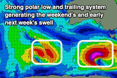
The catalyst for the low will be the remnants of another tropical low in the Indian Ocean, drifting south-east into the westerly storm track, deepening significantly south-west of us.
A fetch of severe-gale to storm-force W/SW-SW winds will be generated through our south-western swell window tomorrow, pushing further east and through our southern swell window Friday.
A large, powerful SW tending S/SW groundswell is expected, with it arriving overnight Friday and peaking Saturday morning to an easy 6ft across Clifton, easing steadily through the day.
Unfortunately gusty SW-S/SW winds are due in the wake of Friday's change with Sunday coming in clean under a N/NW offshore with easing 3ft+ sets.
As also touched on in Monday's notes, some reinforcing levels of SW swell are due into next week, the furst being generated by strong W/NW winds along the polar shelf. This should provide a kick back to 2ft+ across Clifton Monday afternoon, easing Tuesday from 2ft or so. Winds will be onshore Monday afternoon and conditions best Tuesday morning.
Longer term another swell is on the cards for later week but more on this Friday.