More strong surf for the coming period with bouts of onshore wind

Southern Tasmanian Forecast by Craig Brokensha (issued Wednesday December 27th)
Best Days: Today, Friday, Sunday morning, Monday morning, Tuesday morning
Features of the Forecast (tl;dr)
- Easing S/SW swell tomorrow with fresh S/SW winds, tending strong SW
- Smaller Fri with W/NW winds
- Possible late increase in W/SW swell Fri
- Moderate + sized SW swell building Sat with strong SW winds, easing Sun with NW tending strong S/SE winds
- Smaller Mon AM, with a moderate sized S/SW groundswell for the PM, easing Tue
- Light offshore tending strong S'ly winds Mon, variable S Tue AM
Recap
Our fun pulse of mid-period swell for yesterday offered clean 2ft sets across Clifton, while the stronger pulse of S/SW energy today has pushed to 3-4ft with light, variable morning winds.
This week and weekend (Dec 28 - 31)
Today’s swell is due to peak this afternoon, then easing back through tomorrow and further Friday.
Our onshore S/SW change is on track though, creating poor conditions tomorrow, with strengthening SW winds into the afternoon.
Friday now looks clean all day with persistent W/NW winds and a fun 2ft of swell. We might see some mid-period W/SW swell energy arriving through the afternoon, generated by a strong polar frontal progression approaching the state.
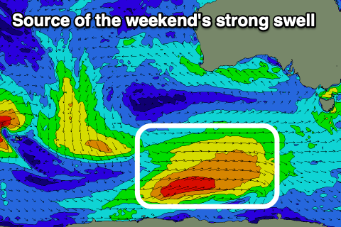
This progression will form to the south-southwest of Western Australia this evening, generating a fetch of strong to near gale force winds W/SW winds while tracking towards us over the coming days.
A moderate + sized SW swell is due on the weekend, building Saturday to a decent size followed by the peak in swell period energy Sunday morning.
Clifton should build to 4-5ft into the afternoon Saturday, easing from 4ft+ on Sunday morning under strong SW winds on the former, NW on the Sunday ahead of fresh afternoon sea breezes.
The swell will ease back into Monday, but another pulse of strong S/SW swell is due into the afternoon, generated by a strong, trailing polar front on the backside of the original system.
Core wind speeds look to reach gale-force and this should generate another good kick later Monday to 3-4ft, easing Tuesday from a similar size.
Conditions look clean Monday morning ahead of strong S’ly sea breezes, with a variable S’ly wind Tuesday. We’ll confirm this on Friday though.