S/SE swell to persist

Southern Tasmanian Surf Forecast by Craig Brokensha (issued Wednesday July 5th)
Best Days: Thursday, Friday, Saturday
Features of the Forecast (tl;dr)
- Slight drop in inconsistent S/SE swell tomorrow, with a final pulse Fri, easing Sat
- N tending variable winds tomorrow, fresher Fri AM
- Strong N/NE tending N/NW winds Sun
- Small W/SW swell Sun with strong W-W/SW winds
Recap
A bit less size yesterday back to 1-2ft, while today some inconsistent S/SE groundswell is offering infrequent 2ft+ sets with good winds all day.

Inconsistent but decent sized S/SE swell
This week and next (Jul 6 - 14)
Pulsey levels of inconsistent S/SE swell will pad out the rest of the week, generated by fetches of southerly winds at the base of a broad, slow moving Southern Ocean gyre that sat east of New Zealand.
We should see Clifton continuing around 2ft tomorrow (inconsistent and with bigger sets down the Arm), ahead of a final pulse Friday to 2ft to occasionally 3ft across Clifton.
Winds look to remain favourable with morning N'ly offshores, variable into the afternoons.
An easing trend is expected from Saturday with fading 2ft sets and strong N/NE tending N/NW winds.
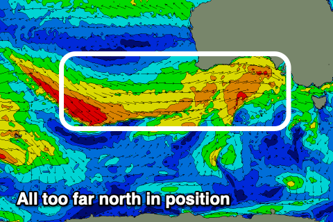
Looking longer term, and the westerly storm track looks to have been shunted a little further north than the forecasts were showing on Monday and with this, we're not expected to see much W'ly swell at all through the weekend.
What we will see is some localised mid-period swell from the tail of a low moving under us Saturday evening. This should kick up 2ft or so of swell Sunday but with strong W-W/SW winds.
Longer term we've got increasing activity but again all too far north in general. More on this Friday.