Lots of swell to work with

Southern Tasmania Surf Forecast by Craig Brokensha (issued Friday 16th April)
Best Days: Saturday, Sunday, Monday, Tuesday morning, late next week
Features of the Forecast (tl;dr)
- Easing surf into tomorrow AM with a new swell for the PM, peaking Sun AM, with a secondary pulse Mon with favourable winds for the most part (least likely Sat)
- Large W/SW groundswell late next week
Recap
An initial increase in swell yesterday to 2ft, while today we've got our larger mix of SW and S/SW swells offering 4-6ft surf across Clifton.
This weekend and next week (Apr 17 - 23)
The strong, drawn out polar front linked to today's large surf has left our swell window and we'll see the size easing quite a bit overnight, dropping from 2-3ft tomorrow morning.
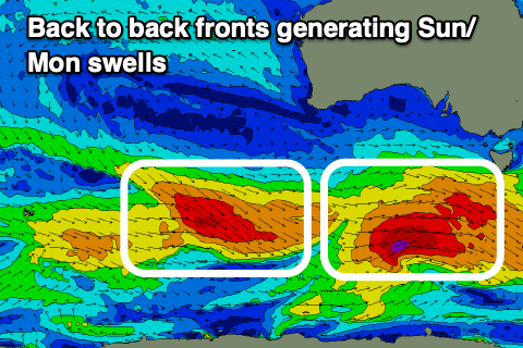 The easing trend will only be temporary though with back to back strengthening fronts due to bring some good, reinforcing W/SW-SW groundswell through the afternoon and Monday.
The first of these fronts now looks to be the strongest, but with the second acting on the active sea state from the first, both pulses should come in around a similar size.
Currently a great fetch of W/NW-W/SW gales are being generated through our south-western swell window, almost reaching severe-gale strength. This will produce an initial pulse of SW swell late tomorrow but more so Sunday morning to 3-4ft across Clifton, easing a touch through the day with the secondary front producing a reinforcing swell for Monday to 3ft+, easing through the day and back from 2ft Tuesday.
Conditions will be favourable with a N/NW tending W/SW breeze tomorrow, N/NW tending W on Sunday and N/NE tending NW winds on Monday.
The swell looks to bottom out into the middle of the week, but looking at later next week, we've got another significant swell on the cards.
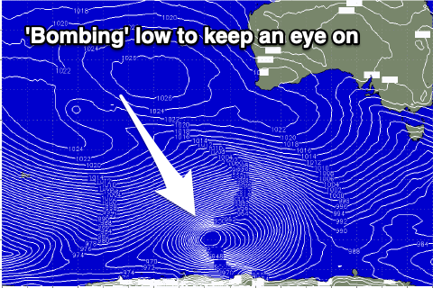 We're looking at another 'bombing' low, with the catalyst being a strong low that's due to form off the South African coast today (south of Madagascar), forecast to track east on the weekend before being reabsorbed into the westerly storm track.
We'll see the low drop significantly in central pressure south-southwest of Western Australia, generating a fetch of severe-gale to storm-force W/SW winds, weakening while projecting up towards us through next week.
The swell looks more west than the last few large swells, but sizey and peaking Thursday evening/Friday. More on this Monday though. Have a great weekend!
Comments
Better points today than last Sunday. Direction had a bearing?
Last weekend's swell was more west.
Thanks Craig.
Maybe you guys can drop the word bombing low, and it might keep the crowds down it's getting a bit crazy on the points.