Easing surf as onshore winds kick in

Southern Tasmania Surf Forecast by Craig Brokensha (issued Friday 22nd May)
Best Days: Tomorrow morning
Recap
Building surf through yesterday but peaking this morning with large and clean 4-6ft waves, pumping for experienced surfers.
This weekend and next week (May 23 - 29)
This morning's peak in SW tending S/SW groundswell will be followed by a steady downwards trend tomorrow and further into Saturday.
There should still be 3ft+ sets on offer tomorrow morning but go early as a morning W/NW breeze will shift S/SW later morning.
 We've then got poor and gusty S winds on Sunday with smaller fading 2ft sets.
Later in the day Sunday a new W/SW groundswell should be seen, with it hopefully keeping 2ft sets into Monday, though inconsistent. The source was a strong polar low south-west of WA mid-week, generating a fetch of severe-gale to storm-force W/NW winds in our far swell window.
Conditions look to remain average on Monday though with a lingering onshore S'ly breeze.
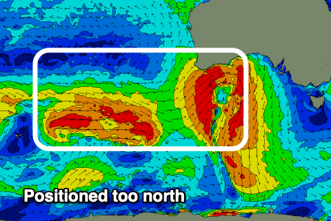
As touched on in the last couple of updates, the rest of the week looks void of swell with the storm track being too westerly and north in position to generate any significant swell for us next week. So I hope you made the most of today and try and get one in tomorrow morning. Have a great weekend!
Comments
Hi,
I just had a question about this swell. On Friday the swell train was at 6.6m at 14.7 s coming in at 229 SW. Yet the points were chest high to head height . Normally if a swell has any West in it, it usually takes a swell of above 8 metres for it to be that size at those locations. I could understand if the direction was 170 - 190, but at 229 it just seemed odd. I thought it would only be a decent wedge-size, it took me by surprise for waves to be that size on those harder to reach locations . What's your take on it?
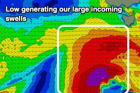
I never usually use the modelled direction as when there's lots of varying swells sources like with this close-range low, it mixes them up and doesn't show the true direction. I look at the core winds and where the storm is located to get a gauge on direction and this swell was not west as you can see in the image from Wednesday's notes..
Note the core winds.
Thanks Craig. Appreciate the reply. Cheers.