Large W/SW swell for the weekend

Southern Tasmania Surf Forecast by Craig Brokensha (issued Wednesday 18th December)
Best Days: Selected spots Friday morning, protected spots Sunday and Monday
Recap
Nothing of note yesterday and today.
This week and weekend (Dec 19 - 22)
Tomorrow will remain tiny, but a weak front moving in from the west and under us tomorrow has been upgraded a little more again since Monday, with a fun pulse of swell now on the cards for later tomorrow but more so Friday morning.
Winds will be onshore tomorrow ahead of a late kick in size to 1-2ft, with Friday morning seeing 2ft sets, easing through the day. Winds will freshen from the NE tending E/NE and becoming stronger into the afternoon, so Clifton won't be ideal.
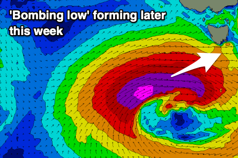
We then look to the 'bombing low' forming west-southwest of us later this week.
This low will just reach the requirements of a 'bombing' system with it dropping 24hPa in a 24 hour period, but it's forecast to bottom out to 953hPa while a strong high squeezing it to the north-west will come in at 1024hPa.
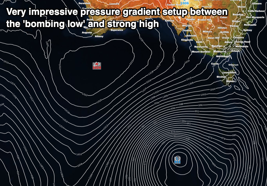
 This will see a significant fetch of storm-force W/SW winds generated in our western swell window on Friday, with the low moving slowly east while continuing to generate a fetch of severe-gale to storm-force W/SW winds in our western swell window Saturday.
Come Sunday we'll see the trailing edge of the low directing more favourable but weaker SW gales in our south-western swell window and then S/SW winds Sunday afternoon and evening.
What we'll see is a moderate to large W/SW groundswell for Sunday, with some weaker windswell likely showing late Saturday but with onshore W/SW winds.
Sunday will see strong W tending W/SW winds with the large W/SW groundswell coming in at 5-6ft across Clifton, much larger at more exposed breaks.
The swell should start easing Monday while swinging more SW-S/SW in direction, dropping from 4-5ft across Clifton. Winds on Monday look a little unfavourable and light and variable S/SE, freshening into the afternoon.
Tuesday looks to still be around 2-3ft but dropping and with fresh S/SW winds.
Longer term the outlook is tiny, so try and work the swell and local winds, taking into account the initial west direction.