More small westerly swells inbound

Southern Tasmania Surf Forecast by Craig Brokensha (issued Wednesday 20th November)
Best Days: Late morning tomorrow beginners, Sunday, Monday morning
Recap
Small to tiny levels of W/SW swell, swinging more SW today but mainly to 1-1.5ft.
This week and weekend (Nov 21 - 24)
The swell will shift a little more S/SW through tomorrow and ease, likely from 1-1.5ft if we're lucky though winds will be tricky and strong from the N/NE, tending variable late morning ahead of S/SE sea breezes.
We then look towards the W/SW swell due over the weekend.
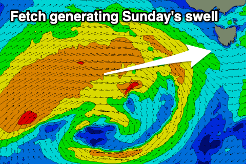 A strong and slow moving frontal progression is forming south-west of WA, with a fetch of W/SW gales being generated just on the edge of our swell window. This should produce an inconsistent W/SW groundswell for later Saturday and Sunday, but the secondary developments of this storm closer towards us later this week and Saturday should produce a more reliable mid-period W/SW swell Sunday.
A good fetch of strong W/SW winds will be projected east, eventually across us Saturday evening.
Size wise, Clifton will be tiny Saturday morning, building later to 1-2ft and peaking Sunday to a good 2ft with afternoon W/SW breezes on the former and great N/NW tending variable winds Sunday ahead of late sea breezes.
Monday looks clean again as the swell eases back from 1-2ft.
Longer term, tinier W/SW swells are on the cards for next week, but more on this Friday.