Moderate sized westerly swells

Southern Tasmania Surf Forecast by Craig Brokensha (issued Wednesday 13th November)
Best Days: Thursday, Friday, early Saturday, early Sunday, Monday morning
Recap
Building surf from the W/SW through yesterday with winds remaining favourable for protected spots most of the day, with a peak in size today to 3-4ft with protected spots again fairing best. Winds have now shifting onshore from the W/SW.
This week and weekend (Nov 14 - 17)
The low and fronts linked to our current swells have moved off to the east and with this we'll see the swell easing through tomorrow.
Clifton should see 3ft sets, dropping through the day with a great N/NW tending W/NW breeze.
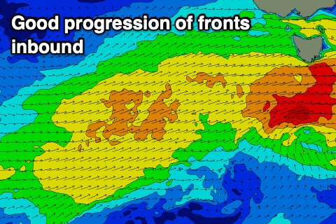 From here we'll see plenty of mid-period W/SW swell filling in from Friday through Sunday as back to back fronts push in from the west.
The conveyer belt of activity won't be especially strong but we should see good fetches of strong to near gale-force W/SW winds in our swell window, with the final front passing under us on Saturday evening.
We should see Clifton coming in at an easy 3ft on the sets out of the west on Friday (more so into the afternoon), easing a little back to 2-3ft on Saturday and holding 3ft Sunday morning out of the SW before easing.
Winds will strengthen Friday, light NW early and strong W/NW into the afternoon, with dawn W/NW winds Saturday, shifting W/SW mid-late morning. Sunday looks similar but with weaker winds, W/NW early before shifting SW.
Following this activity the outlook goes quiet so make the most of the coming days.