Fun tomorrow, then large and windy surf developing next week

Southern Tasmania Surf Forecast by Craig Brokensha (issued Friday 24th May)
Best Days: Saturday, protected spots Tuesday afternoon, protected spots Wednesday and Thursday
Recap
Tiny surf yesterday to 1-1.5ft and similar today when some better W/SW energy should be building to 2-3ft. Cape Sorell has since risen and winds are still offshore so hopefully there is more size this afternoon.
Today’s Forecaster Notes are brought to you by Rip Curl
This weekend and next week (May 25 - 31)
A better aligned SW swell is due tomorrow morning, generated by a better aligned fetch of strong to gale-force W/SW winds in our swell window during the middle of this week. We should see 2ft to possibly 3ft sets tomorrow morning, easing through the day with a persistent N/NW offshore.
 The surf will then bottom out into Sunday and remain tiny to flat until Tuesday and more so Wednesday/Thursday next week.
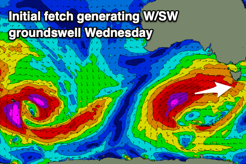
A strong and pronounced node of the Long Wave Trough will develop and stall across the south-east corner of the country, projecting a vigorous polar front progression up towards Victoria and South Australia, initially in our western swell window.
An initial broadening and lengthening fetch of severe-gale to storm-force W/SW winds will be projected through our western swell window on Monday and Tuesday, generating a moderate sized long-period W/SW groundswell for us Wednesday, building through the day. Ahead of this on Tuesday though we'll see mid-period W/SW swell building from a strong to gale-force W/SW fetch moving under us. Building surf to 2-3ft is due later in the day, small in the morning with strong W/NW winds.
 The groundswell should build through Wednesday and reach 3-5ft across Clifton, much larger at more exposed breaks but with strong W/SW tending S/SW winds.
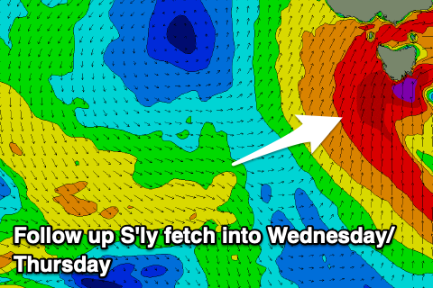
This shift in wind will be associated with the frontal progression sliding a touch east, projecting gale-force S/SW winds up and into us, generating an additional S/SW swell for Thursday that looks to at this stage come in at 5-6ft, easing through the day along with strong S/SW tending SW winds.
Following this the swell looks to ease slowly out of the S'th with SW tending W winds, but we'll have to go over this again on Monday. Have a great weekend!