Fun swell to end the week, larger and windy next week

Southern Tasmania Surf Forecast by Craig Brokensha (issued Wednesday 22nd May)
Best Days: Friday, Saturday, Sunday morning beginners, Tuesday and Wednesday
Recap
A strong kick in S/SW groundswell Monday afternoon, easing back from 2ft yesterday morning, a bit quicker than anticipated and 1-1.5ft today.
Today’s Forecaster Notes are brought to you by Rip Curl
This week and weekend (May 23 - 26)
Tomorrow will be tiny most of the day but later in the day and more so Friday our new W/SW groundswells are due to fill in, generated by a slow moving and strong polar low that's currently sitting south of WA.
The best aligned fetch in our swell window is being generated now, with it slowly projecting east this evening and tomorrow morning before weakening. This should keep wave heights up into Friday afternoon and Saturday morning before easing.
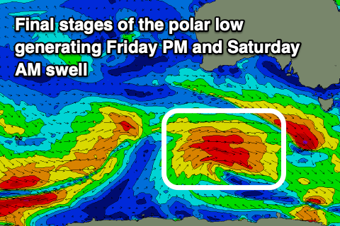 Size wise Clifton should see 2-3ft sets out of the W/SW Friday morning, becoming more consistent into the afternoon and evening and easing from 2-3ft Saturday from a more SW direction.
Winds will be great with a N/NW tending variable breeze Friday and then N/NW all day Saturday as the swell eases. Sunday looks tiny but clean and ideal for beginners.
The surf will remain tiny until Tuesday/Wednesday next week when a strong and pronounced node of the Long Wave Trough establishes itself across the south-east of the country.
This will project a broad, elongated and very strong polar front from the south-west of us up towards Victoria, in our western swell window. The front will remain slow moving and shift more east through early next week but remain in our western swell window, generating a moderate to large sized W/SW groundswell that is due to build Tuesday and peak Wednesday at this stage but with lots of wind. More on this Friday though.