Small S/SE swell ahead of more activity later week and next week

Southern Tasmania Surf Forecast by Craig Brokensha (issued Monday 6th May)
Best Days: Wednesday at south-east swell magnets, Sunday morning, Monday
Recap
Average conditions over the weekend with a windswell building through Saturday and onshore small bumpy 1-2ft waves yesterday, tiny and still onshore today.
Today’s Forecaster Notes are brought to you by Rip Curl
This week and weekend (May 7 - 12)
Tomorrow will be tiny and with variable winds again through the morning, while our small pulse of S/SE groundswell for Wednesday is still on track.
This was generated over the weekend by a significant fetch of polar severe-gale to storm-force SE winds, with Clifton hopefully seeing inconsistent 2ft+ sets through the day, fading Thursday.
Winds look favourable and offshore out of the N/NW, tending more W/NW through the day ahead of a late gusty W/SW change as a cold front moves across us.
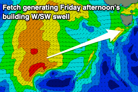 No swell is due off this front, but a secondary system firing up on its tail looks to generate a better W/SW groundswell for Friday. A fetch of strong to near gale-force W/SW winds will be aimed through our western swell window, with an increase in size to 2ft due into Friday afternoon, tiny early.
Unfortunately it looks like a deepening low forming late while moving across us will bring onshore winds and poor conditions.
Saturday looks to remain onshore as a secondary front moves in and brings SW winds, while from Sunday and more so early next week we've got a better mix of groundswells and back to back energy on the cads.
The first in a progression of strong polar fronts will fire up in our swell window south of WA later this week, with an initial fetch of severe-gale W/SW followed by a broader and more elongated fetch of W/SW gales.
We should see an increase in size Sunday morning ahead of a larger groundswell later in the day, easing Monday.
Size wise Clifton should build from 2-3ft to 3ft+ later in the day Sunday with with NW tending W/SW winds, easing from 3ft Monday with NW winds.
Behind this we'll see further fronts firing up, but more on this Wednesday.