Tiny swell to end the week, strong swells for Sunday and Wednesday

Southern Tasmania Surf Forecast by Craig Brokensha (issued Wednesday 10th January)
Best Days: Exposed breaks Friday, Sunday morning, Wednesday
Recap
Tiny waves with average winds the last two days.
Today’s Forecaster Notes are brought to you by Rip Curl
This week and weekend (Jan 11 - 14)
Tomorrow morning is expected to start tiny and with less than ideal N/NE tending fresher E/NE winds, but into the afternoon and more so Friday we should see a new W/SW groundswell filling in.
Sets to 1-1.5ft are due, but more exposed locations will be the pick with the E/NE breeze Thursday afternoon and gusty N/NE winds Friday (giving into a late W change).
The swell will fade Saturday with less than ideal W/SW tending S/SW winds, while some new SW swell is expected on Sunday morning, generated by a southward but strengthening low developing west of us on Friday.
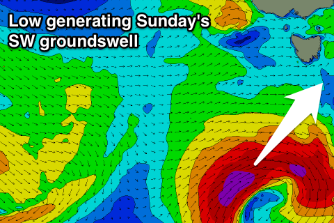 We'll see this low generating a great fetch of gale to severe-gale W/SW-SW winds in our south-western swell window, but the southward track isn't too ideal.
Still we should see a good long-period S'ly groundswell generated for Sunday, coming in at 2-3ft.
Winds on Sunday are still a little suss and could be onshore, so check back here Friday for an update on this.
The swell is expected to ease into early next week from 2ft though winds look onshore.
Longer term and we're set to see some good groundswell mid-next week as a 'bombing low' forming in the Southern Ocean south-west of WA weakens but traverses along the polar shelf through our swell window before being steered back north towards New Zealand.
A moderate sized mix of swells are due Wednesday with favourable winds, but more on this Friday.