Lots of swell for the coming period

Southern Tasmania Surf Forecast by Craig Brokensha (issued Monday 25th September)
Best Days: Wednesday, Thursday morning, Friday morning, Saturday afternoon, Sunday, Monday
Recap
An ideal weekend for beginners with tiny clean surf. A small low moving across us today has generated a small increase in S/SW windswell but with onshore winds.
This week and weekend (Sep 25 – Oct 1)
The swell off the low pushing across us today is due to ease back rapidly into tomorrow with no real trailing fetch of sustained winds behind it. We may see 1-2ft sets early, easing through the day with a morning W/NW-NW offshore.
We've got some better S/SW groundswell due into Wednesday though, produced by a strong polar front that's currently south-west of us.
A polar fetch of gale to severe-gale W/SW winds are being generated and we should see the swell build Wednesday and reach 2ft+ by late morning, easing from a similar size Thursday morning.
Winds on Wednesday will be offshore through the morning before tending fresh N/NE into the afternoon and then NW tending W/SW winds Thursday.
 Moving into Friday and a small mid-period W/SW swell is due, produced by a weakening polar front projecting towards and over us through the middle to end of the week.
We should see the surf continuing around 2ft with all day offshore NW winds as a much stronger polar low approaches from the west.
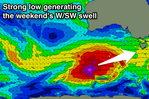
Now this system, mentioned the last few updates will form under the influence of a strong node of the Long Wave Trough, with a fetch of severe-gale to storm-force W/SW winds forecast to be projected through our western swell window late week.
We should see some new mid-period W/SW swell for Saturday morning with the groundswell proper arriving into the evening and easing Sunday.
Clifton should see 2-3ft surf Saturday morning, building towards 3-4ft late in the day, easing from a similar size Sunday morning.
Winds on Saturday morning look poor and gusty out of the W/SW, but another front approaching during the day will steer then offshore from the W/NW most of Sunday.
Longer term the secondary frontal activity is due to generate plenty more surf into the following week, but more on this Wednesday.