Tuesday/Wednesday best of the period

Southern Tasmania Forecast (issued Monday 30th June)
Best Days: Tuesday morning, Wednesday
Recap
There wasn't much left of Friday's well into Saturday with a tiny 1-1.5ft wave leftover across Clifton.
Sunday saw a messy windswell developing mixed in with a S/SW groundswell and onshore winds. Both swells held well into this morning but W'ly winds limited options.
This week (Jun 30 – Jul 4)
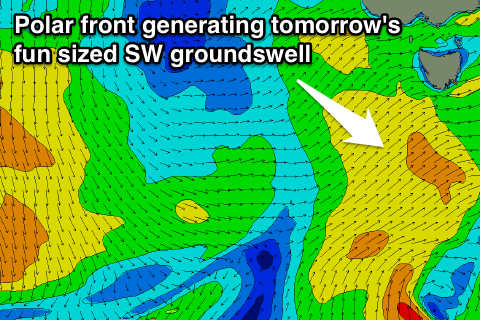 The frontal system responsible for today's swell has been followed up by a secondary better aligned polar front and this should generate a good 3ft of swell across Clifton tomorrow, peaking through the morning.
A drop in size should be seen into the afternoon and further Wednesday from 2ft or so and then from here onwards there's nothing really significant on the cards for the rest of the week. Some tiny and inconsistent S/SE swell may be seen to 1ft, but this won't offer any swell of consequence.
Winds tomorrow should be similar to today, with an early W/NW'ly ahead of a shift to the W/SW during the day, while Wednesday looks good all day with a fresh NW tending W/NW breeze.
This weekend onwards (Jul 5 onwards)
The weekend isn't looking too good with some inconsistent S/SE groundswell due to persist Saturday, generated off the southern flank of a low stalling under New Zealand. Some tiny W/SW groundswell is also likely to be in the mix, but both aren't expected to top 1ft+.
Longer term the storm track will remain focussed north of our ideal swell window right through next week. We may see some swell late next week/weekend as a strong node of the Long Wave Trough moves in from the west, but we'll review this Wednesday.