Stormy swell building Sunday, cleaner Monday/Tuesday morning

Southern Tasmania Forecast (issued Wednesday 25th June)
Best Days: Early Saturday for beginners, Monday morning, Tuesday morning, Wednesday
Recap
The surf remained tiny yesterday but a late increase in W/SW groundswell should have been seen and this swell peaked this morning to a good 3-4ft across Clifton under offshore winds.
Conditions remained clean all day as the swell slowly backed off and there isn't due to be much size left tomorrow morning.
This weekend onwards (Jun 28 onwards)
There isn't expected to much of today's swell leftover tomorrow with an easing 1-2ft due across Clifton under fresh N'ly tending N/NW winds.
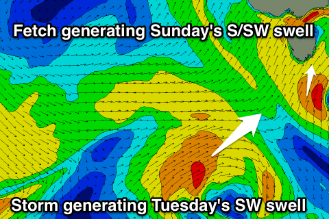 Sunday's kick in S/SW windswell has been upgraded since Wednesday with the system passing over us now forecast to aim a fetch of strong to gale-force S/SW winds into the southern part of the state.
This should kick up a solid increase in S/SW swell Sunday afternoon but with strong SW winds to 3-4ft.
The front will quickly race off to the east with a rapid drop in size expected into Monday morning from 2-3ft, but a secondary polar front quickly pushing up into us should generate another pulse of SW groundswell for the afternoon and Tuesday to 3ft again (right).
Winds Monday morning should be good and from the W/NW but the front will bring a SW change.
Tuesday when the swell peaks should be clean again with a morning W/NW'ly ahead of a shift to the W/SW through the day.
Wave heights are expected to ease into the end of the week and beyond this there's nothing too major on the cards besides some possible funky S/SE groundswell again, but we'll review this Monday. Have a great weekend.