Great swell and winds Friday

Southern Tasmania Forecast (issued Wednesday 25th June)
Best Days: Later Thursday, Friday, Saturday morning, early Monday
Recap
Tiny surf continued through yesterday, but today a slight increase in acute W'ly swell was seen but to no major size.
This week (Jun 25 - 27)
Late tomorrow's and Friday's W/SW groundswell is still on track with the vigorous frontal system generating the swell currently sitting south of the Bight.
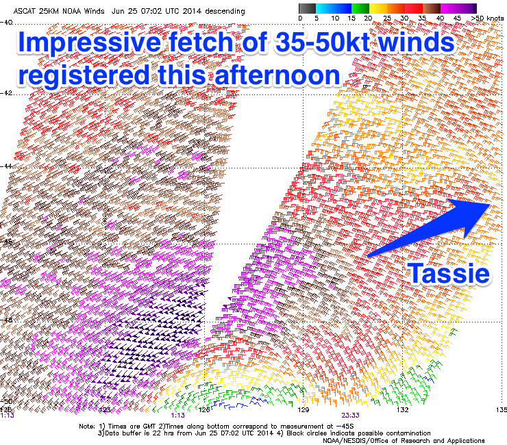 Satellite observations have already measured an impressive fetch of 35-50kt winds aimed towards us and we'll continue to see winds of this strength produced overnight before the system pushes over and across us tomorrow.
A late increase in size is due tomorrow 2-3ft on dark across Clifton, but Friday morning should see solid 3-4ft waves across Clifton at the peak of the swell ahead of a drop into the afternoon.
Conditions are looking excellent as well with N/NW tending N'ly winds, favouring a wide range of locations.
This weekend onwards (Jun 28 onwards)
Friday's swell will dip considerably overnight and only a small 1-2ft wave is due on Saturday morning as winds persist from the N/NW.
Sunday's mix of swells are still on track, with a polar low expected to generate 2ft of S/SW groundswell for the afternoon, but a mid-latitude system pushing across us at the same time will kick up a S/SW windswell. Size wise Clifton should increase to 2-3ft but with fresh to strong SW winds.
A short period of cleaner conditions is due Monday morning ahead of another strong SW change and with a leftover 2ft of swell.
The change on Monday will be related to a polar front pushing up past us and while not especially strong it should kick up a good 2-3ft of S/SW swell for Tuesday before easing off Wednesday. Winds look average though and generally from the SW but we'll confirm this Friday.