Plenty of south swell ahead, then an ECL next week

South-east Queensland and Northern NSW Surf Forecast by Ben Matson (issued Wednesday 8th July)
Best Days: Thurs: plenty of S'ly swell (easing Fri) with generally light winds. Biggest in Northern NSW, only small in SE Qld but some fun waves. Sat/Sun: small waves, generally OK winds. Mon/Tues/Wed: small, fun NE tending E/NE swell for most open beaches (i.e. SE Qld, Far NNSW) with generally offshore winds (gusty in the south). Tues onwards: large swell event developing from the SE, though initially aimed towards southern locations. Smaller in the north, with a later arrival time.
Recap: Easing S’ly swells to 3-4ft on Tuesday rebuilt today with more consistent 4ft sets at south facing beaches south of Byron. It’s remained much smaller north of the border as is expected under southerly swell regimes. Conditions have been OK for the outer points and sheltered spots with mainly SW tending S’ly winds.

Small Wednesday morning lines at The Pass
This week (July 7 - 10)
Although today’s expected size increase came in just at the bottom end of forecast expectations, I’m holding generally steady with the outlook for Thursday as I feel the longer period energy is yet to show properly, and will probably muscle up a little overnight ahead of a gradual easing through the day.
As such, south facing beaches south of Byron should see inconsistent 3-5ft sets (smaller at southern ends), and conditions will be nice and clean with light offshore winds and weak afternoon sea breezes.
Across SE Qld, we’ll see much smaller surf, but the outer points should pick up inconsistent 2ft+ sets and exposed northern ends/south facing beaches should manage 3ft+ sets at times. However, we’ll be at risk of lingering S’ly winds here, mainly on the Sunshine Coast but early SW winds are also likely to swing S’ly on the Gold Coast through the day - not too strong but enough to cause issues at exposed beaches.
Wave heights will then ease in the afternoon (Mid North Coast, probably not until overnight north from Ballina) and continue a slow abating trend through Friday with generally light variable winds across all regions. SE Qld should pick up a small short range SE swell from a ridge in the Coral Sea, though we’ll be lucky to see much more than a peaky 2ft+ set at exposed northern ends (smaller on the outer points).
Northern NSW’s south facing beaches should still manage some 3ft+ sets early morning (smaller elsewhere) but conditions will be generally clean. Expect a little less size through the day.
This weekend (July 11 - 12)
Northerly winds are still a risk for parts of the Mid North Coast on Saturday, but they’ll become light on Sunday. We’ll see generally light winds all weekend elsewhere, though out of the north if anywhere so aim for the northern corners for the best conditions (early mornings should be light and variable).
Friday’s easing S’ly swell will continue to abate into Saturday, down to 2ft+ at south facing beaches south of Byron early morning, smaller into the afternoon and on Sunday.
A small long period S’ly swell glancing our region overnight Saturday may lift south facing beaches into the 1-2ft range on Sunday, however most beaches will remain very small indeed.
Otherwise, a weak easterly fetch atop a modest Tasman high may generate some minor E’ly swell for our region both days, but there probably won’t be much more than stray 2ft sets across exposed beaches.
So, keep your expectations low this weekend, but there’ll probably be small options at exposed beaches if you’re keen.
Next week (July 13 onwards)
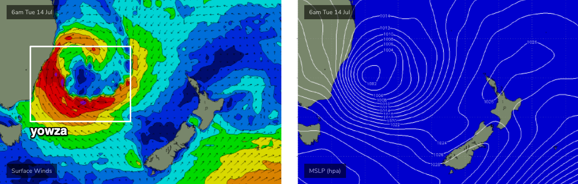
Looks like the ECL tipped in Monday’s notes is going to eventuate next week (see below). And therefore, we’re looking at some pretty large, windy surf for parts of the East Coast - though the biggest surf will happen in Southern NSW and it’ll be smaller as you head north.
The position of the low close to the mainland will create different wind directions north and south of the low’s axis (probably near Sydney). Anywhere to the south will see gale to storm force SE winds, close to the low will be S’ly tending SW, but north of the axis - across Northern NSW and SE Qld - we’ll see gusty W/NW tending W’ly then eventually SW, though the most strength will be found further south, closer to the low. Monday may also see a period of early N’ly winds.
As for surf, we’ll initially pick up a NE tending E/NE swell from Monday onwards, sourced from a tropical infeed into the developing low (from as early as Sunday night). This could briefly spike to 3ft+ on Monday but will probably level out at 2-3ft through Tuesday and Wednesday. This is an important swell source for SE Qld because the early stages of the ECL won’t favour anywhere north of the border (see below).
In contrast, Northern NSW - specifically the Mid North Coast - will see building E’ly tending SE swells from some time around Tuesday onwards, maybe Wednesday depending on how the low evolves - it’s a tricky system to pin down right now. But, at the height of the swell we’re looking at very large waves in the 12-15ft range across some parts of Southern NSW, that will grade smaller as you head north - probably 8ft+ across the Mid North Coast and 6ft+ across the Northern Rivers. Current expectations are for a peak around Wednesday or Thursday or thereabouts.
Across SE Qld, we’ll see much smaller wave heights from this ECL, and a further lag in arrival compared to southern locations. So at this point in time, we need to be cautious in our expectations because this will primarily be a Southern NSW event. As such, expect smaller conditions for the first half of next week but with the potential for stronger S’ly thru’ SE swells mid-late next week.
Let’s see how Friday’s models are resolving this situation, so that we can hone in on specific windows of opportunity.
See you then!
Comments
Some nice waves around today.

Was junky unorganized and pretty crap where I checked this morn. Only 1 point looked good everything else was meh
crowded gurgle
It's been a good week down here...one spot open to south swell has got an all time bank :-)