Make the most of the weekend

South-east Queensland and Northern NSW Surf Forecast by Craig Brokensha (issued Wednesday 17th July)
Best Days: Tomorrow and Sunday morning regional south magnets
Recap
Great conditions yesterday with the swell easing back to the 3-4ft range across most of NSW, with small waves on the south magnets in QLD.
Today a new S'ly groundswell pulse pushed up the coast, kicking to a solid 4-5ft across most exposed breaks in NSW, though magnets saw easy 6ft sets into the late morning as the swell muscled up. Conditions were great again ahead of weak sea breezes, continuing the run of good surf this week.
Today’s Forecaster Notes are brought to you by Rip Curl
This week and weekend (Jul 20 - 26)
These notes will be brief as Ben’s on annual leave.
The trend from now through the weekend is down.
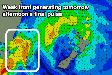 Today's pulse of S'ly groundswell will back off slowly through tomorrow, owing to the front generating it being slow moving through our swell window yesterday.
We should still see 4ft sets across south magnets in NSW tomorrow morning, though possible more 3-4ft across the Mid North Coast. The Gold Coast will be mostly 1-2ft, with the odd bigger one across the regional magnets.
A weak front pushing up into the Tasman Sea today will produce a reinforcing mid-period S'ly swell for tomorrow afternoon but this will just slow the easing trend.
Sunday looks to ease further from 3ft to possibly 4ft across northern NSW south swell magnets, smaller and to 3ft on the Mid North Coast and small to tiny in Qld.
Winds will be favourable for most spots and light W/NW across the MNC, W/SW in northern NSW and S/SW on the Gold Coast, becoming variable and weak sea breezey into the afternoon (NE on the MNC).
Sunday's winds will be great for the south magnets with a morning NW-N/NW offshore ahead of moderate to fresh N/NE sea breezes.
Looking at next week and there's nothing significant on the cards with a couple of small and flukey swell pulses.
A weak fetch of S/SE winds off the southern tip of New Zealand's South Island will generate a small S/SE swell for Tuesday but not above 2ft across NSW.
Winds will be favourable and offshore in the morning ahead of sea breezes.
The models are picking up a distant E/SE groundswell signal in the absence of anything else mid-week, but the source of this can't be determined, being somewhere in the South Pacific Ocean. Therefore I'd disregard this.
A weak trough moving off the southern NSW coast on Wednesday looks to generate a small and weak S'ly windswell for later Thursday and Friday morning but only to 2-3ft or so. Therefore make the most of the weekend's waves. Have a great weekend!
Comments
My kahuna friend says a distant easterly swell will light up my local break this week.