East swells for the entire period, but tricky winds will offer small windows of opportunity

South-east Queensland and Northern NSW Surf Forecast by Ben Matson (issued Friday 8th February)
Best Days: Plenty of east swell for the entire period, but with tricky winds. Early Sat, early Mon and then Wed/Thurs look the pick (mainly because of the local winds), with longer term swell prospects better all round.
Recap: Stacks of E’ly swells, building from 3ft Thursday to 4ft+ today, though onshore winds have kept conditions below average. There’s been pockets of light variable winds though, and everywhere saw an easing in wind speeds from yesterday into today. Surf size has been smaller south from Ballina.
This weekend (Feb 9 - 10)
Today’s Forecaster Notes are brought to you by Rip Curl
The synoptics are incredibly complex at the moment. Broadly speaking, the trade flow that generated today’s increase is throttling back so wave heights will ease over the weekend.
However, other regions of our eastern swell window have been active over the last few days, and will remain active into Saturday so this will otherwise arrest the easing trend and maintain plenty of size across exposed coasts.
Without eyeballing each individual fetch and then assessing not only its own potential, but the potential offered by way of its interaction with other swell trains, let’s just keep things nice and broad. The reason we can do this is because we’re not expecting a distinct change in the character of the surf: for example, the arrival of long period E’ly or SE energy, in the form of a defined swell front.
As such, we’ll see similar kinds of swell over the weekend as what we’ve seen over the last few days, just a gradual easing in the size department.
The only caveat I’d make there is that - and the models aren’t picking this up - the southern flank of a broad trough north of NZ today is strengthening and the leading edge of the associated new swell may kick in late Sunday (though more likely Monday). So, expect abating size for most of the weekend but keep an eye out Sunday afternoon for a pulse.
Early Saturday should still be around the 3-4ft+ mark at exposed beaches in SE Qld and Northern NSW, Sunday morning will be closer to 3ft. Both days will see smaller surf across the protected points.
As for winds, a southerly change will reach the lower Mid North Coast overnight Saturday and push north across our coasts during Sunday morning.
Prior to this, Saturday will see freshening N’ly winds - mainly affecting locations south from Ballina, though early morning should offer a window of light variable winds (with a longer duration north from Coffs than south). The afternoon’s winds will create issues across most of Northern NSW and maybe up into the Gold Coast late, but it shouldn't be too strong across the Sunshine Coast. So, aim for an early paddle.
The S’ly change is expected into Ballina around 8am (earlier to the south, later to the north) though won’t reach the Sunshine Coast until early-mid afternoon, and with a little less strength than its southern counterparts. We’ll see a small S/SE windswell build in the lee of the change but no great size is expected; apart from a brief window of beaches in the north around dawn, you’ll have to hit up the sheltered outer points for small clean waves on Sunday.
Next week (Feb 11 onwards)
The South Pacific synoptics are very tricky.
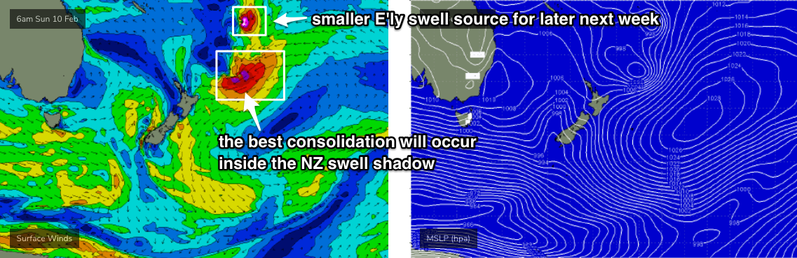
We’ve got a complex scenario unfolding north from New Zealand, though I’m not quite as confident on the consolidation of several tropical lows (and maybe tropical cyclones) within our swell window.
To be clear: they’re going to consolidate very well at some point, and New Zealand is gonna cop a hiding as a series of large NE and E’ly swells make landfall. However, the best consolidation is now more likely to occur once it slips into New Zealand’s swell shadow (see chart below), which reduces our surf potential considerably.
As such, we’re looking at an extended run of small to moderate E’ly swell as each system moves south through the swell window. The first swell will probably be the best, mentioned above for a possible early arrival late Sunday - originating from the southern flank of an existing trough just north of NZ, which is almost stationary.
Wind speeds are not overly strong, but the fetch is broad and long, and we should see 4-5ft surf from this source building Monday, peaking Tuesday and easing Wednesday.
Unfortunately, local winds look dicey as this swell reaches a peak.
Sunday’s southern change will ease rapidly to produce a window of light winds early Monday, but freshening NE breezes are expected Monday afternoon ahead of moderate to maybe fresh N’ly winds through Tuesday as a southerly change approaches the region. There’s a suggestion for a small coastal trough to develop through Tuesday offering a brief window of light winds, but I’m not confident on this being enough to really clean up conditions. I’ll assess over the weekend and update in the comments below if anything interesting shows up.
Further pulses of long range E’ly swell are expected through the end of the week - from smaller though more intense tropical systems feeding down the NZ trough line - though they’ll be much less consistent and smaller in size by the time they reach the NSW coast, generally around the 2-3ft mark with extremely long breaks between the sets.
Wednesday onwards looks pretty tricky from other sources.
An intense cut off low will strengthen immediately south of Tasmania around Tuesday, poorly aligned for our region but with surface winds likely to be north of 60kts at the core of the low, we’ll see small long period energy brush the NSW coast, in addition to mid-range S’ly swell from gale force SW winds exiting eastern Bass Strait. However this will probably favour Southern NSW over Northern NSW.
I’ll assess size potential on Monday but at this stage, Wed/Thurs could see 3-4ft sets at reliable south swell magnets south from Byron.
As for conditions, a stationary ridge looks like it’ll push S/SE winds across most coasts from Wednesday through Thursday - so the outer points look like being your best bet mid-late week as Tuesday’s E’ly swell eases.
Looking further ahead, and a renewal of E’ly groundswell is expected into the long term, from the same broad scale monsoon pattern that’s generating the energy expected next week.
However, the difference this time around is that these systems are much more likely to move westward through the north-eastern Tasman Sea, and have a greater chance at delivering larger, stronger and more sustained groundswells for the entire East Coast - from about Friday next week onwards, but with the potential for really juicy surf through the early middle part of the following week.
More on this in Monday’s forecast. Have a great weekend!
Comments
I'm just glad that finally we're seeing a change in the local winds. This will help warm our inshore waters and reduce overnight land temps, opening up more windows of opportunities for overnight S/SW winds to kick in and clean up the mornings surf.
No discussion on the tropical low in the coral sea reformation either? GFS not really interested. EC hinting at a possibility but bugger me Access G looking very tasty!!
UKMET interested somewhat also.
AccessG has been on crack all summer. I can't take it seriously.
But all models are showing something extre......no , I'm not saying it.
Did you say Extreme? now youv'e done it!
Exit stage left ;)
not a word ....but I'ver paid that many fucking dues surfing slop all summer my surf fitness is up to scratch
The lows are treading on each others toes.
So far over the last 6 months I can count the nunber of epic surf sessions on one hand. What a poor performance Gold Coast, shame on you.
The trend seems to be incremental downgrades. C’mon Huey, make this one count.
Good morning EC!! :)
And UK met even more interested now in a reintensification of this Coral Sea low mid next week.
Well fck me hey. Access G was the one to paint if early on and now GFS is coming on board with the reintensification of the Coral Sea low pressure system. And my god, take a look at the long range EC chart from this evening!!!!!!!!!!!!!!!!!!!!!!!!!!!!!!!!!!!!!!!!!!!!!!!
And UKMET showing similar signs long term also.
Watch this space....................
You’re all over it Don. How many models do you generally look at? Do you have to pay any kind of subscription or all free?
Generally 3 models. Access G, GFS and EC. But when TCs are forecast I then read ukmet and JWTC.
All free.
So I’m assuming the bom interactive wave and weather model is Access. Would you mind if I asked which sites you preferred for EC and GFS?
https://www.ecmwf.int/en/forecasts/charts/catalogue/medium-mslp-wind850?...
http://www.weatherzone.com.au/models/?lt=wzcountry&lc=aus&mt=gfs
http://www.weatherzone.com.au/models/?lt=wzcountry&lc=aus&mt=accessg
You’re a legend mate, thank you
Better than expected this morning, mid tid glass off with gorgeous 3 foot+ peaks
Finally some winds with a "W" in it this morning on the SC ... couple of fun ones
Inshore water temps starting to rise and overnight land temps dropping slightly. It should get even better after that S'ly change comes through on Sunday.
Let's hope so Don, can't be glad enough to see the back of that overnight easterly pattern
Very fun waves this morning. Snuck into a few pits and we were lucky to have 3 ft waves with quite a few 4fters coming through. 3 hour session has cooked me though :)
Models fallen flat, i think it's a long standing issue that they often see any type of circulation and spin them up as a cyclone or major system, especially GFS.
Fun again this morning, crowd was out tho
Really fun 4ft peaks northern end of Sunny Coast this morning. Good sandbank, offshore winds, low tide. Was surprised at the total lack of crowds for a Sunday, just made the most of it
Little slice of heaven just now.
Blue skies , blue water of the most delicious temperature and not another soul around as we bodybashed and flopped in the shore break.
Laying on the sand , getting salty skin kissed by the sun . A south wind ruffling the hair and tempering the blaze of the day. Watching the black shadow of a sea eagle flashing over the white of the sand. Inscribing circles with fingers in the wizened crust of the tide line.
Outdoor shower and crack the top off a cold coopers.
Now what to listen to ? That is the question.
Magic.
I would guess there was no lack of crowd at the points. Which is great for the beach breaks. I feel a bit cooked though.
Fun waves for a change, but man it was crowded out there!
Looks pretty chunky this AM, already some 4ft sets on the Tweed.
Felt different to have that south swell in the water today. Been such a long spell of east. Longer lines, sweep. Fairly junky though
Did the east pulse happen a little later than predicted. Definetly wasn’t in the water at dawn on the north sc
pfffffffttttt..................
Offshore junky , then early into the piece became onshore junky.
Couple of lids out . Noticed a few mullet in the shorey , so had a flick instead resulting in a nice flathead. Gave it to a couple of pensioners catching fuck all to boost the karma account.
Not sure if the flathead was too enthused with the whole situation.
Red weed is back.
That was one of the most pissant S'ly changes in history yesterday, well since the last one.
One day, half a day actually.
Then back to roasting hot N'lies.
^ Ha, in Sydney it's been great to have the cooler crisper air from Friday evening through until this morning. Only a couple more days Steve..
Southerly didn’t blow much but what a change in water quality in a matter of hours on Sunday blue, warm ..... beautiful. But jeez that nor’easter is howling again now.
Norfolk Island must be directly in the centre of that big high pressure system out in the Tasman which is dominating the synoptic and it is suffering from lack of rain similar to the North Coast
https://mobile.abc.net.au/news/2019-02-11/norfolk-drought-feels-the-heat...
It’s procrastinating. Some good looking Synoptics every time I look, always half a week or more away, forever getting pushed back
chasing the dragon... it will ruin your life.
New notes up. Got sick of writing 'endless E'ly swells' but it looks like the theme will continue.
https://www.swellnet.com/reports/forecaster-notes/south-east-queensland-...