Difficult short term; exciting though windy long term with stacks of swell for the points

South-east Queensland and Northern NSW Surf Forecast by Ben Matson (issued Monday 11th February)
Best Days: Tues/Wed may see a slim window of NW winds early, otherwise N'ly winds are likely to ruin conditions. Thurs onwards will see a combo of swells, mainly out of the east then building SE over the weekend with an extended run of action on the points under fresh SE winds.
Recap: Easing E’ly swells on Saturday still managed 3-4ft sets early, and light morning winds gave way to freshening N’ly breezes throughout the day, strongest in Northern NSW (particularly the south). A gusty S’ly change extended across the region on Sunday morning with the E’ly swell maintaining size around 3ft. Today we’ve seen early light winds and afternoon sea breezes, and a slight increase in E’ly swell back up to 3-4ft, though the sets are rather inconsistent.
This week (Feb 12 - 15)
Today’s Forecaster Notes are brought to you by Rip Curl
I’m really not very confident in the surf outlook for the next few days.
Fortunately - from a forecast perspective - the threat of fresh N’ly winds both Tuesday and Wednesday eases the risk, as most locations are likely to be blown out.
Anyway, the source of our inbound E’ly swell didn’t perform quite as well as expected over the weekend, and seemed to shift a little faster into the swell shadow of New Zealand.
Additionally, the models seem to have erased all reference to any swell out of the east on Tuesday. Instead, they’re expecting the main swell front to kick in around Wednesday. This is at odds with my manual calculations.
Unfortunately, with no wave buoys in the central Tasman Sea to monitor the incoming swells and provide verification on their size and strength, we can only wait to see what transpires.
As such, I’m going to slightly downgrade the outlook for the next few days (from this swell window). The large travel distance coupled in with the poorly consolidated fetch (as detailed in last week’s notes) and then the greater-than-anticipated swell shadowing from New Zealand has really dented my confidence in this swell event.
We’ve seen today push into the 3-4ft range and we should see similar size surf into Tuesday, though apart from an early window of NW winds, expect most beaches to become blown out throughout the day with gusty N’lies.
The same goes for Wednesday across SE Qld and Northern NSW, but the Mid North Coast (early) and Northern Rivers (late) will feel the effects of a fresh southerly change throughout the day. There’ll be some short range S’ly swell trailing behind but it may not arrive until Thursday.
Based on model guidance, we should see a little more size out of the east later Wednesday and early Thursday (3-5ft open beaches) but again, I’m not especially confident that this will eventuate.
Thursday and Friday will then see a mix of swells impacting all coasts. In addition to the E’ly swell - which should ease from 3-5ft early Thursday down to 3ft by Friday - we’ll see a mix of S’ly swells; some short to mid range energy trailing Wednesday’s change, then some long period S’ly swell from the parent low south of Tasmania, arriving later Thursday and into Friday but only across Northern NSW.
We’ll actually see a new E’ly swell build during this time too, from a series of small tropical lows retrograding westward below Fiji. They look impressive on the synoptics and there’s certainly a chance for a mild captured fetch scenario but they’re also poorly consolidated. So I’m keeping my size expectations around the 3-4ft mark from this source (more so Fri than Thurs).
More importantly a strong ridge will become established across the region, driving fresh SE winds into all coasts (perhaps a slight delay on the Sunny Coast to begin with) and also generating a healthy short range SE swell, around 3-4ft at exposed beaches and smaller along the points.
This means conditions for the second half of the week will only be suitable for the sheltered points anyway, but with a blend of swells in the mix there’ll be plenty of options.
This weekend (Feb 16 - 17)
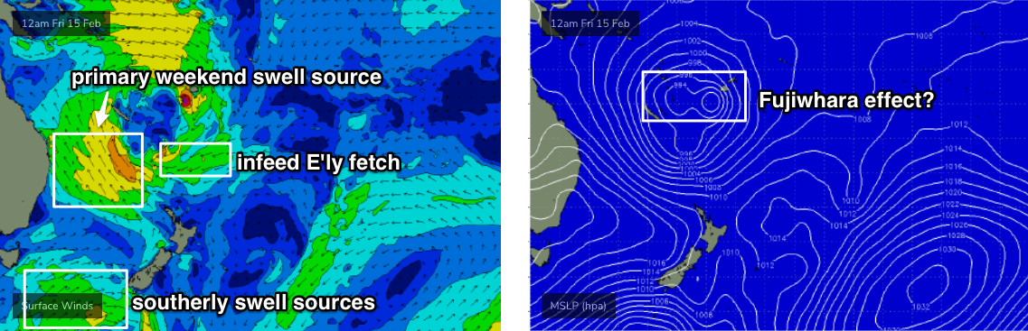
Some of the forecast charts are very impressive for the weekend, with a broadening ridge through the Tasman Sea combining with a widespread trough of low pressure to the north to create a large, strong SE fetch aimed into the Coral Sea.
On the surface charts it looks like one enormous low centred east of New Caledonia; this is mainly related to the broad scale circulation associated with the monsoon trough to the north. In fact there will be several small low pressure centres within the primary system, of which we may even see a ‘Fujiwhara’ effect later this week whereby two tropical lows or cyclones rotate around a central point.
However, not all models have the same setup to the same degree of intensity on the weekend’s synoptics, nor within the same part of the swell window either. As such we should be cautious about how high we set our expectations for the weekend.
As it is, there’ll be decent mix of easterly and southerly swells this weekend, from the same swell sources mentioned above.
However the primary fetch in the Central Tasman Sea will certainly be the dominant factor. At this stage it’d be pretty safe to call 5-6ft surf at exposed beaches in Far Northern NSW, with slightly smaller surf on the Mid North Coasts and across SE Qld. And, because of the SE swell direction, wave heights will be smaller again across SE Qld points, say around 3-4ft.
With fresh winds out of the SE just about everywhere, it’ll be points-only anyway.
Let’s see how Wednesday’s model runs are shaping up with this Tasman system, as there’s certainly the potential for an upgrade.
Next week (Feb 18 onwards)
Long term activity is centred around the South Pacific, with a multitude of tropical lows (and possible tropical cyclones) moving through our swell window at various points in time. Although there’s nothing concrete to pin down at this stage, it does look like we’ve got at least two or three weeks of persistent E’ly swell ahead as a series of tropical lows and tropical cyclones migrate across the South Pacific through our swell window. There is certainly a good chance for some very big easterly swell during the last week and a half of February.
Tune back in Wednesday to see how things have evolved.
Comments
Sigh...
Eh?
The comments from this Freeride76 dude pretty much sum it up.
Anyway, shot for the consistent and timely reports every week and every day. Good work.
Third(?) time this summer the synoptics have threatened to deliver something more than 3 ft gurgle.
Looks promising, but I'll believe it when I see it.
the broad tropical low pressure gyre is impressive in its own right though.
Yeehaa!! Definitely got the wave count up over the last few days and this looking great for more :)
Trying to imbed a screen shot of that gyre, it's a beauty.
Maybe not a perfect set up, but with plenty of wind shifts and different swell angles it's looking like an excellent time at last for N E coast surfing.
Why have surf reports become half an hour later than they used to be? Especially for this time of the year when the sun is basically up at 4:30...im paying money to use the service yet still have to rely on the free cams or drive
Mate, the time of sunrise changes throughout the year. Why? Because of the Earth's tilt on its axis.
For example, on the Sunshine Coast, First Light on December 21st is 4:24am, and Sunrise is 4:50am.
Today, First Light is 5:04am, and Sunrise is 5:28am.
That's 42mins later.
And, if I don't mind saying so myself, a pretty good excuse for "why the surf reports are half an hour later than they used to be".
hahahaha
nup its up at 5 now. getting later by the day
Can anyone remember the last time the long term promising outlook materialized into anything decent? Don't get me wrong the waves have been fun of late, but man when will one of these systems convert into clean overhead point waves? It's closing in on a year since my step up has wet it's rails...
Surprised at the consistently negative comments here about the forecasts. If I was a grom, this summer would have been one to remember, one to look back on in 20-30 years. There’s been consistent swell, and more on the horizon. Hardly a flat day in sight. Yes, the winds have been crap much of the time, but that’s summer.
Depends on your perspective of course.
The constant heatwave, dryness and onshore wind, in short the general toxicity of this summer, has overshadowed the general background hum of constant 2-3ft surf.
And the fact that the synoptics have kept lining up to really deliver and then downgrading back to mediocrity has been a constant theme.
Agree, in fact for me perspective and expectations are everything and often influence whether surfing is rip roaring fun or just frustrating, regardless of the conditions.
Agreeing with hamishbro. Summer has been really fun.
Great local banks, constant east swell. I've had at least half dozen amazing clean 3-4' peaky days without a soul in the water. Haven't surfed so much in 12 months.
Good for the paddle fitness when the solid swell does come. In saying that, I can only imagine what kind of circus all the regions points will be. Lets hope this system doesn't bust too many beach break banks.
We actually need some kind of major bank re-arranger down here.
Apart from one particular bank it's mostly smeg.
could be good for you guys
I don't think so.
We really need something from S of E to get the sand moving the right way.
Anything major from the E to ENE will likely compound the situation here. But you never know.
I was on the MNC last week and I surfed the main point at Crescent 5 days consecutively. Sure it was a bit bumpy at times and didn't get over shoulder height but I'll take it. The sand dependent points I checked looked pretty sad though...
Has anyone been up top at D-bah lately and seen which way the tidal plume from the Tweed on the outgoing tide is running?
Proof will be in the pudding, but the synoptics are looking pretty damn good for the next week or so. Just need one of those cyclones to aim dead on
Dont wish for something that you don't really want. Take a look at the latest super long range EC charts. Chaos if that thing comes to fruition.
Of course it's miles away in terms of forecast accuracy and there's a hell of a lot of tropical muck brewing up there in the short to medium term so it's likely a furphy but let's watch this space.
All long range models and UKMET onboard with a SW retrograde of some sort of tropical cyclone medium to long term.
Yeah this one looks like it could be legit. Looks like it's gonna sit pretty stationary and develop into something of a menace. Sand will move.
Where does one find " the latest super long range EC charts" what is UKMET, JTWC? Anyone know of a good sight to learn about such things?
There’s this website called Swellnet....
What exactly do you want to learn? How to read a weather chart?
Yeah, I have a basic understanding and several sites I check, including subscription to this one etc. Just would like to learn more
Anything in specific? Meteorology is a broad discipline. Always happy to take requests for future articles though.
Swell models?
Google is your friend for UKMET and JWTC.
Here's a site that has EC, GFS and GFS V3 (which I've not seen or used before). Links for Access G are also provided even though I posted them in the other forecast last week.
https://www.pivotalweather.com/model.php?m=gfs&p=sfcwind_mslp_cont&rh=20...
http://www.weatherzone.com.au/models/?lt=wzcountry&lc=aus&mt=accessg
Latest JTWC has confirmed cyclogenesis for low 96P.
track maps are all over the place.
Good luck forecasting the next 2 weeks.
Out of interest.. where do you think you could you surf the swell being created on the NW flank of TC Omar? Southern Hawaii?
Interesting question.
There's been so much strong NW to W monsoonal flow lately ...that would have to be generating some surf for somewhere.
Maybe the southern/south-western flanks of the Marshalls/Caroline Islands?
edit: sorry, I mean the western edges of some South Pacific islands.
The groundswell has kicked in nicely across northern NSW, but those winds..
And the Park Beach cam is back!

Another nuclear strength nor-easter, another heat-wave, another cold upwelling. Ballina looks like Birdsville.
Summer's been memorable alright, but not for surf.
This is the summer when the full realisation of what climate change will mean for the sub-tropics has been revealed.
We won't be spared by our traditional mild climate.
I used to think climate change might be alright. Few more cyclones, more surf.
Nope. Endless heatwaves, northerlies and upwellings.
Not to be a doomsayer, but the evidence is now getting very hard to ignore.
Have to agree with you I was on the fence until the last few years this weather in queensland for example has been absolutley disgusting maybe it is because I work outdoors but it has never bothered me in the past ! Could be just getting old and grumpy
Upwelling should fck off after today Steve. Autumn is fast approaching!!! :)
And there's a definite change in the charts, compared to what they've shown the last 2-3 mths.
It’s only one year .
You heard of a hundred year storm ? Well every weather pattern has extremes that fluctuate in severity and variance. Not saying the climate isn’t changing, just don’t think that you can set your expectations from a strange season or two.
This could be the one in a hundred years shitty Northerly summer.
I bet autumn is wet and pumping. ( Fingers crossed )
Today was insanely beautiful and pound for pound , the weakest waves I think I’ve ever surfed . Got expelled from the water due to boardshort induced hypothermia. Actually, not that cold .....but yeah , cold.
Geez, I dunno fellas, but this feels like summer from back in the late 70s n early 80s when I was a pre pubescent grommet on the MNC.
Memory serves it always felt like northerlies for days, bluebottles, red weed and cold water interspersed with sloppy swell and the always anticipated easterly or southerly pulse.
This summer, albeit I'm several hundred km further north, feels like a return to old .., my notes don't have another year around here when there has been as many bluebottles.
Feels like a return to old patterns. Geez, what a shame for all the climate change doomsdayers if nature, the universe was really the culprit and not our human impact.
Oops. Off topic. I'll put my tinfoil hat away. Ben, Stu, Steve, Blowin n Blindboy you know what I'm referring too... The trends are a changing and it's close the the bottom again. Get ready for the crunch. Last one was 2007/08.
Meanwhile across the dutch..
Serious fun at north sc last few days nice solid sets. Plenty of empty kegs too.... Behind the surf club.
9:30am and still no 8am GC update? I realise the surf sucks today but it feels like the morning forecasts are becoming increasingly inconsistent.
Hopefully this is a short term thing as I value those morning updates.
Probably the first time in a couple of years it's been missed. Sometimes, things happen - personal, technological, telco, etc - and they are missed. I'll check in to see what's going on.
Fair call. Definitely not the first time but no barbs intended. As a (happily) paying subscriber i'm just interested in receiving the service i'm subscribed to.
Completely understand these things happen - thanks for the response.
UKMET and EC and JWTC showing similar tracks, although EC and UKMET have more intensification compared to JWTC forecast. She's a compact little system which is always super hard for the models to get the forecast accurate. Can easily under or over deliver compared to forecasts.
JTWC forecasts the system to weaken just as it enters the swell window proper on the CS side of Grand Terre.
I don't know what to make of this.
I'm not pulling a 7'6" out from under the house, put it that way.
Never said it'll be 7'6" material.
Incrimental downgrades
No, I know Don.
I'm just riffing off what some of the potential outcomes have looked like from some of the model runs lately.
If we end up with another round of 3ft surf from a broad coverage of SE winds in the northern Tasman/central CS while Oma does the dance of the dying fly I won't be surprised.
Decided to hit the road early this morning and just had a fun and relatively uncrowded surf at the worst good wave in Australia.
Never been so stoked to see a southerly.
Bring it here please.
33.4 in Ballina, apparent temp 36.
My trusty little thermometer in the garden is reading 38.
40 in Lismore today.
It's fucking stifling.
Slowly creeping..
Oooohh, I like that Craig. Got a link for that chart/image?
You may need to be a silver member to view it.. I have a little click box that says "Obs Wind"
It's super useful for tracking changes and troughs.
http://www.weatherzone.com.au/radar/nsw/grafton
Thanks but I don't have the little click box!! Can you provide a new latest image? Looks like it's just hit Evans?
Between Coffs and Grafton according to the BOM obs.
For the nerds... looks like JTWC have come to a similar conclusion re: Fujiwhara effect.
In the FC notes above, I said:
"In fact there will be several small low pressure centres within the primary system, of which we may even see a ‘Fujiwhara’ effect later this week whereby two tropical lows or cyclones rotate around a central point."
JTWC have written:
GLOBAL MODELS ARE IN GOOD AGREEMENT THAT 93P WILL TRACK SOUTHWARD, BEGIN BINARY INTERACTION WITH 15P, AND GRADUALLY INTENSIFY.
http://www.metoc.navy.mil/jtwc/products/abpwweb.txt
Not quite what they say in the latest bulletin (not suggesting fujiwhara effect is implausible).
UPPER LEVEL ANALYSIS INDICATES THE SYSTEM IS UNDER STRONG
(30-35 KNOT) EASTERLY VERTICAL WIND SHEAR (VWS) THAT IS OFFSET BY
MODERATE POLEWARD OUTFLOW THAT IS PROVIDING VENTILATION TO THE
ASSOCIATED CONVECTION. SEA SURFACE TEMPERATURES (SSTS) IN THE AREA
ARE HIGHLY CONDUCIVE AT 30 DEGREES CELSIUS. A BUILDING SUBTROPICAL
RIDGE TO THE NORTHEAST IS CAUSING THE CYCLONE TO DRIFT SOUTHWARD
THEN, AFTER TAU 36, SOUTHWESTWARD TOWARD NORTHERN NEW CALEDONIA. THE
MARGINALLY FAVORABLE ENVIRONMENT WILL PROMOTE SLOW INTENSIFICATION
TO A PEAK OF 50 KNOTS AT TAUS 12-36. AFTERWARD, DIMINISHING OUTFLOW
AND COOLING SSTS, WILL GRADUALLY ERODE THE SYSTEM DOWN TO 40 KTS BY
TAU 120. THE NUMERICAL TRACK CONFIDENCE IS LOW IN THE NEXT 24 HOURS,
UNTIL THE SYSTEM BEGINS TO INCREASE SPEED AS IT TRACKS SOUTHWARD.
Looks like their forecast was updated since I posted (it is a dynamic link). Here's the original.
I think that text is a few updates old, we're up to warning No5 since it's been named as Oma.
Last few updates have all progged a weakening as it hits cooler SST's (clearly visible on temp charts) and insufficient outflow channels.
Strange day.
Wind is onshore with no hint of smoke , but it’s looked like the sky over Jakarta all day.
I’m cooked from this morning.....a couple of beers , a dopey grin and listening to some mellow tunes.
Make that a great day .
Must be from down this way, we had dust blow in with the westerly and then southerly, all brown and hazy across the skies this morning but not smokey.
hot as fuck here with dust haze, maybe some bushfire smoke mixed in.
looks and feels pretty apocalyptic to be honest.
Don't think that S'ly will get here until early hours at the rate it's moving.
Yeah just after midnight.
Yes it looks to have stalled around Evans
Time to run through the sprinkler.
Old school.
mate I've gone outside to the tap and had about three cold buckets over me already
if you haven't worked it out already I want to shove this summer into a potato bag with a brick and drown it.
Good idea.
Cold water in the bucket does make for a much smoother smoke.
15 days till autumn. Hang in there.
Then it’ll piss down relentlessly and it won’t be heat the North Coast is talking about .....it’ll be head rot .
Blowin, the “worst good wave”?! Can only be one spot in a southerly!
would have loved to have been there sliding a few.
Plenty of room today.
Norwester was making it ugly and empty as a consequence. Saw the south winds had hit down the coast and paddled out . Within half hour it was groomed.
One of the only times I’ve driven away without declaring jihad on the joint.
Fun enough , but it’d do your head in if you made a habit of it.
Sorry, running late today - FC Notes will be up around 7pm Qld.
Rather large about face from GFS tonight. JWTC appear to be having a bet each way with their forecast track between GFS and EC.
GFS has Oma stalled with her fetch on her SE flank fcking dissected by New Cal!!!!
I would actually pay money to read this forecast from Ben.
If there was a micropayment option I would do it.
Not because it will affect where I surf but just because it's so damn interesting and I want to read as many viewpoints as possible.
My gut is telling me it'll be at it's strongest on the wrong side of New Cal and wash out as it enters the CS. But that is a best guess.
I don't see any sufficient S'ly or SW'ly track to really do the business.
ASCAT pass shows TD 92 or 93 P starting to flare up so I guess there is still a chance of that fetch retrograding and being absorbed into Oma.
Yep a whole $80 bucks a year.........$6.66 a month......... 4 weeks .....28 days......cheap as chips mate .
I'd throw a fiver down for a specific forecast here and there.
Money for jam for Ben.
Might buy Craig and Stu a Sixpack at the end of season Xmas party.
Sorry 'bout the delay. Forecast is up now.
https://www.swellnet.com/reports/forecaster-notes/south-east-queensland-...
BTW, we do have a micropayment plan. It's $8.95 for 30 days of coverage.
Way better value than the $130 I paid this morning for a mobile auto electrician to spend four and a half minutes fixing the issue with my car's brake lights (which ended up being a blown fuse).