A festive round of surf on the way for next week

South-east Queensland and Northern NSW Surf Forecast by Ben Matson (issued Friday 21st December)
Best Days: Sat: peaky beachies with easing E'ly swells and variable morning winds in many locations. Sun: small waves at outer SE Qld points, though windy. Mon/Tues/Wed: very good E/SE swell with mainly light winds and sea breezes. Ideal for the outer/semi-exposed points across all coasts.
Recap: Freshening N’ly winds and a steady supply of E’ly (most coasts) and S/SE (Northern NSW only) swells have produced only a few rideable options across the coast for the last few days. Thursday morning did see more NW in the wind direction but aside from that it’s been a bit of a mess at most beaches. A S’ly change is advancing along the Northern NSW Coast, reaching Yamba at 2:30pm ahead of an expected arrival on the Gold Coast around dinnertime. Wind strengths are expected to be much weaker by this time, and the change probably won’t push further north than South Stradbroke Island.
This weekend (Dec 22 - 23)
Today’s Forecaster Notes are brought to you by Rip Curl
This afternoon’s S’ly change will peter out into the evening off the Gold Coast, and we’re looking at light variable winds early Saturday morning, tending northerly north from Byron Bay from mid-late morning onwards (perhaps earlier on the Sunshine Coast) ahead of a stronger S’ly change that’s due into Coffs Harbour around lunchtime, reaching the Gold Coast late afternoon or early evening.
As such, there’ll be window of peaky beachies on Saturday but you’ll have to keep a close eye on the local winds. Saturday afternoon’s northerlies across SE Qld won’t become too strong, so conditions should be OK, but the southerly change will push north of 30kts with very windy conditions developing across Northern NSW into the afternoon.
Wave heights will ease from today but most open beaches should manage occasional 2-3ft sets out of the east (easing into the afternoon). There may be a trickle of N’ly windswell at exposed spots too. Late afternoon should see building S'ly windswell in the lee of the change.
Despite the strength of Saturday’s change, the fetch trailing behind will be generally only moderate to fresh strength so we won’t see any great surf size into Sunday (the models are still overcalling things IMO).
In any case, local winds will be moderate to fresh (Mid North Coast) tending fresh to strong (Far Northern NSW, SE Qld) from the S/SE so only sheltered points will offer anything rideable - and they won’t be terribly large. Outer SE Qld points may see occasional 2ft, nearly 2-3ft waves of variable quality but everywhere else will be horribly wind affected.
The semi-exposed points south from the border will be larger in size, but with these winds quality won’t be ideal, and southern corners will be considerably smaller. Exposed beaches will be a write-off. So, keep your expectations low on Sunday.
Next week (Dec 24 onwards)
We’ve got some great waves in store for next week.
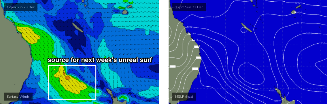
A trough is expected to strengthen in the north-eastern Tasman Sea on Sunday (in the wake of Saturday’s S’ly change) and this is expected to remain slow moving for a few days.
This system will be ideally aimed into Northern NSW, though slightly off-axis for SE Qld due to the coastal alignment (thus resulting in smaller surf) however the good news is that a strong ridge across the Qld coast on Sunday - resulting in our gusty winds - will relax through the early part of next week and by Xmas Day should see light variable winds across most coasts.
In fact Xmas Eve should see light winds south from about Ballina, with moderate SE winds winds throughout SE Qld (light SW early morning on the southern Gold Coast).
Wave heights are expected to build out of the SE thru’ E/SE through Monday, reaching a peak Tuesday and then holding into early Wednesday before easing throughout the day. Northern NSW should see solid 4-5ft+ sets at exposed spots at the height of the swell on Xmas Day (smaller surf running along the points) and SE Qld should see good (though inconsistent) 3ft+ surf at the outer points, with larger waves at exposed northern ends. Expect much smaller surf at the more sheltered points though.
So, it’s looking like a very festive time for waves in this next of the woods.
Long term shows our Xmas swell easing from Wednesday afternoon onwards, but a new ridge strengthening through the lower Coral Sea from Thursday onwards, rebuilding easterly trade swells into the end of next week and the following weekend. So, a typical summer pattern with persistent easterly swells for most coasts.
Have a great weekend, see you Monday!
Comments
Hi Ben, I live in Port Macquaire, are we in the fetch for the east swell? cheers
Yep!
I very much enjoyed those t'storms last night. Here's the boundary on approach to the Tweed.

Storms the last couple of nights have been extremely impressive.
NSW sure knows how to do a Southerly change.
From still , hot and sticky to bucketing rain , howling winds and degrees cooler in minutes.
Hats off , Huey.
Central Gold Coast foothills of Hinterland copped the 60km + winds
Our Power went off with Friday night black storm front @ 5:30pm
Whole area suffered hottest night with no Fans/Air-Con.
We were all still awake when doomsday struck at 2:30am.
I spoke to people coastwide who felt the biggest thunder roar in history.
Sure the lightning glowed whole night but that thud.
From the source here it comes.One could feel the ground vibrating thru the footings.
Then up the floor upstairs floor & walls rattling a 120kg bloke in bed. WTF!
Never in my life have i felt a Thunderbomb!
It owned the whole city from beneath the ground up & from top down!
Pressure bomb people are saying & it felt as if you were sandwiched between.
To be honest it resembled a sustained quake more than thunder but yet both.
All agreed it lasted minute/s...Got an eerie feeling it wasn't a one off. There'll be more!
Our power came back on this afternoon around 2:00pm.
Ravaged Neighbouring Towns are into 2nd night without power in stormy weather.
All punters claim wind swirled in cyclonic fashion. Zombie Owen's requiem?
Latest models have repositioned the developing trough/low in the NE Tasman Sea a little more to the south. This won't affect Northern NSW's surf potential, but may just pull back wave heights in SE Qld due to a more SE (than E/SE) swell direction.
pretty nice little pattern for xmas.
ben is the central coast getting solid waves next week
Geez, the WAMS from the 6th...