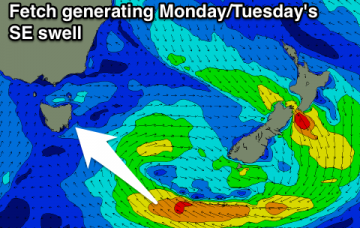
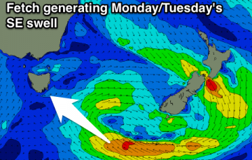
Freshening trade winds and building trade swells
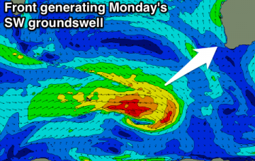
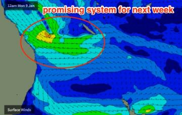
Model data has the S’ly change into the Gold Coast just after midnight tonight, reaching the Sunshine Coast around dawn.
Easing SE swell tomorrow with a morning offshore, tiny Wednesday with an inconsistent W/SW groundswell. New swell for later Friday with an onshore wind, clean and easing Saturday
Western Australia Surf Forecast by Craig Brokensha (issued Friday 30th December)
Sign up to Swellnet’s newsletter and receive the West Australian Forecaster Notes and latest news sent directly to your inbox. Upon signup you'll also enter the draw to win a surf trip to P-Pass for you and a mate. It doesn’t get much easier so click HERE to sign up now.
Best Days: Swell magnets in the South West Tuesday morning, Saturday morning, Sunday morning
Recap
Also arriving across the South Coast on Tuesday afternoon will be an unusual SE swell generated by a slow moving trough south of New Zealand over the weekend.
Onshore winds nearly all week until Friday, but with a small S/SE windswell. Clean and with a better swell for Saturday morning.
Poor tomorrow, with a new inconsistent SW groundswell Wednesday morning with improving conditions. Small and easing Thursday with another small fun swell Saturday morning with decent winds. Better potential next week.
Easing E/SE and NE swell over the weekend, with a good pulse of SE groundswell for later Monday, peaking Tuesday and easing slowly the rest of the week.
Tiny weekend, biggest Sunday, while a new SE swell is due to build Monday, hold Tuesday with a window of favourable conditions.
Inconsistent W/SW groundswell for tomorrow but with less than ideal winds, much better Sunday onwards as the swell eases. New SW swell for Monday.
Throughout Wednesday and into Thursday we’ll also start to see a building E’ly swell from the top of a broadening Tasman high.