Large swells inbound with clean conditions
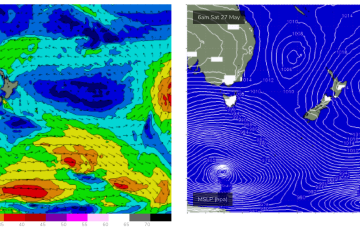
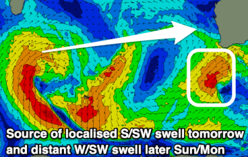
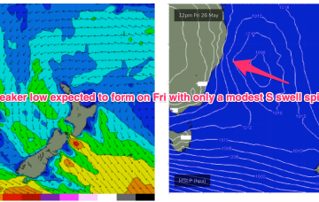
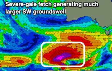
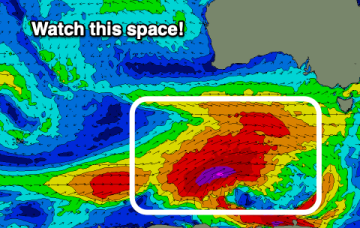
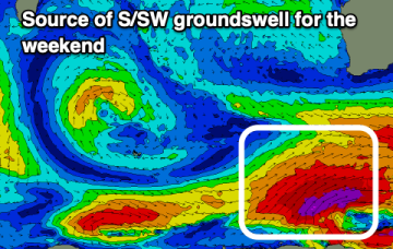
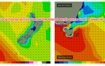
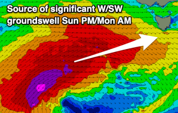
We've got a significant polar frontal progression on the cards this period with favourable winds as it builds, peaks and eases.
As we come to the end of Autumn we’ve got a typical looking winter synoptic pattern unfolding with a dominant high drifting over NSW bringing settled conditions with a very active Southern Ocean storm track spawning a strong cold front which will impact the state on Thurs. Most of the swell generating winds are better placed for Victoria with only small S swell wrap for NETas.
We've got cleaner conditions with a good sized S/SW swell tomorrow, easing into the weekend. A large S'ly groundswell will be met with tricky winds Sunday.
As we come to the end of another (very!) active Autumn we’ve got a typical looking winter synoptic pattern unfolding with a dominant high drifting over NSW bringing settled conditions with a very active Southern Ocean storm track spawning a strong cold front which will impact the state on Fri. The front and an upper low are expected to form a surface low Fri off the Central NSW Coast. Compared to Mon’s notes this low is now expected to be weaker and much faster moving bringing a smaller, faster up and down in S swell.
As we come to the end of another active Autumn we’ve got a typical looking winter synoptic pattern with a dominant high drifting over NSW bringing settled conditions with a very active Southern Ocean storm track spawning a strong cold front which will impact the state on Thurs. The front and an upper low are expected to form a surface low Fri off the Central NSW Coast. Compared to Mon’s notes this low is now expected to be weaker and much faster moving bringing a smaller, faster up and down in S swell.
The coming days don't look great, but from the weekend we've got much stronger swells inbound with good winds for the South Coast.
The surf will bottom out tomorrow ahead of building surf from Friday, becoming large and significant Sunday/Monday.
Clean conditions with moderate sized + swell pulses continue this period.
Poor surf over the coming days with onshore winds and small surf. A fun swell with improving conditions is due later week, possibly larger Sunday but with onshore winds.
In the short run and small, long period S swell trains are on the menu for Tues, generated by continuing frontal activity in the lower Tasman mostly aimed at New Zealand targets.