Good waves later week

Western Australia Surf Forecast by Craig Brokensha (issued Monday May 22nd)
Best Days: Thursday, Friday morning, Saturday morning in the South West
Features of the Forecast (tl;dr)
- Small, fading surf tomorrow with strengthening N/NE tending N/NW winds
- Small Wed with strong S/SW winds, W/SW tending S/SW-S/SE to the north
- Mod-large mid-period S/SW swell for Thu with E/SE winds
- Easing swell Fri with E/NE winds ahead of sea breezes
- Smaller Sat with E winds ahead of sea breezes
- Large S/SW groundswell Sun with W/NW winds
Recap
Very inconsistent but clean, fun waves when the sets came on Saturday, 4-5ft in the South West, 1-2ft across Mandurah and only 1ft in Perth. Yesterday was smaller and best across the South West magnets for the keen.
Today there's been a slight lift in new swell with inconsistent 4-5ft sets across the South West magnets with winds from the north-eastern quadrant, a bumpy 1-1.5ft across Mandurah and 1ft in Perth.

New swell this AM ahead of the wind
This week and weekend (May 23 - 28)
After a good run of swell and conditions the past few weeks, we're looking at a funkier run of surf this period, though there'll be decent windows later week.
The next two days are average with this morning's mid-period S/SW swell due to ease and early N/NE winds will strengthen and then shift N/NW later morning ahead of an approaching cold front.
This will create deteriorating conditions with no decent swell, poor Wednesday with strong S/SW winds in the South West, W/SW tending S/SW across the metro locations, possibly shifting S/SE for a period but then back to the S/SW.

The frontal system linked to the coming winds will produce a fetch of strong SW winds while projecting up through our southern swell window.
This will generate a moderate-large mid-period S/SW swell for Thursday, peaking through the day in the 6-8ft range across the South West, 2ft to occasionally 3ft in Mandurah and 2ft across Perth.
Winds will improve rapidly thanks to the front pushing east on Thursday, bringing E/SE offshore winds to all locations that look to persist all day.
Friday looks great as well with a lighter, morning E/NE breeze before a trough brings a shallow S/SW change. With the easing swell, get in early.
Later in the week a significant polar frontal progression developing late in our swell window, to our south-southwest looks to produce a large S/SW groundswell for Sunday.
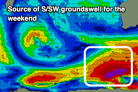
An initial fetch of pre-frontal W/NW gales will setup an active sea state for a stronger fetch of severe-gale to storm-force SW winds to move over, but the developments are a little late in our swell window to be ideal.
We should still see 8ft+ of S/SW groundswell across the magnets in the South West as the swell peaks Sunday, with 2ft waves in Mandurah and Perth, though slow. Unfortunately W'ly winds look to spoil this swell on Sunday but the models diverge a little so there's room for some possible improvement. Check back on Wednesday for a clearer idea what's due on Sunday and into early next week, which looks to be persistent NW winds.