Make the most of the coming windows of waves
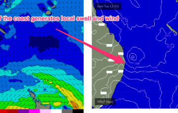
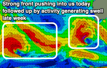
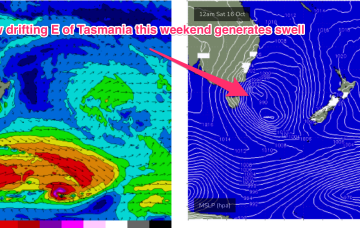
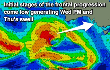
There's a few fun windows of waves in between bouts of onshore winds. Get stuck in as mid-late next week looks slow.
High pressure drifts across the Tasman from a position in Tasmanian latitudes this week. An approaching mid-latitude low in the Bight tightens the the pressure gradient along the western flank of the high in the Tasman, with an increase in N to NE winds off NSW coast through Wed. It’s Thursday and Friday that really muscle up with gales aimed directly at NETas.
The coming week will be small to tiny size wise ahead of a stormy S/SE swell this weekend.
A front is bringing another vigorous S’ly change through on Mon and a trough, just in advance of the front is now moving northwards, with a small low pressure system expected to form off the North Coast, near the QLD border overnight or early tomorrow.
Plenty of swell and with initially poor conditions across the South West, improving later week.
The second half of the week looks a little more interesting. An approaching mid-latitude low in the Bight tightens the the pressure gradient along the western flank of the high in the Tasman, with an increase in N to NE winds off NSW coast.
Get stuck into the exposed beaches tomorrow ahead of some new, windy and sizey westerly swell through the middle to end of the week. There'll also be a bout of cold, wet weather.
It'll be mostly favourable for the beaches over the coming period with the local wind regime and incoming swells. The weekend will be generally poor, good early-mid next week.
The storm track isn't favourable at all for our region. Try the East Coast Forecaster Notes.
A much more solid swell event then unfolds through the second half of next week , with a high pressure system drifting in the lower Tasman towards the South Island and a strong N’ly fetch developing off the back of the high, with pressure gradients being tightened by an approaching mid-latitude low in the Bight.