A couple more fun days for the beaches, poor in between

Victorian Surf Forecast by Craig Brokensha (issued Monday 11th October)
Best Days: Tomorrow on the beaches, Thursday morning, possibly Sunday morning for the keen on the Surf Coast, early-mid next week on the beaches
Features of the Forecast (tl;dr)
- Easing mix of swells tomorrow with E/NE tending N/NE winds ahead of late afternoon SE breezes
- Low point in swell Wed with strong NE winds, possibly tending N/NW late
- Inconsistent but fun W/SW groundswell Thu with local offshore winds and afternoon sea breezes
- Easing W/SW swell Fri with strengthening W/NW tending strong SW winds
- Stormy conditions Sat with a mix of windswell and new SW groundswell under strong SW-S/SW winds
- Easing mix of swells Sun with weaker SW winds (likely W/NW early on the Surf Coast), smaller Mon with N/NE winds
- Fun SW groundswell Tue with N/NE winds
Recap
Friday's great waves especially on the beaches into the afternoon with a new W/SW swell, held better than expected into Saturday with clean conditions and 2-3ft sets on the Surf Coast, 4ft+ to the east with favourable winds for most of the day again.
Our new mix of swells for yesterday, that being an infrequent W/SW groundswell and mid-period energy showed from early with better 3ft sets on the Surf Coast, 4-6ft to the east but with less than ideal conditions that deteriorated through the day. The Surf Coast offered early W'ly winds and lumpy conditions before a stronger SW'ly kicked in.
This morning conditions are still poor with onshore winds and surf to 2-3ft on the Surf Coast and 4-5ft to the east.
This week and weekend (Oct 12 - 17)
The coming week will be generally best suited to the beaches with fun sized swells and favourable winds ahead of a strong cold outbreak into the weekend.
Yesterday's pulses of W/SW swells are now easing across the state and will continue to do so tomorrow as winds improve for the beaches, remaining favourable until late afternoon. The groundswell component was generated by a strong/patchy polar low mid-last week in the Heard Island region, while the mid-period energy from the remnants of the storm as it moved under the country, through the Bight.
This activity cleared through the weekend and we'll see the Surf Coast easing back from a small 2ft on the sets across the swell magnets, and 3ft+ to the east. Dawn won't be ideal with a light to moderate E/NE breeze, shifting N/NE through the morning and holding ahead of late afternoon/evening SE breezes.
Winds will strengthen into Wednesday from the NE as a slow moving mid-latitude low starts to push in from the Bight, squeezing a high in the Tasman Sea. There'll be no real size or swell left in the tank with tiny options on the Surf Coast and possibly the odd stray 1-2ft set on the Mornington Peninsula.
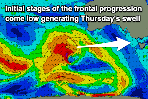 Our new, inconsistent W/SW groundswell for Thursday is on track, generated by the earlier stages of the mid-latitude low that will form in the Bight tomorrow evening. This is a great fetch of W/SW gales that have been and are still being projected up towards Western Australia, through our western swell window, before pushing too far north and out of our swell window.
The swell will be inconsistent and west in nature but should come in around 3ft on the Surf Coast and 4-6ft to the east, holding all day.
With the mid-latitude low stalling slightly in the Bight and to our west we'll see favourable local offshore winds Thursday, light to moderate N/NW on the Surf Coast and N/NE-N on the Mornington Peninsula ahead of afternoon sea breezes but without too much strength.
The low will finally start to move in on Friday, bringing strengthening W/NW winds as the W/SW groundswell eases, giving into an afternoon and vigorous SW change.
 The low is forecast to strengthen off the East Coast of Tasmania into the evening, bringing strong SW-S/SW winds and a moderate sized S/SW windswell through Saturday, easing slowly Sunday as winds abate fairly rapidly.
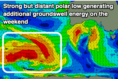
There'll also be a moderate sized, inconsistent SW groundswell in the mix Saturday, easing Sunday, generated by a strong low firing up east of the Heard Island region over the coming days. This looks to produce 3-4ft of groundswell for the Surf Coast and 6ft waves to the east, underneath the local windswell.
Sunday will see those abating winds and mix of swells easing with the possibility of early W/NW breezes on the Surf Coast, but we'll review this Wednesday.
Longer term winds will revert back to the N/NE early next week and we've got a fun SW groundswell on the cards for Tuesday, but check back here on Wednesday for more regarding this.
Comments
Can you make summer happen? Please?
With La Nina forecasted again might get a summer in 2023?
Still a bit wobbly but cleaning up on the beaches..
hi CB are you able to send an updated link for lwt. the one i use below has not been opening the maps for the last 6months or so.
https://www.weatherzone.com.au/models/?lt=hemisphere&lc=sh
thanks in advanced PIGDOG
Yeah we're in the same boat unfortunately. They (NOAA) took out the variable that we used to create the charts from the model output and don't seem to be keen on adding it back in. Real unfortunate. There are other ways you can gather the data but it's nothing like the charts we had which were super easy to read and decipher.
No problem thanks for the update and quick response :)