A fun week of waves working the winds

Western Australia Surf Forecast by Craig Brokensha (issued Monday October 11th)
Best Days: Protected spots tomorrow in the South West, Perth and Mandurah through the morning, Wednesday morning, Thursday morning, Friday
Features of the Forecast (tl;dr)
- Large SW groundswell filling in tomorrow with strong S/SW winds (SE through the AM in Perth and Mandurah)
- Easing SW groundswell Wed with morning S/SE-SE winds (SE in Perth and Mandurah through the AM)
- Building SW groundswell Thu PM with moderate E/SE tending SW winds
- Good SW groundswell for Fri with fresh E tending variable winds
- Easing SW groundswell Sat with strong S/SE tending SW winds
Recap
Saturday saw a good pulse of new SW groundswell with favourable winds for protected spots in the South West, peaky and cleaner to the north with 2-3ft waves in Mandurah and 2ft+ waves across Perth.
Yesterday was much cleaner and better in the South West with a drop in swell back to 4-5ft, 2ft in Mandurah and 1-2ft across Perth.
Today the swell is a touch smaller again and with onshore winds kicking back in across the South West, more variable further north but still bumpy and only for the desperate.
This week and weekend (Oct 12 - 17)
The shift in winds back onshore and strengthening through today is linked to a strong frontal system pushing up and across us, bringing a large SW groundswell behind it tomorrow.
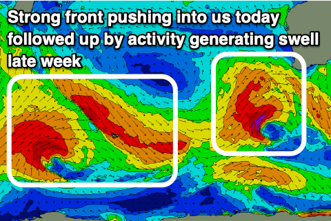 This front formed around the Heard Island region on the weekend, with a great fetch of SW gales being projected through our swell window, with stronger bursts of severe-gales seen at stages.
The swell is due to fill in tomorrow and peak through the day to 10ft to occasionally 12ft on the South West magnets, 4ft across Mandurah on the sets and 3ft or so in Perth.
Winds are still due to be poor across the South West and best in protected spots as the frontal system stalls slightly through tomorrow while forming into a mid-latitude low in the Bight through the evening.
This will see strong S/SW winds, swinging S/SE on dark, with SE breezes in Perth and Mandurah through the morning.
Wednesday should see better though not ideal S/SE-SE winds across the South West through the morning SE further north as the large swell eases back from the 8ft range on the sets, 3ft across Mandurah and 2-3ft in Perth.
Thursday will finally clean up across the exposed breaks with a moderate E/NE offshore but smaller, weaker swell easing from the 4ft range in the South West, small to tiny to the north.
Into the afternoon Thursday, a new, moderate-large sized SW groundswell should arrive, holding Friday morning. This will be generated by a polar low forming west of the Heard Island region last night, generating pre-frontal W/NW gales followed by a longer-lived fetch of W/SW gales, breaking down south-west of us on Wednesday.
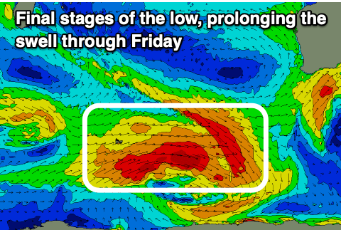 The swell looks fun in size, providing good surf in the 6ft+ range across the South West, 2ft+ in Mandurah and 2ft across Perth on the sets Thursday afternoon and Friday morning. Winds look great Friday morning and fresh from the E, variable into the afternoon, while as the swell eases Saturday a trough/low forming off our coast is hard to resolve by the models. We're likely to see strong S/SE winds.
Unfortunately Sunday will see onshore winds, with the models in alignment regarding this, and the swell will be on the ease.
Another approaching frontal progression through early next week should bring a moderate to large W/SW groundswell for mid-late week but with onshore winds. More on this in the coming updates.
Comments
The endless winter!! Brrrr
Yep!! haha. How's today!!! Bloody hell!!