Extended period of northerly winds and poor surf; next window Tues/Wed from the south

South-east Queensland and Northern NSW Surf Forecast by Ben Matson (issued Wednesday 9th October)
Best Days: Thurs: small N'ly windswell with winds veering NW. Keep your expectations low. Tues/Wed: strong S'ly swell.
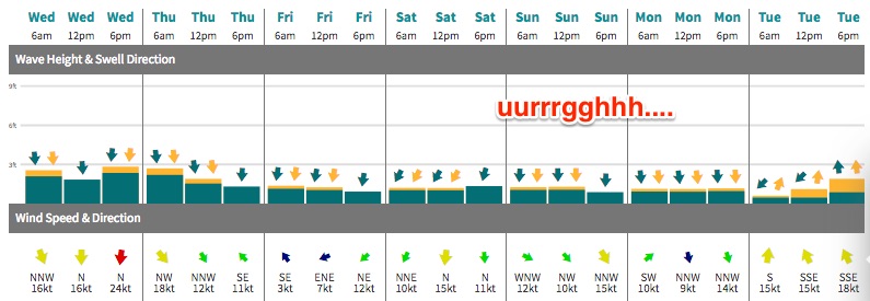
Recap: Northerly winds have made a meal of the surf over the last few days. Easing southerly swells on Tuesday have been supplemented by low quality N’ly windswells.
This week (Nov 10th - 11th)
There's not a lot of love on the way for the next few days.
The stationary trough off the Mid North Coast will retreat slowly east on Thursday, easing the synoptic gradient and swinging winds around to the north-west across SE Qld and Northern NSW, with light westerlies across the Mid North Coast.
Today’s northerly fetch doesn’t look quite as consolidated as previously modelled but there’s still a chance for exposed north facing swell magnets to pick up a few 2ft to maybe 2-3ft sets on Thursday morning, before easing during the day.
There’s no real south swell expected over the coming days either; the southern flank of the trough may generate a minor short range SE swell but it’s aimed mainly into Southern NSW (where sets won’t reach much more than 2ft+ there anyway). So the Mid North Coast may see a few small waves early morning but it’s not worth working around.
All of these swell sources will then ease further into Friday with early light winds tending NE during the day and freshening.
This weekend (Nov 12th - 13th)
There’s more northerly pain for Saturday, with very little swell prospects on hand - just local windswell at best as winds ratchet up to fresh to strong strength.
Winds will swing W/NW on Sunday as a new trough crosses the coast, associated with a broad low pressure system across the SE corner of the country. However, we’re still looking at tiny surf, with no new groundswell expected thanks to a benign synoptic pattern across our swell window(s) during the previous days. There should be some small leftover NE windswell across exposed beaches but I’m not confident of any major quality.
There is one other possible small source of swell for the weekend - a minor mid-range S’ly swell, originating from a broad but ultimately modest SW fetch locations south of Tasmania from late tonight through Thursday and Friday.
As per Monday's notes, ordinarily I’d discount this as a reliable source but the fetch size is quite impressive (despite the low wind speeds) and it could provide a useful undercurrent of S’ly swell in the 2ft range through Sunday, though sets will be very inconsistent and only reliable south swell magnets south of Byron Bay will pick up any rideable energy.
Next week (Nov 14th onwards)
The broadscale low pushing across the SE corner of the country this weekend is very complex and there’s a couple of swell sources for next week to keep tabs on over the coming days.
First up, the southern flank looks quite dynamic with a strong easterly infeed expected to generate solid NE tending E’ly swells for Tasmania’s East Coast. Model guidance has this fetch aimed well south of Southern NSW (let alone the Northern NSW), so there's little to no swell potential for us right now - but it’ll be worth keeping an eye to see if it changes over the coming days, as we’ve already seen some major revisions in the synoptics since Monday’s notes were issued.
Otherwise, it looks like the western flank of this broad system will enter the western Tasman Sea later Monday, with a strong building trend out of the south expected throughout Tuesday, peaking into Wednesday morning that should reach 4-5ft at south facing beaches south of Byron Bay - albeit with fresh winds out of the southern quadrant at times. I'm not expecting very much size across SE Qld away from the region's south swell magnets.
Wednesday morning currently looks the pick with winds likely to be W/SW for a brief period early in some locations. Easing swells are then expected for the second half of next week.
More on this in Friday’s update!
Comments
"Winds veering NW" Opening a can of worms there!! I assume You mean from the N?
Glad I made the effort today, few small but fun ones around. Satisfaction earned from lowering expectations...
Outside chance of some early wet season signs in a week or so.
Hopefully that blob between us and New Cal next Sunday marks the start of something.