Solid S'ly swell for northern NSW magnets

South East Queensland and Northern New South Wales Surf Forecast by Guy Dixon (issued Wednesday 25th May)
Best Days: Thursday and Friday
Recap:
Mid-range southerly swell has been providing good, fun options across the south facing beaches of northern NSW over the past couple of days, building to around 3-5ft today. Winds have remained easily workable each day under a light offshore breeze, becoming light/variable onshore each afternoon.
Southeast QLD hasn’t fared so well. Virtually none of this energy managed to push north of the border, with peaks in the 1ft range yesterday, just over 1ft today.
This week (Thursday 26th - Friday 27th):
Parts of the Sydney and Illawarra coasts have been graced with solid sets well over 6ft today, with some offshore bombies providing heavy sets in the 10-12ft range.
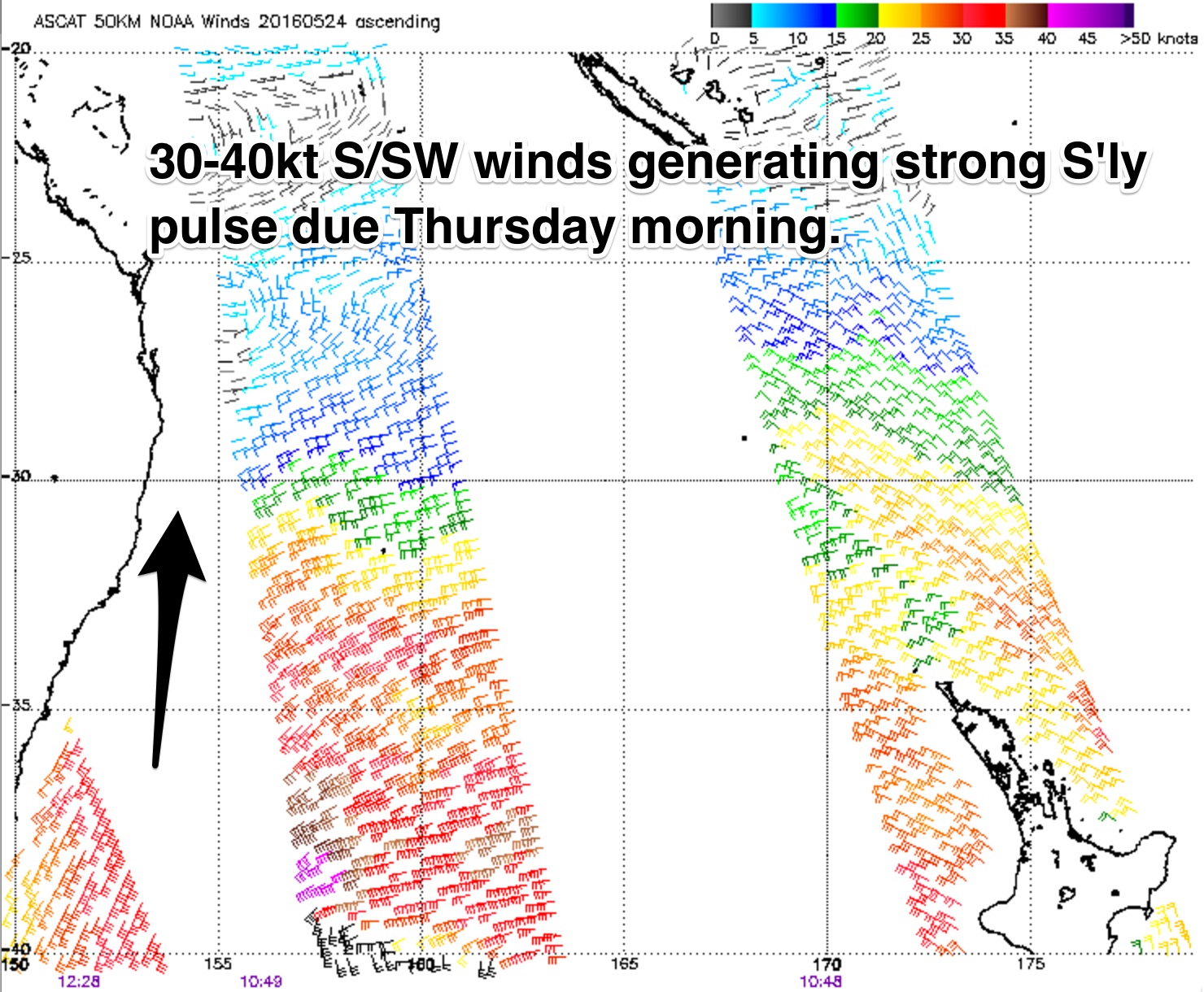 This swell is currently moving up the Mid North Coast and will continue northward overnight and into the early hours of tomorrow morning.
South facing beaches along the northern NSW coastline can look forward to sets in the 6ft range on Thursday morning, with exposed swell magnets and bombies once again offering stronger sets. Beaches not directly open to the south will however be smaller in size.
Due to the acute southerly swell direction, many locations across southeast QLD will also miss out, with only the more exposed spots picking up small amounts of energy. The outer points along the Gold Coast may see sets in the 2ft to occasionally 3ft range, but for the most part, the action will be confined to exposed beaches open to the south.
Conditions are likely to be clean at most spots on Thursday morning, with a northwesterly breeze across northern NSW and southeast QLD, more light/variable along the Mid North Coast. The points of southern QLD are likely to deteriorate in the afternoon as winds swing northerly, less so at south facing beaches south of the border. Locations south of about Coffs should remain clean into the afternoon.
This swell will fade after Thursday morning’s peak, further throughout Friday from the 3-4ft range, occasionally bigger as the odd strangler set fills in across south swell magnets. Obviously, being further south, the Mid North Coast will see it’s peak late this afternoon (perhaps even overnight), before entering an easing trend by Thursday.
A westerly component airflow will dominate on Friday, leading to clean conditions at most spots, persisting well into the afternoon.
This weekend (Saturday 28th - Sunday 29th):
The next significant swell generating system should develop on Thursday night in the form of a small, cut-off low just off the far South Coast of NSW, near Eden. The western flank of this low looks to steer south/southwesterly fetches of 35-45kts up the coast, driving further offshore throughout Friday.
This small but intense and close range system should whip up a mid-range southerly swell for exposed south facing beaches due on Saturday morning across the Mid North Coast. South facing beaches will see most of the action once again, with sets in the 3ft range. Less exposed beaches are likely to be significantly smaller due to the swell direction and modest swell periods.
Back beaches of northern NSW should pick up this energy from late morning and early afternoon to a similar size.
Conditions are likely to remain clean once again under a light westerly breeze, increasing into the afternoon on Saturday. Sunday should see a similar set up, with a persistent west/southwesterly breeze.
Southeast QLD will likely dip out once again, with this system lacking the energy and alignment necessary for decent swell. In fact, southeast QLD has limited prospects in the near future, with only small, weak, fleeting systems on the forecast.
In Monday’s notes we were monitoring a small fetch which was expected to anchor itself off Stewart Island, the far southern tip of New Zealand, but models have moved away from this idea.
The only other system of interest comes in the form of a gusty, local southerly component airflow moving up the NSW coast. Southwesterly breezes look to tend more south/southwesterly and increase for a brief period of time on Sunday night before pushing offshore.
The resultant swell only looks modest, with around 2ft of weak windswell breaking across the exposed back beaches of the NSW coast on Sunday, not much else.
Background energy generated by poorly aligned and poorly structured fetches should otherwise maintain small peaks across south facing beaches in the days following, ebbing and pulsing around the 2ft mark, smaller at less exposed spots.
Comments
Sweeeeeet
Not so sweet for SE Qld
Is that I'm in Miami Bit$h Bretto , As per forecast, it aint that far to get uncrowded s swell Beachies,points,reefs, Early tomozza
TOS will be pumping.
Burleigh too.
Bingo
Haha, used to live in Miami. Thanks for the motivation Simo, time to do some early morning missions.
not much interesting on the buoy data....seems about the same or slightly less energy than yesterday.
will go see what my eyes show me.
And the northerlies are blowing pretty strong
it's caca
and the sunny coast wins out over northern nsw for once
get a few up there mcsc?
What drugs were they on?
http://www.sunshinecoastdaily.com.au/news/safety-warning-as-big-swell-he...
By sunny hoax standard's, yes. Low tide early and nw offshores = fun morning :-)
Saw that BOM issued a crazy surf warning. Think they over-call lots now after copping a thrashing over the Sydney to Hobart race years back
Went to the Goldie nth end early....back home for a pull in 10 mins. No swell
That was a substantial over call on the forecast for today
Devil wind to boot !
Parts of Sunny Coast had strong lines this morning. Bigger sets easily overhead. Long and straight though, banks not shapely enough where I was.
interesting to hindcast this swell and compare it to forecast.
It came on about 6hrs ahead of schedule Tues (ie was in the water lunchtime far NENSW), had a peak yesterday and waned more quickly than expected today.....
Looks like Sunny coast fared OK as some of yesterdays pulse made it around the Cape.
we never really got the size today ......which was expected considering what happened on the Illawarra yesterday.
Question for the experienced posters on here....
What's the feeling on posting photos of the surf, if landmarks and names aren't mentioned? I'm don't want to 'advertise' spots (eg I wouldn't post pics of defined points / reefs) but I also find it interesting to see from others what the surf was like / size at different general locations. Thoughts welcome before I post anything! Thanks.
Benno if you want shapely you've gotta start thinking of Gary.
Maybe I don't want shapely anymore! No offence Gary.
benno, I think you answered your own question.
Cheers freeride. This was an average set this morning...

to me, that looks like the typical remnants of a S'ly groundswell on the Sunny coast.
very straight and very long. basically close-outs.
Was it that, or better than it looks?
Swell was mostly straight and inconsistent Freeride, head high with occasional overhead. Case of finding the right sandbank and its was a tonne of fun
I didn't hunt around for a better bank, so yeah, mostly closeouts with the odd one that would run a bit.
Next week looks worse, the beginning anyway. Thought I'd try and scrape something so went to a northern corner to find a waist high peak......looked like there was the odd one coming through but with 10 guys on it already and another 6 getting ready to go out decided on beer instead. After such a good start to the year it has certainly ground to a halt..
Seen some footage from Straddie this morning, clean shoulder/head high barrels - looked fun.
These bloody northerlies though - feels like Spring!
ohh yeah,
Fun stuff, for sure;)
Bathymetry ?
Was no good anywhere south of the cape from day break. Don't know if it changed at all during the day as I stayed away.
nah it went from bad to totally shithouse.
I can't see tomorrow being much better either.....any westerly is going to take 5-6hrs to clean up the northerly leftover scarring.
Guy got both the headline wrong and the content of the forecast.
It was small (2ft/2ft+ mostly but the odd set clsoe to 3ft) and clean and A framey on this one bank that I saw this morning Steve. Didn't look to have too much (if any) northly scarring on it where I was. Probably due to the fact that when I went for a walk along the beach last night at around 10pm, there was no N'ly wind. If anything it had already swung SW due to the passage off the earlier scattered storms.
there was no northerly scarring because all there was left was a small leftover NE windswell.
Not where I surfed.
what coast?
there wasn't a trace of S swell left in the water here.
It was a pure NE windswell.
Can't imagine it being any different in SEQLD.
Poor Guy.
Took the dog along TOS this arvo m, pretty small 2ft max but clean
Those Northerlies moved a fair bit of sand around last night.
Yeah I noticed that as well
Cant hurt
Been a tough week for Guy.. Thursday's south swell was super tricky to call given Southern NSW's over-delivery on Wednesday. And today we've seen a somewhat unexpected NE windswell kick up from last night's N/NW fetch off the coast.
Just checked the beachies across the road from the office, and they're shoulder high + and super fun, clean as a whistle too.
This is about as optimistic as the models got on this fetch too (on Thursday's run). Almost all aimed offshore.
But as we can see, ASCAT recorded a little more north in the direction than the models were predicting, much closer to the coast too. Doesn't take much to swing an unfavourable fetch into a favourable one.
Even the BOM's 10am update for Gold Coast Waters - that had the benefit of coastal observations, and local buoy data showing a NE swell - still only forecast a "1m southerly swell" for today. Seems to have caught them by surprise too.
Not normally one to nit pick on forecasts am only commenting because I had changed my week around to chase waves on Thursday - shoulda gone wednesday
Best Days: Thursday and Friday
was a big miss
Better luck next time Guy.
Yep, Wed was super fun. Found an epic sand slug. Shame a man in a grey suit showed up as we were warming up on the sand at dawn. We still went in as the man in the grey suit was heading down to the lone surfer further north of us (well at least that's what we told ourselves as we paddled out).
Yeah Guy got thrown in the deep end this week - Craig's on leave (back on Monday), and my schedule has been manic, so I haven't been able to assist much - it's always hard to pick up a forecast region on the fly that you haven't spent a lot of time in.
Guy has been doing our Sydney and WA forecasts for a while now, and doing a great job too - but SE Qld/NNSW is a completely different ball game.
Was that you on the TV last night Ben?
No, unless it was a hidden camera!
That Guy is a great Guy.
Leave him alone.
He's doing a fine job.
Thanks Guy. ;)
You're a real type of a guy's Guy.
Lucky you weren't called Bruce!
Found a low tide bank all to myself this arvo. NE swell and howling SW wind, had to wait for the waist high bombs but good fun!