Good S'ly pulse on track for the weekend

South East Queensland and Northern New South Wales Surf Forecast by Guy Dixon (issued Wednesday 18th May)
Best Days: Saturday morning and Wednesday morning.
Recap:
Small conditions have continued over the past few days, with only the exposed south facing beaches of Northern NSW picking up any decent size. Southerly swell has been providing clean little peaks in the 2ft range, becoming tiny north of the border.
Conditions have been clean each morning under a light/variable offshore breezes, becoming bumpy with the development of a northerly breeze tending onshore late each morning.
This week (Thursday 19th - Friday 20th) and this weekend (Saturday 21st - Sunday 22nd):
The remainder of the week is looking fairly quiet, with only one small weak swell source which is migrating up the NSW coast as we speak. The Sydney and Hunter coast saw a small lift in energy this morning, with sets in the 2ft range.
This swell front will continue pushing northward this afternoon, maintaining workable little options in the 2ft range across the south facing beaches of Northern NSW. Thursday morning should see small, weak leftover fading from the 1-2ft range at back beaches.
Southeast QLD isn’t likely to see any love with this small pulse, primarily due to it’s small, weak nature and southerly direction. For residents of the Sunshine State, head south of the border to gain more exposure to the south for more size.
Otherwise, conditions will remain tiny, with little more than 1ft breaking on Friday.
A weak south/southwesterly breeze looks to be established from first thing south of about Coffs Harbour on Thursday, tending more west/northwesterly further north. As the day wears on, conditions should deteriorate as breeze tend light southeasterly. A similar set up is likely on Friday, with south/southwesterly breezes slowly swinging south/southeasterly as the day progresses, bringing an impact on wave quality.
Better prospects for surf come late on Friday (for the Mid North Coast) more so Saturday further north, generated by a strong front and low which is due to move into our southern swell window into Thursday.
Firstly, poorly aligned west/northwesterly fetches look to exit Bass Strait on Thursday, whipping up an initial pulse which is due across the Mid North Coast late on Friday afternoon. However, this first pulse is somewhat insignificant in comparison to the better energy which is due to follow soon after.
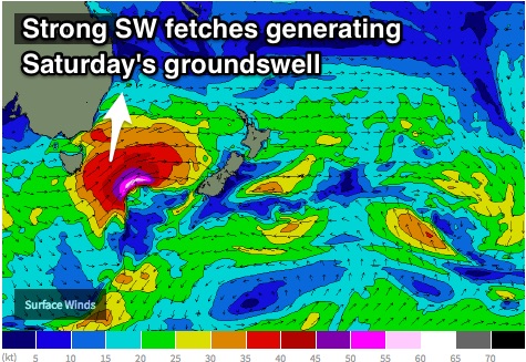 These west/northwesterly fetches over eastern parts of Bass Strait should tend more west/southwesterly with core winds of 40-45kts on Thursday afternoon, followed by better southwesterly fetches with the core of the low southeast of Tasmania. We have been monitoring the movement of this system over the past few model runs, which have been suggesting an eastward motion (even slightly east/southeastward at times), stalling briefly over the central/southern Tasman, before moving northeast once again up the guts of the Tasman towards New Zealand.
More recently, this stalling motion has been downplayed and delayed slightly. It looks as though the best time for swell generation will be a touch too late in our swell window, with the southwesterly 45-55kt core winds lacking the ideal alignment.
Nevertheless, the storm track of this system is leagues above the recent zonal activity we have been enduring, so we can still expect a promising start to the weekend, with southerly swell building across the exposed south facing beaches of Northern NSW to around 4-5ft on Saturday (morning for the Mid North Coast, later further north).
As for the coast of southeast QLD, size will be significantly less due to the swell direction, however selected south swell magnets across the region may be offering sets in the 2ft+ range by Saturday afternoon. Most Gold Coast and Sunshine Coast beaches will remain tiny due to the unfavourable swell direction.
Weaker, broader southwesterly trailing fetches following this system up through the Tasman should maintain a small amount of energy for Sunday, more likely slowing the easing trend rather than providing more size. Back beaches of Northern NSW should ease slowly from the 3-5ft range on Sunday, smaller at less exposed breaks.
The early morning should offer the cleanest options on Saturday under a southwesterly airflow, with wave quality dropping as breezes swing southeasterly into the afternoon. Similarly, Sunday is looking at a light westerly breeze across Northern NSW, more northwesterly for the Mid North Coast, tending onshore in the afternoon.
Next week (Monday 23rd onward):
Monday is likely to be in between swells, with only small leftover energy breaking across the magnets. Not to worry fresh swell isn’t far away.
The next most significant system looks to enter our southern swell window on Monday in the form of a strong front and low.
Similarly to the last system, west/southwesterly fetches are likely to lead the way, exiting Bass Strait in the afternoon and moving up the NSW coast, with more distant, stronger southwesterly fetches pushing up through the Tasman overnight and into Tuesday.
The core fetches don’t look as strong, just 35-45kts, but are elongated and moving in a slingshotting motion, despite a less than ideal alignment.
Two pulses are on the cards from this system, initially mid-range energy off the leading fetches pushing up the Mid North Coast on Tuesday afternoon, followed by stronger energy peaking on Wednesday morning with sets breaking across the exposed swell magnets of Northern NSW in the 3-5ft range.
Similar to the last pulse, locations north of the border are likely to miss out on the majority of the size, picking up just 2ft on the sets at the handful of exposed spots across the region.
A gusty south/southwesterly breeze will be hugging the coast line on Tuesday, making it tricky to find a decent wave that’s not wind affected. The early morning holds the best chance with breeze expected to tend more west/southwesterly.
Lighter winds are on the cards on Wednesday, just in time for the peak in swell with clean conditions during the morning, deteriorating throughout the afternoon as a seabreeze develops.
More detail in Friday's notes.