Lots of complex south swell ahead for Northern NSW; expect disappointment in SE Qld

South East Queensland and Northern New South Wales Surf Forecast by Ben Matson (issued Wednesday 11th May)
Best Days: Strong series of south swells building Thurs/Fri/Sat/Sun. Lots of size south of Byron but not much size in SE Qld due to the direction. More south swell next week too!
Recap: Our most recent prolonged east swell eased very slowly through Tuesday, ahead of a more pronounced easing trend today. Most open beaches still managed 2-3ft sets throughout Tuesday, with winds holding from the NW at many coasts (N’ly in a few locations). This morning, surf size dropped back to 1-2ft at most open beaches (smaller into the afternoon too), and conditions were sparkling clean under a brisk W/SW wind. A new S’ly swell pushed up along the Northern NSW coast today, well ahead of schedule - this actually originated from the gale force W/SW fetch behind the front, of which the swell correspondingly spread back into the coast, north of an axis point that appeared to be around the Hunter/Coffs region (as Sydney beaches were tiny). These swells are super tricky to have confidence in as the responsible fetch was almost perpendicular to the coast - aimed towards New Zealand! Sets seemed to be around the 3ft mark at south facing beaches south of Byron.
This week (May 12th - 13th)
No changes to the forecast for the rest of the week.
We have a series of south swells on the way, originating from several unusual parts of our acute south swell window, and each will deliver a wide range in size and energy across the coast, depending on your region’s exposure to the south.
Normally I’m reluctant to offer overly-broad estimates in likely size ranges, but this is very likely what’s going to pan out over the coming days. Some reliable south swell magnets will pick up exponentially more swell than everywhere else, and sheltered corners will remain tiny due to the swell direction. Therefore, creating a one-size-fits-all forecast is near impossible.
The swell sources are very interesting too. We’ve got a vigorous frontal progression south of the continent with westerly gales sweeping Tasmania and the southern mainland coasts. The overall progression is very "zonal” in alignment, meaning it’s very west-east aligned, which ordinarily is not favourable for East Coast swell generation. But the passage of multiple systems allows a very active sea state to build up, and each front usually has a couple of features that swings the swell potential in our favour - initially a overall south of west fetch direction, and then also a small region around each primary low where core winds are aimed more meridional (north - south).
So the end result is an extended run of small to moderate south swell for our region (which only favours exposed south facing beaches), interspersed with several pulses of solid, long period south swell. These peaks are what we need to pin down as they’re likely to max out the open beaches, but more importantly will provide good mid-sized waves at remaining beaches and even some small peelers inside southern corners.
And hopefully a few small waves across SE Qld too (which will otherwise completely dip out from this southerly progression).
So, I'm expecting two or three individual pulses of south swell through Thursday and Friday. I’m still finding it difficult to pin down precise times, because the nature of these overlapping events means that we’ll see staggered arrivals as the energy pushes along the Mid North Coast and then the Northern Rivers (and lastly the outer fringes of SE Qld).
But for what it’s worth, it’s probably worth noting these points:
- Although Thursday should see a steady upwards trend all day, the Far North Coast (north of Yamba) may be rather undersized early morning, compared to southern regions.
- Friday will probably see the largest waves of the period - if anything, before lunch across the Mid North Coast, and after lunch across the Far North Coast.
- I’m skeptical that the broader SE Qld coast will see much surf during this period, due to the direction
As for size in Northern NSW, later Thursday and Friday have the potential to see 5-6ft+ sets at the height of the swell, but only at reliable, well exposed south swell magnets. Remaining open beaches should see a peak in the 3-4ft+ range, and protected southern ends will be much smaller again.
Across SE Qld, Friday will likely see the biggest surf but it probably won’t reach much more than an inconsistent 1-2ft at most beaches (expect smaller surf on Thursday). The region’s handful of south swell magnets should however see some decent waves, maybe 2-3ft later Thursday and then 3ft+ at times through Friday (probably the afternoon). But, confidence is only low for this to eventuate.
Winds will remain light offshore for most of both days, so there’s no need to work around an early period of light winds.
Let’s wait and see what happens!
This weekend (May 14th - 15th)
The weekend has more of the same on the cards for the entire region.
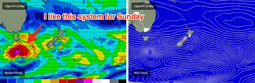
Model guidance is winding back wave heights quite a bit from Friday's peak, but I don’t think it’ll be quite as drastic as it's suggesting. Two more southerly long period groundswells are due to push through over the weekend - one on Saturday, another on Sunday - but they will be slightly less favourably aimed within our swell window. So this does reduce the surf size potential but I think the models are going a little overboard.
If anything, I like Sunday’s swell more than Saturday’s, mainly due to the core wind strength and alignment from the responsible low as it tracks south of Tasmania on Friday. But this will probably create an even wider range in wave heights across the region.
So, for now I’m going to keep the outlook broad for the weekend, and I’ll refine the data on Friday with the availability of the latest model guidance and satellite winds. Exposed south facing beaches in Northern NSW (south of Byron) should see 3-5ft sets both days (actually, I wouldn't be surprised if there are bigger bombs at times on Sunday), but most open beaches will be much, much smaller aorund 2-3ft, and it'll be tiny surf inside southern corners.
North of the border, it looks like both days will remain tiny at most open beaches (~1ft or so) however south swell magnets could pick up occasional 2ft+ sets.
Winds look light and variable for the most part too - perhaps a minor northerly freshening trend into Saturday, but mainly south of Yamba (probably won’t affect the surf too much).
Let’s fine tune this outlook on Friday.
Next week (May 16th onwards)
Would you believe - the strong Southern Ocean storm track is expected to persist right through into next week.
So, at this stage it looks like South-east Queensland will continue to see tiny surf conditions right through until the end of next week, possibly even next weekend, whilst Northern NSW will see a string of solid back-to-back southerly groundswells.
More on this in Friday's updated notes.
Comments
Righto. Time to make some popcorn and see what happens.
Just to pull the focus out further: so much for a transition to La Nina; these frontal progressions and zonal fetches leading to episodic south swell pulses look very El Nino to me.
No Freeride , it's a classic pre switch setup .
Look back through the years of big swells around the world ( especially with solid periods attached to large wave heights ) there's an article floating around an opposition site that will provide you the data . Especially Sthn Hemi, they tend to cluster around the transition from ElNino to La Niña .
Be patient it'll come . Combined with a potential negative IOD it could get violent .
Hope so.
I'm in that camp.
2007 was a transition year and we had a very calm May like this one before all hell broke loose in June with the Pasha Bulker swell.
Swell picked up already up here. Tomorrow is looking great for the arvy sesh. Hope it stays light SW.
Which coast are you Simo? How big?
It's reminding me already of last winter in SE qld, with all those southerly swells gliding past the coastline.
Hmmm, freeride, ya special order bacon n egg roll might be open to my critique this weekend, that is, if I make it back that far north... Might try your spot off the north wall for a night fish too, but, the weather forecasts looking like a serious hit of rums gunna be needed!
might wanna edit the surf report for Ballina Ben.
long period s swell in the water.
Man, these south swells are tricky buggers. Looks like some waves showing at D'Bah but it's hard to get a grip on the rest of the East Coast. Sydney has been a major underperformer today.
Lots of swell hitting Ballina - Roads and Maritime cam
Even a few lil' peelers at Snapper!
Ballina Beach looks so fun right now. Plenty of people out, I bet they are sitting close together though. The bar looks to have some decent overhead sets breaking
daaaaaan num.... daaaaaaan num........ dan num dan num dan num
Another laughably and woefully inaccurate surf report for Ballina this morning.
It says: "The southerly swell continued to build yesterday afternoon and it's solid this morning with 3-5ft sets across back beaches and exposed breaks."
Thats just total BS. It didn't continue to build yesterday afternoon.
It came on in the morning, dropped off during the day and stayed weak.
I rockfished the most exposed ledge in Ballina shire, one of the most exposed spots to swell in NSW from 6pm to 8pm. You could have taken a picnic blanket out there and put your grandmother on it with a cup of tea. It was very, very weak S swell signal.
This morning is similar.
Very weak 1-2ft mostly with S swell magnets 3ft.
C'mon Ben, this is supposed to be one of your core products. It has to bear some relation to reality.
The south swell did build across the region yesterday afternoon (see surfcam grabs above). That's not to say it didn't ease yesterday evening - I am expecting at least three individual south swells throughout this period, so I wasn't expecting a linear size trend (up, then down). It's a very complex pattern where all previous learning often goes out the window.
As for today, there are very inconsistent but nicely lined up 3ft+ sets across exposed parts of the Tweed this morning. Usually the Ballina Shire is bigger than the Tweed under south swells?
I appreciate it's a complex pattern with alot of variables.
That doesn't change the fact that it's a dud surf report for here.
It's a weak S swell signal this morning, not a "solid 3-5ft".
If you spent less time defending the indefensible and more time improving it we could spend more time trying to hindcast the reasons why.
I'm not having a go at the forecasting, that is consistently right on but that first report is consistently off base.
Hey Freeride, are you heading for Cloudbreak to surf this swell?
Bob, sometimes it's better to keep your mouth shut and have people think you're an idiot than open it and remove all doubt.
In your case, all the time.
Just surfed super fun beachies here on the Tweed, wasn't consistent at all but the lines were clean and strong, easy head high at times. And this was a beach that was partially sheltered from the south (so I suspect there could have been bigger waves at other spots on the Tweed).
Sounds like a good sth swellBen - do you think this same swell will make it to Cloudbreak and how big?
Keep it civil please Free
Yes, this swell should produce excellent waves at Cloudbreak. I know a few crew heading over who are quietly assessing their quiver.
I was a little underwhelmed by the swell on the tweed this am.
Conditions lovely but very inconsistent and quite weak
I am sure you could get a photo of a head high - semi lined up wave every 15 minutes or so, but not a lot going on in between
Sorry to hear Ballina didnt fare much better - at least I saved on petrol
I checked quite a few spots this morning, some were pulling in the swell really well, others not at all. Same yesterday, though today looked a little bigger.
After my surf this morning, I drove around the point on the way into the office 'bout half nine, and in the five second glimpse I had over my shoulder as I went past, two waves rolled through slightly overhead (well populated too). Looked unreal though this could have easily been a freak timing at my end.
Any revision for south facing Tweed beaches tomorrow first light?
Haven't looked at the data yet but will hopefully have a revised forecast up mid-afternoon.
I was a bit harsh this morning. Apologies. Especially to you Bob, that remark was uncalled for.
It's been a weird swell. very, very pulsey.
surfed the S swell magnet this morning and it was pulsing strongly on the incoming tide....chunky 3-4ft. S'ly wind blew it out then got some lazy but nice shoulder/headhigh rippable walls elsewhere.
Like all mid/long period S swells there was a range of heights.
Byron Buoy has been interesting seeing the peaks and troughs and differing energy spectra on the directional spectrum.
Well I bloody well enjoyed the S swell the last cpl days.
Biggest N wall crowds post tadashi attack too.
Sweet waves, fair size crowds and lots of Qld numberplates
Had a look at the plates this arvo. You're not wrong. Qld everywhere.
Carloads of groms driven by mum, too.
I'm not a long-term resident down here, can only assume that the new motorway will make a fair old difference to the crowds down here in conditions like that.
Was surprised to see it Friday morning as well, unemployed, RDO or students??
probably not that good an idea to name spots, even if they are well known.
it doesn't help for the sheep factor.