Fun weekend across the open beaches; solid south swells later next week onwards

South East Queensland and Northern New South Wales Surf Forecast by Ben Matson (issued Friday 6th May)
Best Days: Sat/Sun: great beachbreaks almost everywhere. Tues: small clean waves at open beaches that like NW winds. Thurs: solid south swell at south swell magnets south of the border. Fri/Sat: large south swell across the coast, even some small waves in SE Qld. Easing Sun.
Recap: Small E’ly swell Thurs, and a building S’ly swell into the afternoon across Northern NSW that peaked this morning with 3ft+ sets across south facing beaches. The E’ly swell also built today and is now showing 2-3ft sets across most SE Qld beaches, ahead of a peak in size expected tomorrow. Winds have been mainly light so conditions have been clean.
This weekend (May 7th - 8th)
No change to the weekend forecast.
The current south swell will slowly ease a little into Saturday but should level out into the 2-3ft range at reliable south swell magnets south of the border. Locations not directly open to the south won’t see much of this swell (nor will most SE Qld beaches), and with inconsistent set waves it’s hard to be confident enough to plan a session around. Smaller surf is expected from this source into Sunday.
On the other hand, every coastline will see a building E’ly swell from today. We’re already seeing 2-3ft sets across the coast, and with the models expecting open ocean wave heights to lift by about a foot, and swell periods to draw out by an additional second (or so), I’m holding steady with my expectations for 3-4ft surf across most open beaches.
This swell should reach a peak around the middle of the day on Saturday (so, the early morning may be marginally undersized), and we’re then looking at a slow easing trend into Sunday - but still with plenty of great waves across the coast.
Just bear in mind that both the east and south swells were generated quite some distance from the coast, so the sets will be rather inconsistent at times.
Surf size may be slightly smaller overall across the Mid North Coast but in general it’s looking like being a fun weekend of waves with light variable winds and weak sea breezes both days. Sunday afternoon will see the sea breeze swing to the NE and freshen a little - especially in the south - so surf early for the best waves and conditions.
Next week (May 9th - 13th)
The weekend’s easterly swell will gradually wind back from Monday onwards, though there should be plenty of energy for a couple of days, with size range best suited to the beachies (2-3ft Monday, easing from 2-3ft to 2ft on Tuesday, a little smaller Wednesday). Surf size may be a fraction smaller away from the Far Northern NSW coast, which typically picks up the bulk size from these east swells.
Of more concern during the early part of this time frame is a freshening pre-frontal northerly breeze. This is expected to pick up strength through Monday (though the early morning should see a period of lighter NW winds in most areas), and in doing so will wipe out many open beaches from mid-morning onwards. So Monday looks a little iffy unless you can aim for an early surf at a beach that enjoys NW winds.
Tuesday will see the wind swing more NW as the front pushes across the SE corner of the country, ahead of a W/SW change due in the evening. These W/SW winds will persist into Wednesday, but the only swell in the water will be the easing E’ly swell from the weekend - so keep your expectations low for a mid-week paddle as there won't be much size around.
Fortunately, the frontal passage to the south will be associated with a series of powerful similar mid-latitude weather systems expected to cross out region throughout the coming week, each of which will kick up varying degrees of southerly swell.
For the most part, the first front (crossing overnight Tuesday) looks too zonal (west-east) in its alignment for any notable southerly swell generation. However, if you look closely at the modelled fetch around the parent low just east of Tasmania (see below), there is a small region of storm force S/SW winds - and swells originating from these systems in recent months have sometimes punched well above their weight.
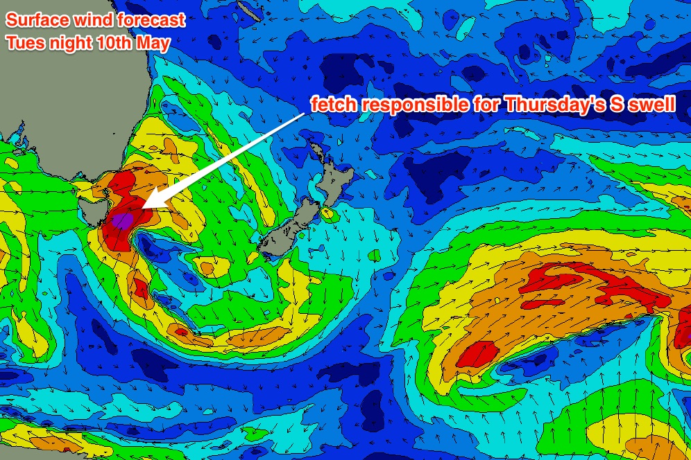
This particular fetch is only modelled to remain in the swell window for a short period of time, but I think we’ll see a strong, if only brief pulse of south swell from it on Thursday (some south facing beaches across the Lower Mid North Coast may also pick up some mid-range S’ly swell from the trailing frontal fetch late Wednesday, but at this stage it’s not worth working around).
As for size? There’ll be a large range in wave heights due to the swell direction, but I wouldn’t be surprised if some south swell magnets in Northern NSW pick up occasional 4-5ft+ sets at some point on Thursday (more likely the afternoon than the morning, especially in the north). But, the acute southerly swell direction will limit wave heights at beaches not open to the south (2-3ft most beaches, tops), and protected locations will be tiny. SE Qld will see hardly any swell from this system.
The outlook beyond this is very exciting if you like solid south swells. A strong front will push through the southern Tasman Sea overnight on Wednesday, setting up a sustained south-west tending southerly fetch at gale to storm force, off the southern NSW coast.
This is expected to generate a bigger southerly swell that will build through Friday, peaking on Saturday - wave heights should reach 6-8ft at south facing beaches in Northern NSW at the height of the swell. Those beaches not open to the swell should see 3-5ft surf, with much smaller waves inside sheltered points and southern corners.
Although the swell direction will again remain very unfavourable for SE Qld, we will see some small lines push through here, around 2ft at the outer points, maybe even 2-3ft if we're lucky. Surf size should remain strong through Sunday although ease steadily in size.
So, next weekend is certainly looking sizeable from the south (south of the border), if that’s your kinda thing.
Have a great weekend, see you on Monday!
Comments
Burleigh's looking fun as the east swell continues to incrementally build in size.
Does the sunny coast catch south swells? Sorry probably a noob question here
Northern swell magnet ,Sunny coast , was crap , SE up early, some sets to 3 ft tho. Could do with some proper offshore ...
Loaded the boards and gear into the car already. Question is, do I head North or South in the morning? Swell showing on the goldy, so maybe the northern stretch will be firing (fuck the points n crowds).
Where are the best bacon an egg rolls... I use that as the guide point.
I reckon there'll be waves everywhere. Would be a good weekend to try the beachies spread between South Straddie and Jumpinpin, or across the untracked coast of southern North Straddie or Moreton etc. Ideal size range and light winds all weekend.
Well the last few days at Straddie have been excellent. Pretty much everywhere from the Spit to Surfers has looked pretty decent most mornings as well. So I'd say head north Wingnut.
Head high insider at Moffs.....
And one set at Burleigh. Nice and shapely on the high tide!
We now seem to be on the backside of the east swell, but there's still a few decent sets at open stretches. Burleigh a little while ago.